Andrew Jackson State Park is a 360-acre (1.5km2)South Carolinastate park established in 1952 to honor the only South Carolina-born president, Andrew Jackson, who was born nearby in 1767. The park is on U.S. Highway 521 about nine miles north of Lancaster, South Carolina. The park offers hiking, boating, camping, fishing and picnicking. There are 25 camping spaces with paved road access. Each space has water hookup and electricity. They are often full on weekends, But not during the week. Nearby is a 20-acre lake with an island in the middle and hiking paths all the way around it. There is abundant Wildlife.
The park's museum features exhibits about the boyhood life of U.S. President Andrew Jackson, who grew up in this region. Rooms depict Colonial period life, including a dining room, bedroom, textile room, and early tools and farm implements.
A notable park feature is a large bronze statue called Andrew Jackson, A Boy of The Waxhaws, sculpted by Anna Hyatt Huntington, that depicts a young Jackson astride a farm horse. There is a marker recognizing Jackson's birthplace that was donated by the Daughters of the American Revolution. The park also includes a replica of a late 18th-century one-room schoolhouse and an amphitheatre.
Large bronze statue of Andrew Jackson at Andrew Jackson State Park, Lancaster, SC. sculpted by Anna Hyatt Huntington.
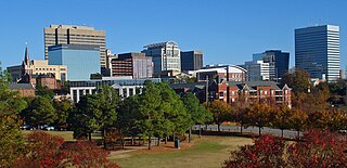
Columbia is the capital city of the U.S. state of South Carolina. With a population of 136,632 at the 2020 census, it is the second-most populous city in South Carolina. The city serves as the county seat of Richland County, and a portion of the city extends into neighboring Lexington County. It is the center of the Columbia, SC Metropolitan Statistical Area, which had an estimated population of 858,302 in 2023, and is the 70th-most populous metropolitan statistical area in the United States. The name Columbia is a poetic term used for the United States, derived from the name of Christopher Columbus, who explored for the Spanish Crown. Columbia is often abbreviated as Cola, leading to its nickname as "Soda City".
Jackson County is a county located in the Commonwealth of Kentucky. As of the 2020 census, the population was 12,955. Its county seat is McKee. The county was formed in 1858 from land given by Madison, Estill, Owsley, Clay, Laurel, and Rockcastle counties. It was named for Andrew Jackson, seventh President of the United States. Jackson County became a moist county via a "local-option" referendum in the Fall of 2019 that legalized the sale of alcoholic beverages in the city of McKee.
The Hermitage is a historical museum located in Davidson County, Tennessee, United States, 10 miles (16 km) east of downtown Nashville. The 1,000-acre (400 ha)+ site was owned by Andrew Jackson, the seventh president of the United States, from 1804 until his death at the Hermitage in 1845. It also serves as his final resting place. Jackson lived at the property intermittently until he retired from public life in 1837.
Charles Lee Tilden Regional Park, also known as Tilden Park or Tilden, [], is a 2,079-acre (841 ha) regional park in the East Bay, part of the San Francisco Bay Area in California. It is between the Berkeley Hills and San Pablo Ridge. Its main entrance is near Kensington, Berkeley, and Richmond. The park is contiguous with Wildcat Canyon Regional Park.
Morrow Mountain State Park is a state park in Stanly County, North Carolina, U.S. Located near Albemarle, the park includes 5,881 acres (23.80 km2) within the Uwharrie Mountains.
Pettigrew State Park is a North Carolina State Park in Tyrrell and Washington Counties, North Carolina in the United States. It covers 5,951 acres (24.08 km2) around the shore lines of Lake Phelps and the Scuppernong River. The park's developed facilities are south of U.S. Route 64 near Roper and Creswell, North Carolina. Pettigrew State Park is open for year-round recreation, including hiking, camping, fishing, boating and picnicking.
Pilot Mountain State Park is a North Carolina state park in Surry and Yadkin Counties, North Carolina in the United States. Located near Pinnacle, North Carolina on highway US 52, it covers 3,872 acres (15.67 km2) and includes the distinctive 2,241 foot (683 m) peak of Pilot Mountain.
Singletary Lake State Park is a North Carolina state park in Bladen County, North Carolina in the United States. Located near Elizabethtown, it covers 1,221 acres (4.94 km2), including Singletary Lake, one of the largest Carolina bays. Singletary Lake State Park is southeast of Elizabethtown on North Carolina Highway 53 in North Carolina's Coastal Plain region. It serves primarily as a group camp but is open on a limited basis for year-round recreation, including hiking, fishing and observing nature.
William B. Umstead State Park is a North Carolina state park in Wake County, North Carolina in the United States. It covers 5,599 acres (22.66 km2) nestled between the expanding cities of Raleigh, Cary, and Durham, North Carolina. It offers hiking, bridle, and bike trails, boat rentals, camping, picnic areas, and educational programs.
Eisenhower National Historic Site preserves the home and farm of Dwight D. Eisenhower, the 34th president of the United States, and its surrounding property of 690.5 acres (279.4 ha). It is located in Cumberland Township, Adams County, Pennsylvania, just outside Gettysburg. Purchased by then-General Eisenhower and his wife Mamie in 1950, the farm served as a weekend retreat for the President and a meeting place for world leaders, and became the Eisenhowers' home after they left the White House in 1961.
Abraham Lincoln Birthplace National Historical Park is a designated U.S. historic park preserving two separate farm sites in LaRue County, Kentucky, where Abraham Lincoln was born and lived early in his childhood. He was born at the Sinking Spring site south of Hodgenville and remained there until the family moved to the Knob Creek Farm northeast of Hodgenville when he was two years old, living there until he was seven years of age. The park's visitor center is located at the Sinking Spring site.
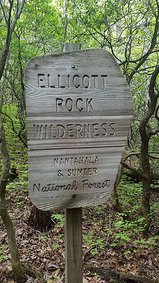
Ellicott Rock Wilderness is a wild area lying at and around the tripoint of Georgia, North Carolina, and South Carolina, spanning 8,274 acres. It is managed by the United States Forest Service and is part of the National Wilderness Preservation System.
The Sumter National Forest is one of two forests in South Carolina that are managed together by the United States Forest Service, the other being the Francis Marion National Forest. The Sumter National Forest consists of 370,442 acres (1,499.13 km2) which are divided into 3 distinct sections in western and central South Carolina. The Enoree Ranger District is the largest, comprising roughly 170,000 acres in Chester, Fairfield, Laurens, Newberry, and Union counties. Next is the Long Cane Ranger District, comprising about 120,000 acres in Abbeville, Edgefield, Greenwood, McCormick, and Saluda counties. The smallest district is the Andrew Pickens Ranger District comprising over 85,000 acres which lies entirely in Oconee county and is part of the Appalachian Mountains. Forest headquarters of both South Carolina forests are located together in the state's capital city of Columbia.
Rancho San Antonio County Park and Rancho San Antonio Open Space Preserve are a conjoined public recreational area in the Santa Cruz Mountains, in the northwest quadrant of Santa Clara County, California. The County Park is bordered by Los Altos with some parts of the eastern part of the County Park in western Cupertino. The Open Space Preserve is on the west side of the County Park, also bordered by Los Altos Hills, Monte Bello Open Space Preserve, and the Permanente Quarry.
Table Rock State Park is a 3,083-acre (12.48 km2) park at the edge of the Blue Ridge Mountains in northern Pickens County, South Carolina. The park includes Pinnacle Mountain, the tallest mountain totally within the state.
David Crockett Birthplace State Park is a state park in Greene County, Tennessee, United States. Situated along the Nolichucky River, the park consists of 105 acres (0.42 km2) centered on the traditional birthplace of legendary Tennessee frontiersman, soldier, and politician Davy Crockett (1786-1836). The park includes a replica of Crockett's birth cabin, a museum, and a large campground.
Paris Mountain State Park is a state park in the U.S. state of South Carolina, located five miles (8 km) north of Greenville. Activities available in the 1,540-acre (6 km2) park include hiking, biking, swimming and picnicking. The 13-acre (52,609 m2) Lake Placid offers swimming and fishing. Canoes, kayaks, and pedal boats are seasonally available for rental; private boats are not permitted. Camping is allowed and campsites range from rustic, back country sites to paved sites with water and electricity hook-ups. The park's Civilian Conservation Corps (CCC) structures, including the Camp Buckhorn lodge, are listed on the National Register of Historic Places. m.
Montgomery Bell State Park is a Tennessee state park in Burns, Tennessee, United States. The park covers 3,782 acres (1,531 ha) and its official elevation is 758 feet (231 m). However, due to the dissected wooded terrain typical of the Nashville Basin, actual elevations range from 580 feet to 860 feet. The park is open for year-round recreation including boating, hiking, camping, fishing and golf. Montgomery Bell State Park was built during the Great Depression by members of the Works Progress Administration and Civilian Conservation Corps as Montgomery Bell Recreational Demonstration Area. Named for iron industrialist Montgomery Bell, the park is known as the birthplace of the Cumberland Presbyterian Church.
Croft State Park is a state park in Spartanburg County, South Carolina, located on land used during World War II as Camp Croft, a US Army basic training center and prisoner-of-war camp.
This page is based on this Wikipedia article Text is available under the CC BY-SA 4.0 license; additional terms may apply. Images, videos and audio are available under their respective licenses.