Lake Michigan is one of the five Great Lakes of North America. It is the second-largest of the Great Lakes by volume and the third-largest by surface area, after Lake Superior and Lake Huron. To the east, its basin is conjoined with that of Lake Huron through the narrow Straits of Mackinac, giving it the same surface elevation as its easterly counterpart; the two are technically a single lake.
Elgin is an incorporated town in Kershaw County, South Carolina, United States. It is located approximately 20 miles (32 km) northeast of the center of Columbia, the state's capital, and is the center of one of the ten townships that make up Kershaw County. As of the 2010 census, the town's population was 1,311, and in 2018 the estimated population was 1,579. It is part of the Columbia, South Carolina Metropolitan Statistical Area.
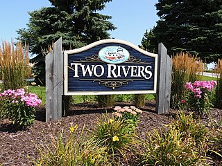
Two Rivers is a city in Manitowoc County, Wisconsin, United States. The population was 11,712 at the 2010 census. It is the birthplace of the ice cream sundae. The city's advertising slogan is "Catch our friendly waves" as it is located along Lake Michigan.
Carolina bays are elliptical to circular depressions concentrated along the Atlantic seaboard within coastal New York, New Jersey, Delaware, Maryland, Virginia, North Carolina, South Carolina, Georgia, and north Florida. In Maryland, they are called Maryland basins. Within the Delmarva Peninsula, they and other coastal ponds are also called Delmarva bays.

Jones Lake State Park is a North Carolina state park in Bladen County, North Carolina in the United States near Elizabethtown. It covers 2,208-acre (8.94 km2), including the Carolina bay lakes of Jones Lake and Salters Lake. Jones Lake State Park is north of Elizabethtown on North Carolina Highway 242 in North Carolina's Coastal Plain region. The park offers year-round recreation, including fishing, swimming, boating, hiking, picnicking and environmental and historical education programs.

Lake Waccamaw State Park is a North Carolina state park in Columbus County, North Carolina, in the United States. Located near the town of Lake Waccamaw, North Carolina, it covers 2,398-acre (9.70 km2), along the shores of Lake Waccamaw, a Carolina bay. Recent work by the U.S. Geological Survey has interpreted the Carolina Bays as relict thermokarst lakes that formed several thousands of years ago when the climate was colder, drier, and windier. Thermokarst lakes develop by thawing of frozen ground (permafrost) and by subsequent modification by wind and water. Thus, this interpretation suggests that permafrost once extended as far south as the Carolina Bays during the last ice age and (or) previous ice ages.

Pettigrew State Park is a North Carolina State Park in Tyrrell and Washington Counties, North Carolina in the United States. It covers 5,951 acres (24.08 km2) around the shore lines of Lake Phelps and the Scuppernong River. The park's developed facilities are south of U.S. Route 64 near Roper and Creswell, North Carolina. Pettigrew State Park is open for year-round recreation, including hiking, camping, fishing, boating and picnicking.

Singletary Lake State Park is a North Carolina state park in Bladen County, North Carolina in the United States. Located near Elizabethtown, it covers 1,221-acre (4.94 km2), including Singletary Lake, one of the largest Carolina bays. Singletary Lake State Park is southeast of Elizabethtown on North Carolina Highway 53 in North Carolina's Coastal Plain region. It serves primarily as a group camp but is open on a limited basis for year-round recreation, including hiking, fishing and observing nature.

The Kobuk River is a river located in the Arctic region of northwestern Alaska in the United States. It is approximately 280 miles (451 km) long. Draining a basin with an area of 12,300 square miles (32,000 km2), the Kobuk River is among the largest rivers in northwest Alaska with widths of up to 1500 feet and flow at a speed of 3–5 miles per hour in its lower and middle reaches. The average elevation for the Kobuk River Basin is 1,300 feet (400 m) above sea level, ranging from near sea level to 11,400 feet. Topography includes low, rolling mountains, plains and lowlands, moderately high rugged mountainous land, and some gently sloped plateaus and highlands. The river contains an exceptional population of sheefish, a large predatory whitefish within the salmon family, found throughout the Arctic that spawns in the river's upper reaches during the autumn. A portion of the vast Western Arctic Caribou Herd utilize the Kobuk river valley as winter range.

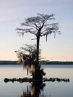
Lake Waccamaw is a fresh water lake located in Columbus County in North Carolina. It is the largest of the natural Carolina Bay lakes. Although bay trees are present within many Carolina Bays, the term "bay" does not refer to the trees but comes instead from an early science publication by Glenn (1895), who used the word "bay" to refer to these features near the town of Darlington, South Carolina. Lake Waccamaw is fed by four creeks: First, Second, Third, and Big creeks. The outlet forms the Waccamaw River which flows southeasterly to empty into the Atlantic Ocean near Georgetown, South Carolina

The Sandhills or Carolina Sandhills is a 10-35 mi wide physiographic region within the U.S. Atlantic Coastal Plain province, along the updip (inland) margin of this province in the States of North Carolina, South Carolina, and Georgia. The extent of the Carolina Sandhills is shown clearly in maps of the ecoregions of North Carolina, South Carolina, and Georgia.

Awenda Provincial Park is a provincial park in Tiny Township, Simcoe County in Central Ontario, Canada, located on a peninsula jutting into Georgian Bay north of Penetanguishene. The park occupies an area of 2,915 hectares and was established in 1975. It is classified as a Natural Environment Park and therefore all land is protected.

Thermokarst is a terrain-type, characterised by very irregular surfaces of marshy hollows and small hummocks formed as ice-rich permafrost thaws. The land surface type occurs in Arctic areas, and on a smaller scale in mountainous areas such as the Himalayas and the Swiss Alps.
Lake Phelps is North Carolina's second largest natural lake. It has a surface area of 16,600 acres (67 km2), and it is located primarily in Washington County on the Albemarle-Pamlico Peninsula between the Albemarle Sound and the Pamlico Sound. The easternmost part of the lake extends into Tyrrell County.
Yedoma is an organic-rich Pleistocene-age permafrost with ice content of 50–90% by volume. Yedoma are abundant in the cold regions of eastern Siberia, such as northern Yakutia, as well as in Alaska and the Yukon.
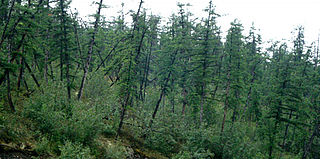
Drunken trees, tilted trees, or a drunken forest, is a stand of trees rotated from their normal vertical alignment.
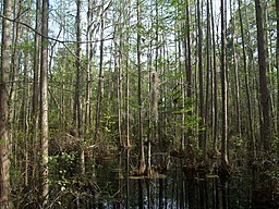
Singletary Lake, surrounded by Singletary Lake State Park in Bladen County, North Carolina in the United States, is one of a series of Carolina bay lakes that stretch from New Jersey to Florida along the Atlantic Coastal Plain. Recent work by the U.S. Geological Survey has interpreted the Carolina Bays as relict thermokarst lakes that formed several thousands of years ago when the climate was colder, drier, and windier. Thermokarst lakes develop by thawing of frozen ground (permafrost) and by subsequent modification by wind and water. Thus, this interpretation suggests that permafrost once extended as far south as the Carolina Bays during the last ice age and (or) previous ice ages. Singletary Lake is not fed by any stream, but relies entirely upon rain. The land beneath and surrounding the lake is mica-rich sandy clay and sand that is from the Upper Cretaceous era with a thin layer of Pleistocene deposits covering it. This land is lower than the surrounding land and drains very poorly, creating Singletary Lake.

Sergey Aphanasievich Zimov is a Russian geophysicist who specialises in arctic and subarctic ecology. He is the Director of Northeast Scientific Station, a senior research fellow of the Pacific Institute for Geography, and one of the founders of Pleistocene Park. He is best known for his work in advocating the theory that human overhunting of large herbivores during the Pleistocene caused Siberia's grassland-steppe ecosystem to disappear and for raising awareness as to the important roles permafrost and thermokarst lakes play in the global carbon cycle.

Little Pee Dee State Park is a state park located near the town of Dillon in Dillon County, South Carolina. The park land includes a part of a Carolina Bay and adjacent sand rim. Recent work by the U.S. Geological Survey has interpreted the Carolina Bays as relict thermokarst lakes that formed several thousands of years ago when the climate was colder, drier, and windier. Thermokarst lakes develop by thawing of frozen ground (permafrost) and by subsequent modification by wind and water. Thus, this interpretation suggests that permafrost once extended as far south as the Carolina Bays during the last ice age and (or) previous ice ages.
Lewis Ocean Bay Heritage Preserve is a 10,427-acre natural preserve near Carolina Forest, South Carolina.