Related Research Articles

The Arctic Archipelago, also known as the Canadian Arctic Archipelago, is an archipelago lying to the north of the Canadian continental mainland, excluding Greenland and Iceland.
The Reed Gold Mine is located in Midland, Cabarrus County, North Carolina, and is the site of the first documented commercial gold find in the United States. It has been designated a National Historic Landmark because of its importance and listed on the National Register of Historic Places
The Little Pee Dee River is a 116-mile-long (187 km) tributary of the Pee Dee River. The Little Pee Dee technically arises near Laurinburg, North Carolina as Gum Swamp, which flows southward, receiving several small tributaries, across the South Carolina border into Red Bluff Lake, near McColl, South Carolina. The lake is at an elevation of 135 feet (41 m) above sea level, and from the outlet of the lake, the flow is called the Little Pee Dee River. The Little Pee Dee River is named after the Pee Dee Indian Tribe. Today, the tribe still occupies some of the land, although the tribe only consists of just over 200 enrolled members.

Pokagon State Park is an Indiana state park in the northeastern part of the state, near the village of Fremont and 5 miles (8 km) north of Angola. It was named for the 19th-century Potawatomi chief, Leopold Pokagon, and his widely known son, Simon Pokagon, at Richard Lieber's suggestion. The 1,260-acre (5.1 km2) park has an inn, camping facilities, and a staff of full-time naturalists. Pokagon receives nearly 640,000 visitors annually.
Stone State Park is a state park in Iowa, United States, located in the bluffs and ravines adjacent to the Big Sioux River. The park is located on the northwestern edge of Sioux City and consists of 1,069 acres (433 ha) in Woodbury and Plymouth Counties, and overlooks the South Dakota-Iowa border. Stone Park is near the northernmost extent of the Loess Hills, and is at the transition from clay bluffs and prairie to sedimentary rock hills and bur oak forest along the Iowa side of the Big Sioux River. A variety of prairie plants can be found on the steep slopes and ridges, including yucca, penstemon, rough blazing star, silky aster, and pasque flower. Wild turkey, white-tailed deer, coyote, and red fox are found in the park. Birdlife includes the turkey vulture, barred owl, rufous-sided (eastern) towhee, and the ovenbird. Exposed bedrock in the park is composed of lignite, shale, sandstone, and limestone, and dates to the Cretaceous period; it is rich in marine fossils. The park contains many miles of hiking and equestrian trails, and is a popular destination for day visitors, overnight campers, mountain bike enthusiasts, and picnickers.

The Linville Gorge Wilderness is the third largest wilderness area in North Carolina and one of only two wilderness gorges in the Southern United States. Maintained by the United States Forest Service, it comprises 11,786 acres (47.70 km2) around the Linville River, and is situated inside the Pisgah National Forest. The river is approximately 1,400 feet (430 m) below the ridge, thus hiking in and out of the Gorge is challenging and enjoyable for those who like serious hiking. The plant and animal community is extremely diverse, with a dense hardwood/pine forest and a wide variety of smaller trees and other plants as well as bear, fox, raccoon, trout, grouse, wild turkey, vultures, owls, hawks, copperheads, and timber rattlesnakes.
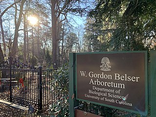
W. Gordon Belser Arboretum is part of the University of South Carolina in Columbia, South Carolina, managed by the Department of Biological Sciences. The arboretum serves as a nature preserve, field laboratory and research site for students and faculty. It is open to the public at a monthly open house. A small botanic garden features shrubs and small trees suitable for Columbia's home landscapes. The remaining landscape features southeast native trees and plant communities and is a certified Palmetto Wildlife Habitat.

Roan Mountain is a 6,277 ft (1,913 m) mountain straddling the North Carolina/Tennessee border in the Unaka Range of the Southern Appalachian Mountains in the Southeastern United States. The range's highpoint, Roan is clad in a dense stand of Southern Appalachian spruce-fir forest, and includes the world's largest natural rhododendron garden, and the longest stretch of grassy bald in the Appalachian range. The Roan Highlands also contain the highest quality remaining stretch of Fraser fir forest throughout the tree's entire range. The Cherokee National Forest and Pisgah National Forest converge atop the mountain, with Roan Mountain State Park located near its northern base. The Appalachian Trail traverses most of the Roan's crest. The Roan High Knob Shelter is the highest back-country shelter on the entire 2,174-mile (3,499 km) trail.
The Waccamaw River Heritage Preserve is a 5,347-acre (21.64 km2), 30-mile (48 km) stretch of protected wetland that follows the Waccamaw River in northeastern Horry County, South Carolina.
William W. Powers State Recreation Area is an Illinois state park administered by the Illinois Department of Natural Resources on 580 acres (230 ha) in the Hegewisch community area of the City of Chicago in Cook County, Illinois, United States. The area includes 419 acres (170 ha) of water in Wolf Lake that provides about 6 miles (10 km) of shoreline to fishermen. The park hosts about half a million visitors annually. The park contains numerous species, and is one of the most important biological sites in the Chicago region.

Rocks State Park is a public recreation area located in and around Deer Creek Valley near Pylesville, Harford County, Maryland. The state park's 1,060 acres (430 ha) preserve the geologic formation known as the King and Queen's Seat and other features in three non-contiguous areas near the junction of Maryland Route 24 and Maryland Route 165. It is managed by the Maryland Department of Natural Resources.

Stewarts Point State Marine Reserve (SMR) and Stewarts Point State Marine Conservation Area (SMCA) are two adjoining marine protected areas that extend offshore from about a mile south of Black Point to Fisk Mill Cove, in Sonoma County on California’s north central coast. The marine protected areas cover 25.22 square miles (65.3 km2). Stewarts Point SMR prohibits the take of all living marine resources. Stewarts Point SMCA prohibits the take of all living marine resources, except recreational shore based take of marine aquatic plants, marine invertebrates, finfish by hook and line, surf smelt by beach net, and species authorized by Title 14 Section 28.80 by hand-held dip net.

The Yadkin–Pee Dee River Basin is a large river basin in the eastern United States, covering around 7,221 square miles, making it the second largest in the state of North Carolina. Its headwaters rise near Blowing Rock, North Carolina, and the basin drains to the Atlantic Ocean in Winyah Bay, east of Georgetown, South Carolina.

The South Toe River is a river in Yancey County in Western North Carolina. The name Toe is taken from its original name Estatoe, pronounced 'S - ta - toe', a native American name associated with the Estatoe trade route leading down from the NC mountains through Brevard where there is a historical plaque with information that affirms the route, on into South Carolina where a village of the same name was located.

Judaculla Rock is a curvilinear-shaped outcrop of soapstone known for its ancient carvings and petroglyphs. The archaeological site is located on a 0.85-acre rectangular-shaped property, now owned by Jackson County. It is approximately 60 meters east of Caney Fork Creek, a major branch of the northwestward-trending Tuckasegee River in the mountains of Western North Carolina.
The St. Helena Sound Heritage Preserve is a collection of Sea Islands totaling 10,301 acres (41.69 km2) of upland and wetland property located along the Saint Helena Sound in the Lowcountry region of South Carolina. Owned and managed by the South Carolina Department of Natural Resources (SCDNR), the preserve is also considered to be a designated Wildlife Management Area and a portion of the ACE Basin area. Listed below are properties that consist of the preserve:
Hamma Hamma Balds is a Washington state Natural Area Preserve. It is located in the eastern foothills of the Olympic Mountains in Mason County, above the Hamma Hamma River and adjacent to Olympic National Forest. The term "balds" refers to rocky outcroppings in the heavy forest. The preserve totals 957 acres (387 ha).
Lewis Ocean Bay Heritage Preserve is a 10,427-acre natural preserve near Carolina Forest, South Carolina.
References
- 1 2 "South Carolina Department of Natural Resources". www2.dnr.sc.gov.
- ↑ "Discover Bald Rock". discoversouthcarolina.com.