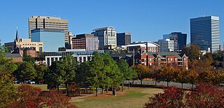
Columbia is the capital of the U.S. state of South Carolina. With a population of 136,632 as of the 2020 U.S. Census, it is the second-largest city in South Carolina. The city serves as the county seat of Richland County, and a portion of the city extends into neighboring Lexington County. It is the center of the Columbia metropolitan statistical area, which had a population of 829,470 and is the 72nd-largest metropolitan statistical area in the nation. The name Columbia is a poetic term used for the United States, derived from the name of Christopher Columbus, who explored for the Spanish Crown. Columbia is often abbreviated as Cola, leading to its nickname as "Soda City."

Richland County is located in the U.S. state of South Carolina. As of the 2020 census, the population was 416,147, making it the second-most populous county in South Carolina, behind only Greenville County. The county seat and largest city is Columbia, the state capital. The county was established on March 12, 1785. Richland County is part of the Columbia, SC Metropolitan Statistical Area. In 2010, the center of population of South Carolina was located in Richland County, in the city of Columbia.
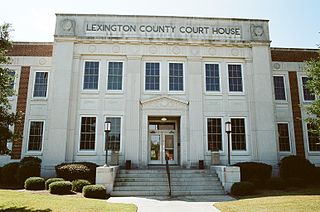
Lexington County is a county located in the U.S. state of South Carolina. As of the 2020 census, the population was 293,991, and the 2021 population estimate was 300,137. Its county seat and largest town is Lexington. The county was chartered in 1785 and was named in commemoration of Lexington, Massachusetts, the site of the Battle of Lexington in the American Revolutionary War. Lexington County is the sixth-largest county in South Carolina by population and is part of the Columbia, SC Metropolitan Statistical Area.

Fairfield County is a county located in the U.S. state of South Carolina. As of the 2020 census, its population was 20,948. Its county seat is Winnsboro.
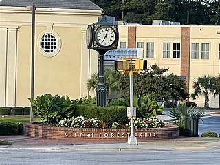
Forest Acres is a city in Richland County, South Carolina, United States. The population was 10,606 at the 2020 census. It is part of the Columbia, South Carolina, Metropolitan Statistical Area and is an enclave of the city of Columbia.

Blythewood is a town in Richland and Fairfield counties, South Carolina, United States. It is a suburb of Columbia, South Carolina. The 2020 United States census puts the population at 4,772, up from 2,034 in 2010. Since 2000, the population has increased by 3,119 percent. It is part of the Columbia, South Carolina, Metropolitan Statistical Area. It is located around 15 miles from downtown Columbia.

The Midlands region of South Carolina is the middle area of the state. The region's main center is Columbia, the state's capital. The Midlands is so named because it is halfway point between the Upstate and the Lowcountry. The main area code is 803.
Richland County School District One, is a school district with its headquarters in the Stevenson Administration Building in Columbia, South Carolina.
Richland County School District Two is a nationally recognized school district located in suburban Columbia, South Carolina, United States, in the northeast section of Richland County. It is one of the fastest growing districts in South Carolina, with a current student population above 28,000. It operates 40 schools and centers, two district child development programs, two alternative schools, an adult/community center and several magnet centers and programs at all grade levels. The district offices are in an unincorporated area.
School District Five of Lexington and Richland Counties is a South Carolina school district encompassing a land area of approximately 196 square miles, (508 km2) roughly half of which is situated in each of Lexington and Richland Counties. Student enrollment is at 16,717 as of August 2005. The school district consists of the northern portion of Lexington County lying north of Lake Murray and the Saluda River and the northwestern portion of Richland County lying south of the Broad River. The School District is primarily a residential suburb located to the northwest of the city of Columbia, the capital city of South Carolina. Included in the District Five are the towns of Irmo and Chapin. The school district has three attendance areas: Chapin, Dutch Fork, and Irmo. District Five operates a total of 12 elementary schools, four middle schools, five high schools, and one alternative school. The interim Superintendent is Akil Ross, appointed in June 2021 following the sudden resignation of former superintendent Christina Melton at a board meeting on June 14 over conflicts with some school board members. The Chief Instructional Officer is Michael Guliano.

Hopkins is a census-designated place (CDP) in Richland County, South Carolina, United States, that was founded circa 1836 and named after John Hopkins. It is located 11 miles (18 km) southeast of downtown Columbia and is part of the Columbia Metropolitan Statistical Area. As of the 2010 census, the population of the Hopkins CDP was 2,882.

Columbiana Centre is a one-story indoor shopping mall located off Interstate 26/U.S. Route 76 on Harbison Boulevard in Columbia, South Carolina that opened in 1990. Most of the mall's territory is located in Lexington County, although portions of the mall extend into Richland County. The regional mall has 788,103 square feet (73,217.2 m2) of retail space. Its anchors include two Belk stores, Dillard's, and JCPenney. The Men's Belk opened in early 2015 in the former Sears which closed in 2014.

Midlands Technical College is a public technical college with multiple locations in the Richland, Lexington, and Fairfield counties of South Carolina. The college is one of South Carolina's largest two-year college with approximately 16,000 students. It offers approximately one hundred associate degrees, diplomas and certificate programs of study and is the largest source of transfer students to the University of South Carolina-Columbia.

As defined by the U.S. Office of Management and Budget, and used by the U.S. Census Bureau for statistical purposes only, the Columbia metropolitan statistical area, is an area consisting of six counties in central South Carolina, anchored by the city of Columbia. The current population has an estimation of 837,092. It is the second-largest metropolitan statistical area in the state of South Carolina, since the Anderson metropolitan statistical area was combined with Greenville's following the 2010 census.
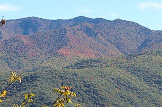
Richland Balsam is a mountain in the Great Balsam Mountains in the U.S. state of North Carolina. Rising to an elevation of 6,410 feet (1,950 m), it is the highest mountain in the Great Balsam range, is among the 20 highest summits in the Appalachian range, and is the ninth highest peak in the East of the United States. The Blue Ridge Parkway reaches an elevation of 6,053 feet (1,845 m)— the parkway's highest point— as it passes over Richland Balsam's southwestern slope. The Jackson County-Haywood County line crosses the mountain's summit.

Gadsden is a census-designated place in Richland County, South Carolina, United States. The population was 1,632 at the 2010 census. It is part of the Columbia, South Carolina metropolitan area.
The COMET, officially the Central Midlands Regional Transit Authority (CMRTA), is a regional transportation authority formed by Richland County, City of Columbia, and Lexington County on April 24, 2000, by the Central Midlands Council of Governments. The COMET consists of an intergovernmental agreement signed by Richland County, the City of Columbia, the City of Forest Acres, and Lexington County to fund, operate and maintain public transit services and mass transportation in Richland and Lexington counties in the Columbia metropolitan area of South Carolina.

Richland Library is the public library system of Richland County, South Carolina. In December 2012, the library shortened its name from Richland County Public Library. It has 11 branches including its 242,000 sq ft (22,500 m2) Main Library. In 2001, it was named the National Library of the Year by the Library Journal and the Gale Group.

The Lake Murray Symphony Orchestra (LMSO) is an American symphony orchestra based in Columbia, South Carolina.
North Carolina Highway 121 (NC 121) is a 13.2-mile-long (21.2 km) primary state highway in the U.S. state of North Carolina. The highway travels through a short portion of northern Greene County and western Pitt County between Interstate 587 (I-587) at exit 60 and NC 43 in the unincorporated community of Bruce. Though it is signed as a north–south highway, the overall length of the route travels more east–west.

