Atlantic seaboard watershed

Last updated
Atlantic Seaboard
NorthAmerica-WaterDivides.png
The Atlantic Seaboard Watershed extends southward along the Atlantic Ocean from Nova Scotia to Florida
Location Canada and the United States
Area
  Total720,000 km2 (277,000 sq mi)

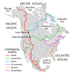
The Atlantic seaboard watershed is a watershed of the Atlantic Ocean in eastern North America along the Atlantic Canada (Maritimes) coast south of the Gulf of Saint Lawrence Watershed, and the East Coast of the United States north of the Kissimmee River watershed of Lake Okeechobee basin in the central Florida Peninsula.

The continental area east of the Appalachian Mountains and highlands to the north and south is demarcated on the south by drainage to the Lake Okeechobee basin (which drains both westward to the Gulf and eastward to ocean), the Eastern Continental Divide (ECD) to the west, and the Saint Lawrence divide to the north. US physiographic regions of this watershed are the Atlantic Plain and the Appalachian Mountains & Highlands.

Sub-watersheds adjacent to the Saint Lawrence divide
Other notable sub-watersheds
Rehoboth Bay
Indian River Bay
Assawoman Bay
Isle of Wight Bay
Sinepuxent Bay
Chincoteague Bay
Sub-watersheds adjacent to the Eastern Continental Divide

Related Research Articles

Geography of Canada Geographic features of Canada

Canada has a vast geography that occupies much of the continent of North America, sharing a land border with the contiguous United States to the south and the U.S. state of Alaska to the northwest. Canada stretches from the Atlantic Ocean in the east to the Pacific Ocean in the west; to the north lies the Arctic Ocean. Greenland is to the northeast with a shared border on Hans Island. To the southeast Canada shares a maritime boundary with France's overseas collectivity of Saint Pierre and Miquelon, the last vestige of New France. By total area, Canada is the second-largest country in the world, after Russia. By land area alone, however, Canada ranks fourth, the difference being due to it having the world's largest proportion of fresh water lakes. Of Canada's thirteen provinces and territories, only two are landlocked while the other eleven all directly border one of three oceans.

Gulf of St. Lawrence Outlet of the North American Great Lakes via the St. Lawrence River into the Atlantic Ocean

The Gulf of St. Lawrence is the outlet of the North American Great Lakes via the St. Lawrence River into the Atlantic Ocean. The gulf is a semi-enclosed sea, covering an area of about 226,000 square kilometres (87,000 sq mi) and containing about 34,500 cubic kilometres (8,300 cu mi) of water, at an average depth of 152 metres (500 ft).

Continental Divide of the Americas Principal hydrological divide of North and South America

The Continental Divide of the Americas is the principal, and largely mountainous, hydrological divide of the Americas. The Continental Divide extends from the Bering Strait to the Strait of Magellan, and separates the watersheds that drain into the Pacific Ocean from those river systems that drain into the Atlantic and Arctic oceans.

Drainage basin Area of land where precipitation collects and drains off into a common outlet

A drainage basin is any area of land where precipitation collects and drains off into a common outlet, such as into a river, bay, or other body of water. The drainage basin includes all the surface water from rain runoff, snowmelt, hail, sleet and nearby streams that run downslope towards the shared outlet, as well as the groundwater underneath the earth's surface. Drainage basins connect into other drainage basins at lower elevations in a hierarchical pattern, with smaller sub-drainage basins, which in turn drain into another common outlet.

Aroostook River River in New Brunswick, Canada and Maine, USA

The Aroostook River is a 112-mile-long (180 km) tributary of the Saint John River in the U.S. state of Maine and the Canadian province of New Brunswick. Its basin is the largest sub-drainage of the Saint John River.

Eastern Continental Divide Hydrological divide in eastern North America

The Eastern Continental Divide, Eastern Divide or Appalachian Divide is a hydrographic divide in eastern North America that separates the easterly Atlantic Seaboard watershed from the westerly Gulf of Mexico watershed. The divide nearly spans the United States from south of Lake Ontario through the Florida peninsula, and consists of raised terrain including the Appalachian Mountains to the north, the southern Piedmont Plateau and lowland ridges in the Atlantic Coastal Plain to the south. Water including rainfall and snowfall, lakes, streams and rivers on the eastern/southern side of the divide drains to the Atlantic Ocean; water on the western/northern side of the divide drains to the Gulf of Mexico. The ECD is one of six continental hydrographic divides of North America which define several drainage basins, each of which drains to a particular body of water.

Allegheny Front Major escarpment in the Allegheny Mountains

The Allegheny Front is the major southeast- or east-facing escarpment in the Allegheny Mountains in southern Pennsylvania, western Maryland, eastern West Virginia, and western Virginia, USA. The Allegheny Front forms the boundary between the Ridge-and-Valley Appalachians to its east and the Appalachian Plateau to its west. The Front is closely associated with the Appalachian Mountains' Eastern Continental Divide, which in this area divides the waters of the Ohio/Mississippi river system, flowing to the Gulf of Mexico, from rivers flowing into Chesapeake Bay and from there into the Atlantic Ocean.

Kissimmee River River in Florida, United States

The Kissimmee River is a river in south-central Florida, United States that forms the north part of the Everglades wetlands area. The river begins at East Lake Tohopekaliga south of Orlando, flowing south through Lake Kissimmee into the large, shallow Lake Okeechobee. Hurricane-related floods in 1947 prompted channelization of the meandering lower stretch, completed by 1970. The straightened course reduced wetland habitat and worsened pollution. In response, ongoing efforts since the 1990s have partially restored the river's original state and revitalized the ecosystem.

Drainage divide Elevated terrain that separates neighbouring drainage basins

In topography, a drainage divide, water divide, divide, ridgeline, watershed, water parting or height of land is elevated terrain that separates neighboring drainage basins. On rugged land, the divide lies along topographical ridges, and may be in the form of a single range of hills or mountains, known as a dividing range. On flat terrain, especially where the ground is marshy, the divide may be harder to discern.

Geography of New Jersey Overview of the geography of New Jersey

New Jersey is a state within the United States of America that lies on the north eastern edge of the North American continent. It shares a land border with the state of New York along the north, ratified by both states after the New York – New Jersey Line War, which is its only straight line border. New Jersey is slightly larger than the country of Kuwait.

St. Lucie River River in the United States of America

The St. Lucie River is a 35-mile-long (56 km) estuary linked to a coastal river system in St. Lucie and Martin counties in the Florida, United States. The St. Lucie River and St. Lucie Estuary are an "ecological jewel" of the Treasure Coast, central to the health and well-being of the surrounding communities. The river is part of the larger Indian River Lagoon system, the most diverse estuarine environment in North America with more than 4,000 plant and animal species, including manatees, oysters, dolphins, sea turtles and seahorses.

Nova Scotia peninsula Peninsula in Nova Scotia

The Nova Scotia peninsula is a peninsula on the Atlantic coast of North America.

Traverse Gap

The Traverse Gap is an ancient river channel occupied by Lake Traverse, Big Stone Lake and the valley connecting them at Browns Valley, Minnesota. It is located on the border of the U.S. states of Minnesota and South Dakota. Traverse Gap has an unusual distinction for a valley: it is crossed by a continental divide, and in some floods water has flowed across that divide from one drainage basin to the other. Before the Anglo-American Convention of 1818 it marked the border between British territory in the north and U.S. – or earlier, French – territory in the south.

Continental divide Drainage divide on a continent

A continental divide is a drainage divide on a continent such that the drainage basin on one side of the divide feeds into one ocean or sea, and the basin on the other side either feeds into a different ocean or sea, or else is endorheic, not connected to the open sea. Every continent on earth except Antarctica has at least one continental drainage divide; islands, even small ones like Killiniq Island on the Labrador Sea in Canada, may also host part of a continental divide or have their own island-spanning divide. The endpoints of a continental divide may be coastlines of gulfs, seas or oceans, the boundary of an endorheic basin, or another continental divide. One case, the Great Basin Divide, is a closed loop around an endoreic basin. The endpoints where a continental divide meets the coast are not always definite since the exact border between adjacent bodies of water is usually not clearly defined. The International Hydrographic Organization's publication Limits of Oceans and Seas defines exact boundaries of oceans, but it is not universally recognized. Where a continental divide meets an endorheic basin, such as the Great Divide Basin of Wyoming, the continental divide splits and encircles the basin. Where two divides intersect, they form a triple divide, or a tripoint, a junction where three watersheds meet.

Bifurcation lake

A bifurcation lake is a lake that has outflows into two different drainage basins and thus the drainage divide cannot be defined exactly because it is situated in the middle of the lake.

Watersheds of North America

Watersheds of North America are large drainage basins which drain to separate oceans, seas, gulfs, or endorheic basins. There are six generally recognized hydrological continental divides which divide the continent into seven principal drainage basins spanning three oceans and one endorheic basin. The basins are the Atlantic Seaboard basin, the Gulf of Mexico basin, the Great Lakes-St. Lawrence basin, the Pacific basin, the Arctic basin, the Hudson Bay basin, and the Great Basin. Together, the principal basins span the continent with the exception of numerous smaller endorheic basins.

Fisheating Creek Creek in Florida, United States

Fisheating Creek is a stream that flows into Lake Okeechobee in Florida. It is the only remaining free-flowing water course feeding into the lake, and the second-largest natural source for the lake. Most of the land surrounding the stream is either publicly owned or under conservation easements restricting development. The lower part of the stream remains in a largely natural state, and efforts are underway to restore the upper part of the stream to a more natural state.

Saint Lawrence River Divide Hydrological divide in eastern North America

The Saint Lawrence River Divide is a continental divide in central and eastern North America that separates the Great Lakes-St. Lawrence River Basin from the southerly Atlantic Ocean watersheds. Water, including rainfall and snowfall, lakes, rivers and streams, north and west of the divide, drains into the Gulf of St. Lawrence or the Labrador Sea; water south and east of the divide drains into the Atlantic Ocean or Gulf of Mexico. The divide is one of six continental divides in North America that demarcate several watersheds that flow to different gulfs, seas or oceans.

Wolastoq

Wolastoq is a river flowing within the Dawnland region approximately 418 miles (673 km) from headwaters in the Notre Dame Mountains near the Maine-Quebec border through New Brunswick to the northwest shore of the Bay of Fundy. The river and its tributary drainage basin form the territorial countries of the Wolastoqiyik and Passamaquoddy First Nations prior to European colonization, and it remains a cultural centre of the Wabanaki Confederacy to this day. As the longest river between Chesapeake Bay and the Gulf of Saint Lawrence the Saint John offered one of the best transportation corridors for First Nations refugees to retreat from the English colonization of North America's Atlantic coast. The Wolastoqiyik and their Acadian allies retreated upstream after English victories in the French and Indian War to establish the Republic of Madawaska on the remote upper river. Inhabitants of the upper river rejected both Canada and United States sovereignty until the present Canada–United States border was established by the Webster-Ashburton Treaty of 1842. The lower river has been developed for agriculture and industry, while the United States portion of the river upstream of Madawaska remains the sparsely populated North Maine Woods. The historic isolation of Madawaska has helped preserve the Acadian French dialect.

References

  1. "Chedabucto Bay". Archived from the original on 2011-07-06. Retrieved 2010-04-10.
  2. "Archived copy" (PDF). Archived from the original (PDF) on 2011-07-18. Retrieved 2010-08-10.{{cite web}}: CS1 maint: archived copy as title (link)
  3. [ permanent dead link ]
  4. "Bureau of Water -- Outreach". Archived from the original on 2010-06-03. Retrieved 2010-08-10.