Audomarois

Last updated

Audomarois is an "administrative division" in the Pas-de-Calais department of France, once mainly used as a market garden. As its name suggests, it is centered around the town of Saint-Omer and the Marais Audomarois.

Contents

Etymologically, "Audomarois" also refers to the inhabitants of the town of Saint-Omer and those of the Marais Audomarois. In 638, King Dagobert decided to Christianize the north of his kingdom and entrusted this mission to 4 monks: Omer, Bertin, Momelin and Ebertram. Audomar (an early form of Omer) became Bishop of Thérouanne.

Location

The Audomarois, which straddles the Nord and Pas-de-Calais départements, is part of the Saint-Omer arrondissement. It is also largely within the boundaries of the Caps et Marais d'Opale Regional Nature Park.

On the Flanders side, it borders Blootland (Dunkirk) to the north, Houtland to the east, Pale of Calais to the north-west, and the Lys plain to the south-east. On the Artois side, it borders the Licques plateau and Boulonnais to the west, and the Fruges plateau to the south-west.

Physical data

Geology and geomorphology

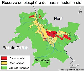
The Audomarois is located in the lower region of the Flemish maritime pre-plain. [1] Pale of Calais and Blootland to the north, the Lys plain to the south, Inner Flanders or Houtland to the east, and the Licques plateau to the west delimit the Audomarois natural region.

Location of the Audomarois among the natural regions of Nord-Pas-de-Calais. Regions naturelles du Nord Pas de Calais.jpg
Location of the Audomarois among the natural regions of Nord-Pas-de-Calais.

The Aa valley marks the landscape, as does the Neufossé Canal, which has linked the Lys to the Aa since 1753 and serves as a dividing line with Flanders. The Audomarois marsh was originally a depression in Clairmarais, near Saint-Omer, and is thought to have been a buttonhole excavated in the Ypresian clay by block tectonics.

The Marais Audomarois is surrounded to the west by the hills of the Haut-Pays de l'Artois, and to the east by the chain of Flanders mountains and inland "wooded" Flanders (Houtland). The hillsides are occupied by limestone grasslands near Helfaut.

The national nature reserve of the Romelaere ponds. Clairmarais-reserve.jpg
The national nature reserve of the Romelaëre ponds.

Hydrographic network and water resources

Covering an area of 660 km2, the Audomarois includes 90 km of "main rivers". [2] Their final outlet is the North Sea, via the wateringues network and the remarkable semi-natural environment of the Etangs du Romelaëre, home to the Etangs du Romelaëre National Nature Reserve. The Audomarois region is mainly irrigated and drained by the Aa, a coastal river that flows into the North Sea at Gravelines.

In the Middle Ages, the port of Gravelines was the outport of Saint-Omer (itself a port town during the Carolingian sea-raising period).

One of the arms of the Aa at Arques (Basse-Meldyck). AaBasseMel.JPG
One of the arms of the Aa at Arques (Basse-Meldyck).

The Audomarois is home to water resources that are used far beyond the Audomarois itself. It benefits from surface water (continental water mass) and two aquifers, one of which is exploitable and exploited: the Chalk groundwater mass (code 1001), the other being the Tertiary sand groundwater mass (code 1014).

Water quality and quantity assessment (2008 status) :

Human data and traditional economy

History

The Audomarois region is closely linked to the history of the town of Saint-Omer and the nearby marshes (around 3,700 hectares of wetlands in 2010, the relics of an immense marsh drained by 160 km of "watergangs" since the early Middle Ages). [3] In the early Middle Ages, this region developed as a counterpart to Thérouanne, around a number of major abbeys and trading centers.

The town was established and fortified in the 11th century. It lost some of its commercial importance in the 17th century, but remained an important military and religious center.

Like much of the region, the Audomarois has experienced the vicissitudes of numerous conflicts, from the Gallo-Roman period to the Second World War. Numerous traces remain, including two imposing blockhouses (Coupole d'Helfaut and Blockhaus d'Éperlecques, now places of remembrance and culture).

In the 19th century, industry (spinning mills, paper mills , etc.) boosted the demographics of the Audomar region, then in the 20th century, despite significant emigration to the nearby coalfields. [4] Rural society then became more working-class. [4] In the post-war period, factories were rapidly rebuilt in the Aa valley, and on the banks of the Canal de Noeufossé, an industry took off that would last until the end of the 20th century: the Verrerie-cristallerie d'Arques, which became Arc International, directly and indirectly employed up to 10,000 people in the Audomarois region, causing a spatial and landscape transformation of the Audomarois, with strong suburbanization, supported by earlyinter-community cooperation (from 1962) and marked industrialization (telephony, textiles, foundries, paper mills, etc.) and the creation of numerous new jobs. ...) and the creation of numerous housing estates, industrial zones, ZUPs (Fort-Maillebois, Saint-Martin au Laert, Arques...) and roads throughout the Audomarois region. [4]

Saint-Omer, a "finished" town, constrained by the marsh on one side and the siliceous plateaux of Longuenesse and Helfaut on the other, had to implement a policy of urban requalification and restructuring, accompanied by the creation of new urban development on its outskirts, and in a constellation of distant villages, under the 1972 SDAU, shortly before the creation of an Urban Planning Agency (for the District of Saint-Orner) in 1974, at the initiative of the mayor of Saint-Orner and president of the District. [4] The SDAU advocated urban requalification based on a proactive policy of real estate restoration and reconstruction linked to the elimination ofsubstandard housing in Saint-Orner, but also the construction ex nihilo of commercial urbanism and a town center outside the walls, as well as an urban "jointure" between Saint-Omer and Arques. [4] New roads are regularly built or widened (ring road, voie nouvelle de la vallée de l'Aa (VNVA), Saint-Omer-Dunkerque and Boulogne-Saint-Orner dual carriageways,A26 freeway, developments between Saint-Omer and Lille).

These works improved access, but with few compensatory measures for the environment, aggravating the ecological fragmentation of landscapes, while since the 1980s in particular, the DRIRE and theWater Agency have been gradually pointing out some sources and after-effects of serious pollution (heavy metals in particular).

Until the 1990s, the unemployment rate in the Saint-Omer basin was below the regional and departmental average, but jobs were often low-skilled. "The boom period of new social housing on the outskirts of the town marked the end of the 1970s, and unemployment rose as industrial activity declined at the end of the "Trente Glorieuses". Demographics then declined in the center of Saint-Omer to the benefit of outlying villages and hamlets, and stabilized overall from around 1975 onwards in the Audomarois region. [4] Thanks to OPAH housing improvements, a large proportion of the population can continue to work in or near the town. In the absence of public transport, the town is frequently clogged with car traffic, and shoppers head for the big supermarkets, well connected to the new road network.

Hypermarkets have expanded, leaving town-center retailing vulnerable, despite the efforts of traditional retail advocates such as the CCI (after they had promoted supermarkets). A new agglomeration project is set up in Saint-Omer, financed in particular by the CPER (Contrat de Plan Etat-Région), as part of the decentralization process. The project is based on a "medium-sized town file", a "reference program", culture (two high-quality museums in Saint-Omer and a "Ville d'art et d'histoire" classification) and a "cœur de pays" operation, while continuing road development and creating a river port on the Canal de Noeufossé (at Arques), and bringing the TGV (TER-GV) to Saint-Omer. [4]

The new Master Plan takes better account of the environment. Regional planning is steered by the SMEP, which implements the Schéma Directeur with the 85 municipalities in the employment area, and the SMCO (Syndicat Mixte de la Côte d'Opale), which brings together the major conurbations along the Nord-Pas-de-Calais coast and "defends issues of regional interest". [4]

In terms of university education, an IUT was created in 1992, in addition to private university establishments set up in 1990. In 2010, the urban core of theurban area (around 60% of the population) is made up of a number of small towns around the central city of Saint-Omer (15,000 inhabitants). The Audomarois region has few small local green spaces, but benefits from the nearby marshes and the Rihoult-Clairmarais national forest(not yet easily accessible by public transport). [4]

Since the 1970s, intensive agriculture and the retreat of bocage and grass cover, combined with increased sealing by urbanization and roads, have increased the frequency, strength and speed of flooding. Water has taken on greater ecological importance with the installation of urban and industrial wastewater treatment plants along the Aa, and with the creation of the river contract and later the SAGE de l'Audomarois. In the 1990s, a number of nature reserves and protected areas were created (on the Plateau d'Helfaut, on the limestone hillsides and in the marshes ), while the Audomarois Regional Nature Park merged with the Boulonnais Regional Nature Park to form the Parc naturel régional des Caps et Marais d'Opale. In 2010, aneco-district project was launched in Clairmarais, between the forest and the marsh. [3]

The Audomarois as a territory should not be confused with the Pays de Saint-Omer (larger and more recent, since it was officially created in 2004 by the voluntary grouping of 5 inter-municipal cooperation, i.e. 82 communes), which is the perimeter of a SCOT.

Culture, language and traditions

Picardy is spoken on the left bank of the Aa, while the right bank has long spoken West Flemish (Lysel and Haut-Pont districts of Saint-Omer).

Terroirs and production

Fontinettes boat lift. Ascenseur03.jpg
Fontinettes boat lift.

Geological resources have enabled the development of long-established activities: cement works, lime kilns, peat extraction in the marshes, clay extraction for tile-making.

Landscapes and traditional architecture

The Audomarois is a relatively flat region of marshes or former marshes, relics of forests and scattered settlements, surrounded by a few plateaus (Helfaut plateau, Longuenesse plateau separated by the Aa valley). In the marsh, small market-gardener houses and canals or watergangs are typical of the local landscape. Mills also played an important role in draining the marshes.

The Audomarois is one of the landscapes included in the 2008 Regional Landscape Atlas. [7]

Animals and plants associated with the land

The Landes d'Helfaut nature reserve. Callune broutee coloneHelfaut2001.jpg
The Landes d'Helfaut nature reserve.

Vegetable production can be distinguished from local flora and fauna.

The Audomarois is France's leading market-garden area, with the cultivation of cauliflower, chicory, Tilques carrots, potatoes, zucchinis, aromatic plants, apples, pears, plums, red fruits.

The Audomarois region offers a wide variety of habitats, with a rich diversity of birds, insects, bats, etc.

The Houlle Jenever. Alambic.jpg
The Houlle Jenever.

Gastronomy

Recent developments

With the gradual disappearance of the market gardeners who helped to maintain the marsh landscape, the Audomarois marshes have become more commonplace, with the introduction of cereal crops and the filling in of ditches. The creation of the Réserve naturelle nationale des étangs du Romelaëre (Romelaëre ponds national nature reserve ) has helped to preserve the marsh's typical flora and fauna.

The phenomenon of suburbanization from the Saint-Omer conurbation to Éperlecques is exacerbating habitat sprawl in the Audomarois.

Saint-Omer Cathedral. St omer cathedrale 032005.jpg
Saint-Omer Cathedral.

Sites

See also

Related Research Articles

<span class="mw-page-title-main">Saint-Omer</span> Subprefecture and commune in Hauts-de-France, France

Saint-Omer is a commune and sub-prefecture of the Pas-de-Calais department in France.

<span class="mw-page-title-main">Arques, Pas-de-Calais</span> Commune in Hauts-de-France, France

Arques is a commune in the Pas-de-Calais department in northern France, bordering Saint-Omer.

<span class="mw-page-title-main">Houlle</span> Commune in Hauts-de-France, France

Houlle is a commune in the Pas-de-Calais department in the Hauts-de-France region of France.

<span class="mw-page-title-main">Éperlecques</span> Commune in Hauts-de-France, France

Éperlecques is a commune in the Pas-de-Calais department in the Hauts-de-France region of France.

<span class="mw-page-title-main">Bertin</span>

Bertin, also known as SaintBertin the Great, was the Frankish abbot of a monastery in Saint-Omer later named the Abbey of Saint Bertin after him. He is venerated as a saint by the Catholic and Orthodox Churches. The fame of Bertin's learning and sanctity was so great that in a short time more than 150 monks lived under his rule. Among them were St. Winnoc and his three companions who had come from Brittany to join Bertin's community and assist in the conversions. Nearly the whole Morini region was Christianized.

<span class="mw-page-title-main">Arrondissement of Saint-Omer</span> Arrondissement in Hauts-de-France, France

The arrondissement of Saint-Omer is an arrondissement of France in the Pas-de-Calais department in the Hauts-de-France region. It has 89 communes. Its population is 129,608 (2016), and its area is 813.0 km2 (313.9 sq mi).

<span class="mw-page-title-main">Blendecques</span> Commune in Hauts-de-France, France

Blendecques is a commune in the Pas-de-Calais department in the Hauts-de-France region in northern France.

<span class="mw-page-title-main">Clairmarais</span> Commune in Hauts-de-France, France

Clairmarais is a commune in the Pas-de-Calais department in the Hauts-de-France region of France.

<span class="mw-page-title-main">Helfaut</span> Commune in Hauts-de-France, France

Helfaut is a commune in the Pas-de-Calais department in the Hauts-de-France region of France.

<span class="mw-page-title-main">Longuenesse</span> Commune in Hauts-de-France, France

Longuenesse is a commune in the Pas-de-Calais department in the Hauts-de-France region of France.

<span class="mw-page-title-main">Lumbres</span> Commune in Hauts-de-France, France

Lumbres is a commune in the Pas-de-Calais department in the Hauts-de-France region of France.

<span class="mw-page-title-main">Racquinghem</span> Commune in Hauts-de-France, France

Racquinghem is a commune in the Pas-de-Calais department in the Hauts-de-France region of France.

<span class="mw-page-title-main">University of the Littoral Opal Coast</span> Public university based in northern France

The University of the Littoral Opal Coast is a public university located in the Nord and Pas-de-Calais departments of northern France. Its namesake is the Opal Coast region, of which it is a part.

<span class="mw-page-title-main">Wavrans-sur-l'Aa</span> Commune in Hauts-de-France, France

Wavrans-sur-l’Aa is a commune in the Pas-de-Calais department in the Hauts-de-France region of France.

The Canton of Arques is a former canton situated in the Pas-de-Calais département and in the Nord-Pas-de-Calais region of France. It was disbanded following the French canton reorganisation which came into effect in March 2015. It had a total of 20,550 inhabitants.

The canton of Saint-Omer-Nord is a former canton situated in the department of the Pas-de-Calais and in the Nord-Pas-de-Calais region of northern France. It was disbanded following the French canton reorganisation which came into effect in March 2015. It consisted of 9 communes, which joined the canton of Saint-Omer in 2015. It had a total of 15,714 inhabitants (2012).

The canton of Saint-Omer-Sud is a former canton situated in the department of the Pas-de-Calais and in the Nord-Pas-de-Calais region of northern France. It was disbanded following the French canton reorganisation which came into effect in March 2015. It had a total of 21,597 inhabitants (2012).

The Communauté d'agglomération du Pays de Saint-Omer (CAPSO) is located in the Pas-de-Calais département, in northern France. It was formed on 1 January 2017 by the merger of the former Communauté d'agglomération de Saint-Omer, the Communauté de communes du Canton de Fauquembergues, the Communauté de communes du pays d'Aire and the Communauté de communes de la Morinie. Its seat is Longuenesse. Its area is 543.6 km2. Its population was 105,169 in 2018.

<span class="mw-page-title-main">Marais Audomarois</span>

The Marais Audomarois is a wetland biosphere reserve in the north of France. The renowned Ramsar site covers some 22 300 hectares, including the city Saint-Omer.

<span class="mw-page-title-main">Wateringue (drainage)</span> Drainage structure

A wateringue is a ditch or drainage structure designed to drain marshlands, wetlands, or flood-prone areas located in coastal plains below the level of high tides (polders), in the Netherlands, Belgium, and France.

References

  1. Decroix, Philippe (1989). La maison rurale en Artois (in French). CREER. p. 96. ISBN   978-2-902894-58-1.
  2. 1 2 "Bassin Artois-Picardie".
  3. 1 2 Agence d’Urbanisme et de Développement de la Région de Saint-Omer (2010). "Ecoquartier à Clairmarais entre fôret et marais".
  4. 1 2 3 4 5 6 7 8 9 Comité d’Orientation (CODOR) du CERTU; CETE Nord-Picardie (1999). "Intégration des études urbaines" (PDF).
  5. "La Grotte".
  6. "Clairmarais".
  7. "Atlas des paysages de la région Nord-Pas-de-Calais". 2008.

Bibliography