Audubon, Henderson

Last updated

Audubon
USA Kentucky location map.svg
Red pog.svg
Audubon
Usa edcp location map.svg
Red pog.svg
Audubon
Coordinates: 37°49′42″N87°35′03″W / 37.828383°N 87.584274°W / 37.828383; -87.584274
CountryUnited States
State Kentucky
County Henderson County
City Henderson
Time zone UTC-6 (Central (CST))
  Summer (DST) UTC-5 (CDT)
ZIP code
42420
Area code(s) 270, 364

Audubon, often called the "South Side", is a neighborhood in Henderson, Kentucky, United States. Its boundaries follow Loeb Street to the west, Meadow Street to the south, Pringle Street to the east, Mill Street to the south, Madison Street to the northwest, S Alvasia Street to the north, Powell Street to the east, S Meadow Street to the south, Clay Street to the east, and Atkinson Street to the south, connecting to the corner of Loeb Street. The site of the Audubon Grade School is a prominent feature of the neighborhood. [1] [2] [3] [4]

Contents

History

During the 19th century, travel between communities was by foot or on horseback, so they were placed close together. East of the town of Henderson, two villages grew up, with present-day Clay Street being the dividing line between the two county school districts: Weaverton was south and Audubon north of this line. [5]

Tradition says that John James Audubon built the first house in this wooded wilderness, on what is now the northeast corner of Loeb and Shelby streets. The first population growth came with the erection of the Cotton Mill in 1883 and its tenement houses in 1885. A furniture company followed in 1886. Known first as Ohio Valley Furniture Co., it became Marstall Furniture in 1895. By 1900, 600 people worked at the Cotton Mill, with a weekly payroll of $8,000, and Marstall employed 150 men, paying them $2,500 weekly. [6]

The Cotton Mill also built the first school room, near the northwest corner of Letcher and Powell streets. In an interview given in 1950, Ed Hare, a former city judge, reminisced about his old school, commenting that only the younger children attended because many were working in the mill at age nine. He began working at age 11. Another citizen of this period, Mrs. Hattie Williams, remembered seeing children going to work in their bare feet, through snow.[ citation needed ]

Nevertheless, two teachers were required by 1898 and one of them, John Dillahay, said 90 pupils were enrolled. Working conditions had improved by 1900 to such an extent that parents began demanding more education, and an addition was built to the school. Later on in 1905 the Audubon area was annexed as a part of Henderson, and East End residents requested a new school. The board of education spent $2,675 for a church and lot on the southeast corner of Letcher and Clay streets and hired Spalding Trible as the architect of the new Audubon Grade School.[ citation needed ]

Construction began in 1906, and the school opened in 1907. At one time, the school boasted the largest enrollment in the public school system. The school closed after its furnace exploded in 1976. [7] [8]

The Audubon post office [9] was discontinued in 1895, but the federal government recognized it as a town as late as 1950 by delivering a letter addressed to a street number in "Audubon".

Audubon Heights

Audubon Heights, accepted as part of the Audubon area, has boundaries following Powell Street to the east, S Alvasia Street to the south, Cherry Street to the west, and S Green Street to the north connecting to the corner of Powell Street. In the 19th century this neighborhood, being closer to Green Street and its businesses, was considered the front of the Audubon area because of its neighborhood businesses and conveniences of being closer to inner city businesses. [10] [11] [12] [13]

The only school in this neighborhood was Douglas High School, which only blacks from the city and county could attend. In 1965 desegregation was completed in the city school system, and Douglas High School was merged into Henderson City High School, leaving the Douglas High School to turn into a public swimming pool and finally the John F. Kennedy Center. After merging schools, blacks and whites both attended Henderson City High School. The last location of the school was placed in the Audubon Heights area and is now known as Henderson South Middle School. [14] [15] [16]

Red-light district

Discreetly having the city's only red-light district [11] [14] in the 20th century, this area was considered the hot spot of Audubon. Sallie Smithhart operated Henderson's most notorious prostitution house on the south side at 534 Fagan Street. It is believed she inherited this mantle of Moses Rhodes, who had founded the red-light districts and popularized a prostitution empire here in the 1880–90s. Sallie Smithhart was one of his protégés early in her career and bought the house on Fagan Street from him in 1902. The house was a brick-built structure amongst mostly wood-frame shotgun houses in the "Pea Ridge" red-light district. She owned 12 beds, a player piano and a Victrola worth $116. There were two pistols also. One was kept in the safe and the other hidden in the bathroom, for the use of shady ladies in case they found themselves dealing with an unruly or hassling client. In those times these houses were referred to as a "bawdy house" or "brothel". Smithhart pleaded guilty a number of times over her operation. Lawsuits were filed by Amelia Gabe and daughter Annie. The Gabe family lived directly across the street from the bawdy house. Amelia Gabe said in her suit that for more than 10 years she had had to put up with the "lewd and lascivious conduct" and the "boisterous, profane, vulgar and obscene language" of people coming and going from Smithhart's business. The lawsuit was unsuccessful and caused tension between Smithhart and city authorities. But her business suffered a serious fire in mid-January 1917, with another lawsuit filed a few months after. Her business was silenced during the 1920s, but the "Pea Ridge" red-light district sometimes echoes in modern-day talk. Sallie Smithhart died of kidney problems at age 58 on October 11, 1930.

Night spots were run out of residential houses, around the streets of S Alves, Vine, Fagan, S Alvasia and more, offering alcoholic beverages, music, dancing, and gambling, and some locally owned business supported these operations. Business owners found these brothels, as well as night club gambling spots, as another source of earning money without the frustration of tax. This spot, being the home and party scene of small-time drug dealers and gang members, would soon bring problems with the law enforcement and community neighbors. This is also the time when Henderson was going through its legendary "Little Chicago" phase. Later, dying down after enough of the criminals had been prosecuted, the area finally became more peaceful for residents. [11]

See also

Related Research Articles

<span class="mw-page-title-main">Henderson County, Kentucky</span> County in Kentucky, United States

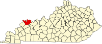
Henderson County is a county in the U.S. state of Kentucky. The county is located in western Kentucky on the Ohio River across from Evansville, Indiana. As of the 2020 census, the population was 44,793. Its county seat is Henderson.

<span class="mw-page-title-main">North Decatur, Georgia</span> Place in Georgia, United States

North Decatur is an unincorporated community and census-designated place (CDP) in DeKalb County, Georgia, United States. The population was 18,511 in 2020.

<span class="mw-page-title-main">Henderson, Kentucky</span> City in Kentucky, United States

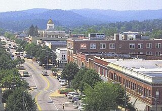
Henderson is a home rule-class city along the Ohio River and the county seat of Henderson County, Kentucky, United States. The population was 29,781 at the 2020 U.S. census. It is part of the Evansville–Henderson, IN–KY Combined Statistical Area, locally known as the "Tri-State Area," and is considered the southernmost suburb of Evansville, Indiana.

<span class="mw-page-title-main">Hendersonville, North Carolina</span> City in North Carolina, United States

Hendersonville is a city in and the county seat of Henderson County, North Carolina, United States, located 22 miles (35 km) south of Asheville. Like the county, the city is named for 19th-century North Carolina Supreme Court Chief Justice Leonard Henderson.

<span class="mw-page-title-main">Hamilton Heights, Manhattan</span> Neighborhood in New York City

Hamilton Heights is a neighborhood in the northern part of Manhattan in New York City. It is the northernmost part of the West Harlem area, along with Manhattanville and Morningside Heights to its south, and it contains the sub-neighborhood and historic district of Sugar Hill. Washington Heights lies to Hamilton Heights' north, and to its east is Central Harlem.

<span class="mw-page-title-main">Neighborhoods in Boston</span>

Boston's diverse neighborhoods serve as a political and cultural organizing mechanism. The City of Boston's Office of Neighborhood Services has designated 23 Neighborhoods in the city:

Audubon is a neighborhood in Louisville, Kentucky, United States. Its boundaries are Clarks Lane to the north, Poplar Level Road to the east, Preston Highway to the west, and the city of Audubon Park to the south. The smaller city of Parkway Village is surrounded by Audubon. George Rogers Clark Park, the site of a cabin owned by the parents of George Rogers Clark, is a prominent feature of the neighborhood.

<span class="mw-page-title-main">John James Audubon State Park</span> United States historic place

John James Audubon State Park is located on U. S. Route 41 in Henderson, Kentucky, just south of the Ohio River. Its inspiration is John James Audubon, the ornithologist, naturalist, and painter who resided in Henderson from 1810 to 1819 when Henderson was a frontier village.

The Henderson Gleaner is the daily newspaper in Henderson, Kentucky. The newspaper is published Tuesday through Sunday mornings. It has not been published on Mondays since it was founded in the 1880s.

Columbus, the state capital and Ohio's largest city, has numerous neighborhoods within its city limits. Neighborhood names and boundaries are not officially defined. They may vary or change from time to time due to demographic and economic variables.

Tri-Fest is an annual charitable festival held every April in Henderson, Kentucky. Established in 1988, it's one of the largest annual festivals held in Kentucky and generates over $100,000 in annual direct and indirect support to charities in western Kentucky and southern Indiana. The Henderson Breakfast Lions Club originated and continues to organize the festival as a means to raise funds for local charities. Tri-Fest raises funds for local charities in two ways:

  1. The Breakfast Lions Club generates revenue from the sale of tickets and concession booth fees to for-profit businesses. A portion of these funds are allocated to organize the following year's Tri-Fest. The bulk of this revenue, however, is donated to local charities.
  2. The organizers welcome local not-for-profit charities to set up food and educational booths. These charities keep 100% of their profits to support their organizations. Charities have included local schools, churches, an HIV care group, a local hospital, and other service, civic, and faith groups. Food items offered to Tri-Fest patrons have included pork chop sandwiches, lemonade, apple dumplings, corn dogs, hamburgers, and the dubious deep fried Twinkie.
<span class="mw-page-title-main">Bi-State Vietnam Gold Star Bridges</span> Twin-span cantilever bridge between Henderson, Kentucky, and Evansville, Indiana, USA

The Bi-State Vietnam Gold Star Twin Bridges,, are located in Henderson County, Kentucky and connect Henderson, Kentucky, and Evansville, Indiana, along U.S. Route 41 (US 41), two miles (3.2 km) south of the current southern terminus of Interstate 69 (I-69). The two bridges average more than 40,000 vehicles crossings a day across the Ohio River.

<span class="mw-page-title-main">National Register of Historic Places listings in Henderson County, Kentucky</span>

This is a list of the National Register of Historic Places listings in Henderson County, Kentucky.

<span class="mw-page-title-main">U.S. Route 41 in Kentucky</span> Section of U.S. Highway in Kentucky

U.S. Route 41 in the state of Kentucky is a north–south United States Numbered Highway that runs from Miami, Florida, to Copper Harbor, Michigan. In Kentucky, the highway is primarily paralleled by the Pennyrile Parkway and Interstate 69. It enters Kentucky in the Todd County community of Guthrie, and leaves the state north of Henderson into Evansville. The total length of US 41 through Kentucky is a total of 106.952 miles (172.123 km).

Weaverton is an unincorporated community and coal town located in Henderson, Kentucky, United States. This neighborhood is often referred to as the East End of the South Side of town today. Its boundaries are Loeb St to the east, Atkison St to the south, Madison St to the west, Mill St to the north, Pringle St to the west, Meadow St to the north connecting to the corner of Loeb St. Weaverton High School, now Weaverton Apartments, being the remaining site of this old unincorporated place is the territorial feature of this neighborhood area.

The Interstate 69 Ohio River Crossing is a planned bridge to carry the planned Interstate 69 (I-69) extension over the Ohio River between Evansville, Indiana, and Henderson, Kentucky. The bridge and its approach roadways make up a portion of Segment of Independent Utility 4 of the I-69 corridor from Michigan to Texas. It will be built approximately 1.62 miles (2.61 km) upstream of the existing Bi-State Vietnam Gold Star Bridges carrying U.S. Route 41 (US 41), at a point just downstream from where the Green River flows into the Ohio.

<span class="mw-page-title-main">Woodward Heights, Lexington</span> United States historic place

Woodward Heights is a neighborhood and historic district located immediately west of downtown Lexington, Kentucky. It is bounded by Maxwell Street and the Pleasant Green Hill neighborhood to the southwest, by the parking lot for Rupp Arena to the southeast, by the Lexington Convention Center property to the northeast, and by Herlihy, Cox, and High Streets to the north.

John A. Reitz (1815–1891), known as the "Lumber Baron," was an American entrepreneur, industrialist, banker, civic leader, and philanthropist in Evansville, Indiana. Using the wealth generated by his enterprises, he and his family created a lasting legacy of philanthropy in Evansville. Reitz gave millions of dollars to various charities, churches and educational organizations.

<span class="mw-page-title-main">Kentucky Route 54</span> State highway in Kentucky, United States

Kentucky Route 54 is a 54.329-mile-long (87.434 km) state highway in the U.S. state of Kentucky.

<span class="mw-page-title-main">Metzger's Tavern</span>

Metzger's Tavern is a historic bar, restaurant and package liquor store in the east side of Henderson, Kentucky. It is the oldest continuously operating tavern in the state of Kentucky. In 2010, Metzger's Tavern was named one of Huffington Post's top 25 dive bars in the United States.

References

  1. Arnett, Maralea. "Audubon". hendersonkyhistory.com. Henderson County Historical & Genealogical Society. Retrieved January 20, 2011.
  2. Stinnett, Chuck. "Christmas 50 years ago: Henderson was changing in 1960, but traditions continued as well". thegleaner.com. Evansville Courier & Press. Archived from the original on March 16, 2012. Retrieved January 20, 2011.
  3. "South Heights Elementary School".
  4. "School Information & Ratings on SchoolFinder".
  5. "Audubon Area Community Services Inc".
  6. John James Audubon Henderson County KY Biography. Hendersonkyhistory.com (1996-03-30). Retrieved on 2011-01-20.
  7. Susan Sommers Thurman (May 26, 2008). Henderson. Arcadia Publishing. pp. 38–. ISBN   978-0-7385-5355-9 . Retrieved January 20, 2011.
  8. "Thomas Bellew Obituary - Henderson, Kentucky - Tributes.com". Hosting-5714.tributes.com. Retrieved October 9, 2022.
  9. United States Official Postal Guide. Geo. F. Lasher. January 1892. p. 18.
  10. Boyett, Frank. "District 4 Magisterial mystery tour". thegleaner.com. Evansville Courier & Press. Archived from the original on March 16, 2012. Retrieved January 20, 2011.
  11. 1 2 3 Stinnett, Chuck. "The East End: 'Firehouse Willie' recalls the glory days of city's old working-class neighborhood". courierpress.com. Evansville Courier & Press. Retrieved October 23, 2017.
  12. "Eleventh Representative District". lrc.ky.gov. Kentucky Legislative Research Commission. Archived from the original on October 5, 2013. Retrieved March 2, 2024.
  13. "Fiscal Court - Staff - Henderson County Kentucky". Archived from the original on September 24, 2015. Retrieved October 5, 2013.
  14. 1 2 "Yesterday's News Frank Boyett".
  15. "Audubon Heights, Henderson, KY Real Estate & Homes for Sale".
  16. "Polling places listed » Evansville Courier & Press". Archived from the original on October 7, 2013. Retrieved October 5, 2013.