Auriac-Lagast

Last updated

Auriac-Lagast
Auriac-Lagast Entry.JPG
The road into Auriac-Lagast
Location of Auriac-Lagast
Auriac-Lagast
France location map-Regions and departements-2016.svg
Red pog.svg
Auriac-Lagast
Languedoc-Roussillon-Midi-Pyrenees region location map.svg
Red pog.svg
Auriac-Lagast
Coordinates: 44°08′50″N2°34′52″E / 44.1472°N 2.5811°E / 44.1472; 2.5811
Country France
Region Occitania
Department Aveyron
Arrondissement Millau
Canton Monts du Réquistanais
Intercommunality CC Réquistanais
Government
  Mayor (20202026) Yves Latieule [1]
Area
1
30.76 km2 (11.88 sq mi)
Population
 (Jan. 2021) [2]
229
  Density7.4/km2 (19/sq mi)
Time zone UTC+01:00 (CET)
  Summer (DST) UTC+02:00 (CEST)
INSEE/Postal code
12015 /12120
Elevation574–930 m (1,883–3,051 ft)
(avg. 680 m or 2,230 ft)
1 French Land Register data, which excludes lakes, ponds, glaciers > 1 km2 (0.386 sq mi or 247 acres) and river estuaries.

Auriac-Lagast is a commune in the Aveyron department in the Occitanie region of southern France.

Contents

Geography

A street in Auriac-Lagast Auriac-Lagast Street.JPG
A street in Auriac-Lagast

Auriac-Lagast is located some 27 km south of Rodez and 35 km north by north-east of Carmaux. Access to the commune is by the D522 road from Cassagnes-Bégonhès in the north-west, which passes through the heart of the commune and the village and continues south-east to Durenque. The D25 passes inside the eastern border of the commune as it goes from Salmiech to Villefranche-de-Panat. Apart from the village, there are the hamlets of:

The commune is almost entirely farmland with a few forests. [3]

The Gladou river rises in the east of the commune and flows west, forming part of the western border as it then flows north to join the Céar south of Cassagnes-Bégonhès. The Hunargues and the Ruisseau des Gazelles also rise in the commune and flow west to join the Gladou in the commune. The Ruisseau du Lagast rises in the south-eastern corner of the commune and forms most of the eastern border as it flows north to join the Céor. The Ruisseau de Miège Sole crosses the eastern arm of the commune and forms part of the northern border of the arm before continuing north to join the Ruisseau du Lagast just north of the commune. [3]

Neighbouring communes and villages

[3]

Administration

Auriac-Lagast Community Hall Auriac-Lagast Community Hall.JPG
Auriac-Lagast Community Hall

List of Successive Mayors [4]

FromToName
18331837Etienne Moudon
18371838Adolphe Bonnefous
18381848Hercule Bonnefous
18481853Marie Henri Régis Bonnefous
18531865Raymond Seguret
18651883Henri Urbain Molnier
20012008Yves Letieule
20082014Jean Garrigues
20142026Yves Latieule

Demography

The inhabitants of the commune are known as Aurigastois or Aurigastoises in French. [5]

Historical population
YearPop.±% p.a.
1793 422    
1800 531+3.34%
1836 533+0.01%
1841 648+3.98%
1846 571−2.50%
1851 552−0.67%
1856 527−0.92%
1861 538+0.41%
1866 585+1.69%
1872 616+0.86%
1876 583−1.37%
1881 614+1.04%
1886 600−0.46%
1891 612+0.40%
1896 620+0.26%
1901 615−0.16%
1906 617+0.06%
YearPop.±% p.a.
1911 608−0.29%
1921 584−0.40%
1926 593+0.31%
1931 636+1.41%
1936 659+0.71%
1946 652−0.11%
1954 558−1.93%
1962 524−0.78%
1968 524+0.00%
1975 425−2.95%
1982 385−1.40%
1990 315−2.48%
1999 280−1.30%
2007 262−0.83%
2012 234−2.24%
2017 229−0.43%
Source: EHESS [6] and INSEE [7]
Auriac-Lagast War Memorial Auriac-Lagast War Memorial.JPG
Auriac-Lagast War Memorial

Distribution of Age Groups

Auriac-Lagast General View Auriac-Lagast General View.JPG
Auriac-Lagast General View

Percentage Distribution of Age Groups in Auriac-Lagast and Aveyron Department in 2017

Auriac-LagastAveyron
Age RangeMenWomenMenWomen
0 to 14 Years151716.114.7
15 to 29 Years12614.612.3
30 to 44 Years151416.615.9
45 to 59 Years302421.320.5
60 to 74 Years161820.120.1
75 to 89 Years122110.213.8
90 Years+111.12.7

Source: INSEE [7] [8]

Sites and monuments

The Church of Saint-Leonard of Auriac Auriac-Lagast Church.JPG
The Church of Saint-Léonard of Auriac

See also

Bibliography

Related Research Articles

<span class="mw-page-title-main">Alrance</span> Commune in Occitanie, France

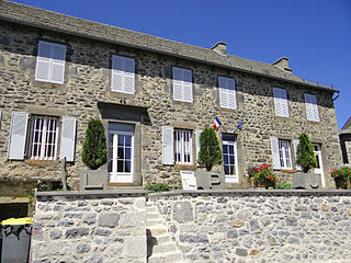
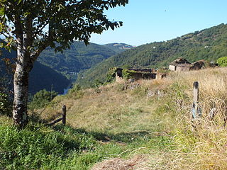
Alrance is a commune in the Aveyron department in the Occitanie region of southern France.

<span class="mw-page-title-main">Appy, Ariège</span> Commune in Occitanie, France

Appy is a commune in the Ariège department in the Occitanie region of southwestern France.

<span class="mw-page-title-main">Axiat</span> Commune in Occitanie, France

Axiat is a commune in the Ariège department in the Occitanie region of southwestern France.

<span class="mw-page-title-main">Les Albres</span> Commune in Occitanie, France

Les Albres is a commune in the Aveyron department in the Occitanie region of southern France.

<span class="mw-page-title-main">Alpuech</span> Part of Argences-en-Aubrac in Occitanie, France

Alpuech is a former commune in the Aveyron department in the Occitanie region of southern France. On 1 January 2016, it was merged into the new commune of Argences-en-Aubrac.

<span class="mw-page-title-main">Ambeyrac</span> Commune in Occitanie, France

Ambeyrac is a commune in the Aveyron department in the Occitanie region of southern France.

<span class="mw-page-title-main">Arnac-sur-Dourdou</span> Commune in Occitanie, France

Arnac-sur-Dourdou is a commune in the Aveyron department in the Occitanie region of southern France.

<span class="mw-page-title-main">Arques, Aveyron</span> Commune in Occitanie, France

Arques is a commune in the Aveyron department in the Occitanie region of southern France.

<span class="mw-page-title-main">Arvieu</span> Commune in Occitanie, France

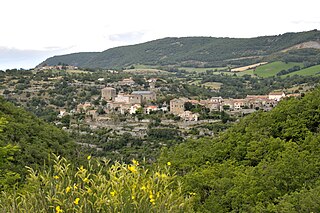
Arvieu is a commune in the Aveyron department in the Occitanie region of southern France.

<span class="mw-page-title-main">Asprières</span> Commune in Occitanie, France

Asprières is a commune in the Aveyron department in the Occitanie region of southern France.

<span class="mw-page-title-main">Aubin, Aveyron</span> Commune in Occitanie, France

Aubin is a commune in the Aveyron department in the Occitanie of southern France.

<span class="mw-page-title-main">Aurelle-Verlac</span> Part of Saint-Geniez-dOlt-et-dAubrac in Occitanie, France

Aurelle-Verlac is a former commune in the Aveyron department in the Occitanie region of southern France. On 1 January 2016, it was merged into the new commune of Saint-Geniez-d'Olt-et-d'Aubrac.

<span class="mw-page-title-main">Auzits</span> Commune in Occitanie, France

Auzits is a commune in the Aveyron department in the Occitanie region of southern France.

<span class="mw-page-title-main">Ayssènes</span> Commune in Occitanie, France

Ayssènes is a commune in the Aveyron department in the Occitanie region of southern France.

Balaguier-d'Olt is a commune in the Aveyron department in the Occitanie region of southern France.

Balsac is a village in the Aveyron department in the Occitanie region of southern France. It was merged into the new commune of Druelle Balsac on 1 January 2017.

<span class="mw-page-title-main">Baraqueville</span> Commune in Occitanie, France

Baraqueville is a commune in the Aveyron department in the Occitanie region of southern France.

<span class="mw-page-title-main">La Bastide-l'Évêque</span> Part of Le Bas Ségala in Occitanie, France

La Bastide-l'Évêque is a former commune in the Aveyron department in the Occitanie region of southern France. On 1 January 2016, it was merged into the new commune of Le Bas Ségala.

<span class="mw-page-title-main">La Bastide-Pradines</span> Commune in Occitanie, France

La Bastide-Pradines is a commune in the Aveyron department in the Occitanie region of Southern France. As of 2020, it had a population of 113.

La Bastide-Solages is a commune in the Aveyron department in the Occitanie region of Southern France. Located on the departmental border with Tarn, it had a population of 104 as of 2020.

References