Avan-Arinj

Last updated

Coordinates: 40°13′21″N44°34′13″E / 40.22250°N 44.57028°E / 40.22250; 44.57028

Geographic coordinate system Coordinate system

A geographic coordinate system is a coordinate system that enables every location on Earth to be specified by a set of numbers, letters or symbols. The coordinates are often chosen such that one of the numbers represents a vertical position and two or three of the numbers represent a horizontal position; alternatively, a geographic position may be expressed in a combined three-dimensional Cartesian vector. A common choice of coordinates is latitude, longitude and elevation. To specify a location on a plane requires a map projection.

Avan-Arinj
Armenia adm location map.svg
Red pog.svg
Avan-Arinj
Coordinates: 40°13′21″N44°34′13″E / 40.22250°N 44.57028°E / 40.22250; 44.57028
Country Armenia
Marz (Province) Yerevan
District Avan
Time zone   (UTC+4)

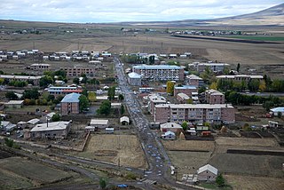
Avan-Arinj (Armenian : Ավան-Առինջ), is a neighbourhood in the Avan District of Yerevan, Armenia.

Armenian language Indo-European language

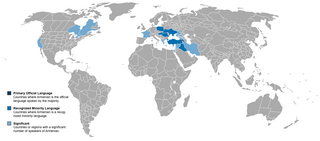
The Armenian language is an Indo-European language spoken primarily by Armenians. It is the official language of Armenia. Historically being spoken throughout the Armenian Highlands, today, Armenian is widely spoken throughout the Armenian diaspora. Armenian is written in its own writing system, the Armenian alphabet, introduced in 405 AD by Mesrop Mashtots.

Avan District Place in Yerevan, Armenia

Avan, is one of the 12 districts of Yerevan, the capital of Armenia. With an estimated population of 51,000, Avan forms the northern gate of Yerevan. Originally, an ancient village on a hill at the northeastern outskirts of Yerevan, Avan was inhabited since pre-Christian times. In the 20th century, during the Soviet rule, the village was incorporated to become part of the capital Yerevan. According to the 2011 census, Avan has a population of 53,231.

Yerevan City in Armenia

Yerevan is the capital and largest city of Armenia as well as one of the world's oldest continuously inhabited cities. Situated along the Hrazdan River, Yerevan is the administrative, cultural, and industrial center of the country. It has been the capital since 1918, the fourteenth in the history of Armenia and the seventh located in or around the Ararat plain. The city also serves as the seat of the Araratian Pontifical Diocese; the largest diocese of the Armenian Apostolic Church and one of the oldest dioceses in the world.

Related Research Articles

Byureghavan Place in Kotayk, Armenia

Byureghavan, is a town and urban municipal community in the Kotayk Province of Armenia. It is located 16 kilometres northeast of Yerevan, and 25 kilometres south of the provincial center Hrazdan. It covers an area of 4 square kilometres. The rural communities of Nurnus and Arzni form the northern and southern borders of the town respectively. As of the 2011 census, the population of the town is 9,513. Currently, the town has an approximate population of 8,300 as per the 2016 official estimate.

Linfield, Pennsylvania Unincorporated Village in Pennsylvania, United States

Linfield is an unincorporated village, part of Limerick Township, Montgomery County, Pennsylvania. It is located approximately 35 miles north-west of Philadelphia, along the Schuylkill River.

Arinj Place in Kotayk, Armenia

Arinj, is a major village in the Kotayk Province of Armenia. The Town is an upscale suburb located just north of Yerevan, with several multimillionaires having their Mansions located there including Gagik Tsarukyan, the founder of the Prosperous Armenia party. The village is 41 km south of the provincial capital Hrazdan. As of the 2011 census, the population of the village is 6,220.

Gegharot Place in Aragatsotn, Armenia

Gegharot is a town in the Aragatsotn Province of Armenia.

Hartavan Place in Aragatsotn, Armenia

Hartavan is a town in the Aragatsotn Province of Armenia.

Hatsavan, Kotayk Place in Kotayk, Armenia

Hatsavan is a town in the Kotayk Province of Armenia.

Nor Nork District Place in Yerevan, Armenia

Nor Nork, is one of the 12 districts of Yerevan, the capital of Armenia. It is located at the eastern part of the city. It is bordered by the districts of Nork-Marash, Kentron and Kanaker-Zeytun from the west, Avan from the north and Erebuni from the south. Kotayk Province forms the eastern border of the district.

Saramej Place in Lori Province, Armenia

Saramej is a town in the Lori Province of Armenia.

Tsaghkahovit Place in Aragatsotn, Armenia

Tsaghkahovit, known as Haji Khalil until 1946, is a village in the Aragatsotn Province of Armenia. There are many Late Bronze Age remains which are in the process of being excavated.

Tsapatagh Place in Gegharkunik, Armenia

Tsapatagh, is a small resort-village in the Gegharkunik Province of Armenia, on the south-eastern shore of Lake Sevan.

Vardablur, Aragatsotn Place in Aragatsotn, Armenia

Vardablur is a town in the Aragatsotn Province of Armenia.

Avan, Armenia Place in Aragatsotn, Armenia

Avan is a village in the Aragatsotn Province of Armenia. The population of the village is mainly Armenian. It is home to the basilica-style church of Surb Astvatsatsin that sits along a street just off the main road beside the main cemetery. The large cemetery contains many khachkars from the 13th to 18th centuries. Adjacent to it across the street is a stepped plinth and broken funerary pillar monument of the 5th to 6th centuries. A worn inscription may be found along the landings of the second and third steps. There is a newly built church also by the name of Surb Astvatsatsin that sits near the main highway closer to the centre of the village, and is said to have been constructed upon old foundations. Some confusion may arise since two churches in the village are referred to as S. Astvatsatsin, but one of them may be the church of S. Hovhannes. They are said to have been first built in the 5th to 6th centuries, were reconstructed in the 13th century, and have sat in ruins until recently since the earthquake of 1679.

Lucin, Pomeranian Voivodeship Settlement in Pomeranian, Poland

Lucin is a settlement in the administrative district of Gmina Wicko, within Lębork County, Pomeranian Voivodeship, in northern Poland. It lies approximately 9 kilometres (6 mi) north of Wicko, 24 km (15 mi) north-west of Lębork, and 81 km (50 mi) north-west of the regional capital Gdańsk.

Požeženo Village in Braničevo District, Serbia

Požeženo is a village in the municipality of Veliko Gradište, Serbia. According to the 2002 census, the village has a population of 799 people.

Getar River river in Armenia

Getar (Գետառ), formerly spelled Gedar, is a small river in Armenia that flows through Kotayk Province and central parts of the capital Yerevan. It originates near the village of Mayakovski at the western parts of Gegham mountains, flows through Avan-Arinj and joins Hrazdan River at the outskirts of Yerevan. Its length is about 24 kilometres (15 mi).

Khnusik Place in Aragatsotn, Armenia

Khnusik, is a village in the Aragatsotn Province of Armenia. It is part of the Avan community.

Crisis Management State Academy

Crisis Management State Academy is a state-owned public academy in Yerevan, Armenia. Founded in 1992, the academy is committed to training professionals in fire protection, rescue missions machinery, risk management, security operations, civil defense and rescue operations, offering bachelor's and master's degree programs.

Diocese of Kotayk Armenian Apostolic diocese

Diocese of Kotayk, is a diocese of the Armenian Apostolic Church covering the Kotayk Province of Armenia. The name is derived from the historic Kotayk canton of Ayrarat province of Armenia Major.

References