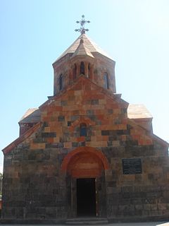
Nerkin Charbakh

Last updated

Coordinates: 40°07′45″N44°26′50″E / 40.12917°N 44.44722°E / 40.12917; 44.44722

Geographic coordinate system Coordinate system

A geographic coordinate system is a coordinate system that enables every location on Earth to be specified by a set of numbers, letters or symbols. The coordinates are often chosen such that one of the numbers represents a vertical position and two or three of the numbers represent a horizontal position; alternatively, a geographic position may be expressed in a combined three-dimensional Cartesian vector. A common choice of coordinates is latitude, longitude and elevation. To specify a location on a plane requires a map projection.

Nerkin Charbakh

Surb Khach Church Nerkin Charbakh 31.12.2014.JPG

Surb Khach Church
Armenia adm location map.svg
Red pog.svg
Nerkin Charbakh
Coordinates: 40°07′45″N44°26′50″E / 40.12917°N 44.44722°E / 40.12917; 44.44722
Country Armenia
Marz (Province) Yerevan
District Shengavit
Founded 1924
Time zone   (UTC+4)
  Summer (DST)  (UTC+5)

Nerkin Charbakh (Armenian : Ներքին Չարբախ), (also, Nerkin Ch’arbakh and Nizhniy Charbakh) is a part of Shengavit District in Yerevan, Armenia.
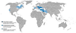
Armenian language Indo-European language

The Armenian language is an Indo-European language spoken primarily by Armenians. It is the official language of Armenia. Historically being spoken throughout the Armenian Highlands, today, Armenian is widely spoken throughout the Armenian diaspora. Armenian is written in its own writing system, the Armenian alphabet, introduced in 405 AD by Mesrop Mashtots.

Shengavit District Place in Yerevan, Armenia

Shengavit, is one of the 12 districts of Yerevan, the capital of Armenia, located at the southwestern part of the city. It has common borders with the districts of Malatia-Sebastia, Kentron, Erebuni and Nubarashen. Ararat Province forms the southern borders of the district.

Yerevan City in Armenia

Yerevan is the capital and largest city of Armenia as well as one of the world's oldest continuously inhabited cities. Situated along the Hrazdan River, Yerevan is the administrative, cultural, and industrial center of the country. It has been the capital since 1918, the fourteenth in the history of Armenia and the seventh located in or around the Ararat plain. The city also serves as the seat of the Araratian Pontifical Diocese; the largest diocese of the Armenian Apostolic Church and one of the oldest dioceses in the world.
Related Research Articles

Arevshat Place in Ararat, Armenia

Arevshat is a village in the Ararat province of Armenia.

Khoronk Place in Armavir, Armenia

Khoronk is a town in the Armavir province of Armenia. The town's church dates to 1880.

Araks, Vagharshapat Place in Armavir, Armenia

Araks, known as Nerkin Karkhun and Sharifabad until 1946, is a village in the eastern part of the Armavir Province of Armenia.

Dimitrov, Armenia Place in Ararat, Armenia

Dimitrov is a village in the Ararat Province of Armenia.

Dzoragyugh, Aragatsotn Place in Aragatsotn, Armenia

Dzoragyugh ; was known as Pirtikan or Nerkin Pirtikan until 1940, is a village in the Aragatsotn Province of Armenia. The village is part of the Mastara community.

Gyulludara Place in Lori Province, Armenia

Gyulludara, is a former village in the Lori Province of Armenia.

Aknaghbyur Place in Tavush, Armenia

Aknaghbyur is a town in the Tavush Province of Armenia. Aknaghbyur was founded in 451 in honor of Vartan Mamikonian and is one of Armenia’s oldest rural communities. In recent years, ArmeniaFund has launched and completed several vital projects on the infrastructure of the town, such as the construction of a gas pipeline and an irrigation system and the renovation of the drinking-water system.

Nerkin Bazmaberd Place in Aragatsotn, Armenia

Nerkin Bazmaberd is a town in the Aragatsotn Province of Armenia. The population descends from refugees from Western Armenia in 1915.

Nerkin Karmiraghbyur Place in Tavush, Armenia

Nerkin Karmiraghbyur (Armenian: Ներքին Կարմիրաղբյուր, also Romanized as Nerkin Karmiraghpyur, is a village in the Tavush Province of Armenia.

Nerkin Khatunarkh Place in Ararat, Armenia

Nerkin Khatunarkh is a town in the Ararat Province of Armenia.

Nerkin Nedzhirlu Place in Ararat, Armenia

Nerkin Nedzhirlu is a town in the Ararat Province of Armenia.

Nerkin Sasnashen Place in Aragatsotn, Armenia

Nerkin Sasnashen ; formerly known as Nerkin Karakoymaz and Nerkin Sasunashen, is a village in the Aragatsotn Province of Armenia. It is home to the ruins of a 7th-century Armenian monastery. The village contains a granite memorial marking the crash site of a United States Air Force C-130 shot down by Soviet MiG-17s on 2 September 1958 with the loss of 17 U.S. personnel.

Nerkin Shengavit Place in Yerevan, Armenia

Nerkin Shengavit is a part of Shengavit District in Yerevan, Armenia.

Nerkin Shorzha Place in Gegharkunik, Armenia

Nerkin Shorzha is a small hamlet in the Gegharkunik Province of Armenia. Nerkin Shorzha and nearby Verin Shorzha are both reached by a short drive from Ayrk.

Vahramaberd Place in Shirak, Armenia

Vahramaberd is a village in the Shirak Province of Armenia.

Verin Charbakh Place in Yerevan, Armenia

Verin Charbakh is a part of Shengavit District in Yerevan, Armenia.

Dvin, Armenia Place in Ararat, Armenia

Dvin is a village in the Ararat Province of Armenia. It is located near the ruins of the ancient city of Dvin.

Charbakh may refer to:

Shengavit (Yerevan Metro) Yerevan Metro Station

Shengavit, is a Yerevan Metro station. It was opened to public on December 26, 1985. Located on Soghomon Tarontsi street within the Artur Karapetyan park, the station serves the Shengavit District.

References