
The Parts of Kesteven are a traditional division of Lincolnshire, England. This division had long had a separate county administration, along with the two other Parts of Lincolnshire, Lindsey and Holland.

Morton and Hanthorpe is a civil parish, formerly known as Morton by Bourne in the South Kesteven district of Lincolnshire, England. It is situated 2 miles (3 km) north from Bourne, and 14 miles (23 km) south-east from Grantham. According to the 2011 Census the parish had a population of 2,406.
Dowsby is a village and civil parish in the South Kesteven district of Lincolnshire, England. It is situated on the western edge of The Fens at the junction of the east–west B1397 road and the north–south B1177. It is 1 mile (1.6 km) north-east from Rippingale and just south of Pointon. The civil parish includes the hamlet of Graby. Nearby to the east, along the B1397 at Dowsby Fen, is Car Dyke. The civil parish population taken at the 2011 census was 204.

Thurlby is a village and civil parish in the South Kesteven district of Lincolnshire, England. It is situated just west of the A15 road, 2 miles (3 km) south from the town of Bourne, and on the edge of the Lincolnshire Fens. It is sometimes referred to as Thurlby by Bourne to distinguish it from other villages in Lincolnshire with the same name. Thurlby and the hamlet of Northorpe to its north are conjoined. The parish had a population of 2,136 at the 2001 census and 2,153 at the 2011 census.

Aslackby and Laughton is a civil parish in the South Kesteven district of Lincolnshire, England. According to the 2001 census the parish had a population of 243, in 102 households. increasing slightly to 251 in 118 households at the 2011 census. It consists of the village of Aslackby, the hamlet of Laughton, and scattered farms, and part of the hamlet of Graby.

Aunsby and Dembleby is a civil parish in the North Kesteven district of Lincolnshire, England. According to the 2001 Census it had a population of 125. The parish includes Aunsby and Dembleby, which were separate parishes until 1931, and the hamlet of Scott Willoughby.

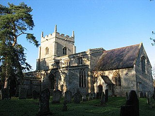
Billingborough is a village and civil parish in the South Kesteven district of Lincolnshire, England. It is situated approximately 10 miles (16 km) north of Bourne and 10 miles south of Sleaford, and on the B1177 between Horbling and Pointon just south of the A52.

Bottesford is a town in North Lincolnshire, Lincolnshire, England.

Braceborough is a village in the South Kesteven district of Lincolnshire, England. It is situated off the Stamford to Bourne A6121 road, just west of the A15 as it runs between Market Deeping and Bourne. It forms part of the Civil Parish of Braceborough and Wilsthorpe.

Greatford is a village and civil parish in the South Kesteven district of Lincolnshire, England. It is situated 2 miles (3 km) west from the A15, 4.5 miles (7 km) north-east from Stamford, and 5 miles (8 km) south from Bourne. Greatford is noted for Greatford Hall, once the home of Francis Willis.
Willoughton is a village and civil parish in the West Lindsey district of Lincolnshire, England. It is situated 2 miles (3.2 km) west from the A15 road, 13 miles (21 km) north from Lincoln and 3 miles (5 km) south from Kirton Lindsey. According to the 2001 Census the village had a population of 330, increasing to 341 at the 2011 census.

Wyville is a village in the civil parish of Wyville cum Hungerton, in the South Kesteven district of Lincolnshire, England, and situated approximately 5 miles (8 km) south-west from Grantham The whole parish covers about 1,670 acres (6.8 km2). The population is included in the civil parish of Little Ponton and Stroxton.

Swayfield is a village and civil parish in the South Kesteven district of Lincolnshire, England. The population of the civil parish at the 2011 census was 316. It is situated just over 3 miles (5 km) east from the A1 road, 9 miles (14 km) south-east from Grantham and 10 miles (16 km) north from Stamford. It has approximately 138 houses.

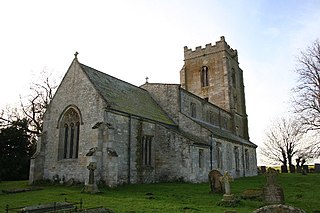
Rippingale is a village and civil parish in the South Kesteven district of Lincolnshire, England. The population of the civil parish was 929 at the 2011 census. The village is situated on the A15 road, about 5 miles (8 km) north from Bourne.
Ingoldsby is a small village in the South Kesteven district of Lincolnshire, England. It is situated 7 miles (11 km) south-east from the market town of Grantham, 32 miles (51 km) south of the county town of Lincoln, and 33 miles (53 km) east of the City of Nottingham. The village contains approximately 121 households.

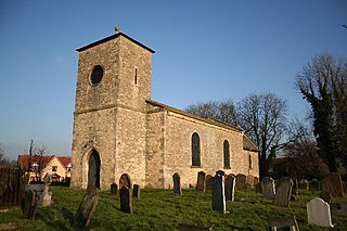
Dunsby is a small village and civil parish in the South Kesteven district of in Lincolnshire, England. It is 4 miles (6.4 km) north from Bourne, just east off the A15, and on the western edge of the Lincolnshire Fens. In 2001 it had a population of 141, reducing to 122 at the 2011 census.
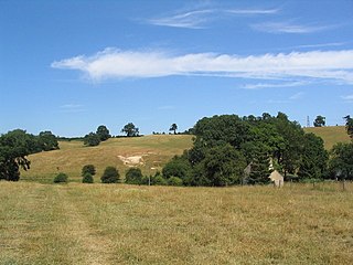
Careby Aunby and Holywell is a civil parish in the district of South Kesteven, south-west Lincolnshire, in England. It stretches from the county border with Rutland in the west to the River West Glen in the east. The B1176 road from Corby Glen passes through Careby and on past Aunby toward Stamford. The main London to Scotland railway line passes through the parish, the line upon which Mallard took the speed record for the LNER.

Walcot is a village and civil parish in the North Kesteven district of Lincolnshire, England. It lies 1 mile (1.6 km) west from the A15, 7 miles (11 km) south from Sleaford, 9 miles (14 km) east from Grantham, and 1 mile north from Folkingham. The population is included in the civil parish of Newton and Haceby.

The first elections to Kesteven County Council were held on Thursday, 17 January 1889. Kesteven was one of three divisions of the historic county of Lincolnshire in England; it consisted of the ancient wapentakes of Aswardhurn, Aveland, Beltisloe, Boothby Graffoe, Flaxwell, Langoe, Loveden, Ness, and Winnibriggs and Threo. The Local Government Act 1888 established Kesteven as an administrative county, governed by a Council; elections were held every three years from 1889, until it was abolished by the Local Government Act 1972, which established Lincolnshire County Council in its place.
Elections to Kesteven County Council were held on Saturday, 9 April 1949. Kesteven was one of three divisions of the historic county of Lincolnshire in England; it consisted of the ancient wapentakes of Aswardhurn, Aveland, Beltisloe, Boothby Graffoe, Flaxwell, Langoe, Loveden, Ness, and Winnibriggs and Threo. The Local Government Act 1888 established Kesteven as an administrative county, governed by a Council; elections were held every three years from 1889, until it was abolished by the Local Government Act 1972, which established Lincolnshire County Council in its place.

