
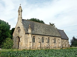
Haddington is a hamlet in the civil parish of Aubourn with Haddington, in the North Kesteven district of Lincolnshire, England. It is situated just off the Fosse Way Roman road, now the A46, 7 miles (11 km) south-west from Lincoln and 1 mile (1.6 km) west from Aubourn. Haddington was formerly a township in the parishes of Aubourn and South Hyckham, in 1866 Haddington became a separate civil parish, on 1 April 1931 the parish was abolished to form "Aubourn, Haddington and South Hykeham". In 1921 the parish had a population of 94.

Sempringham is a hamlet in the South Kesteven district of Lincolnshire, England. It is situated 2 miles (3.2 km) south from the A52 road, 12 miles (19 km) east from Grantham and 8 miles (13 km) north from Bourne. The hamlet is in the civil parish of Pointon and Sempringham, and on the western edge of the Lincolnshire Fens, the closest village being Billingborough, 0.5 miles (0.80 km) to the north on the B1177 road. Sempringham is noted as the home of Gilbert of Sempringham, the son of the lord of the manor. Gilbert is the only English Saint to have founded a monastic order, the Gilbertines.

Ewerby is a village in the civil parish of Ewerby and Evedon, in the North Kesteven district of Lincolnshire, England. It lies 3 miles (4.8 km) north-east from Sleaford and 2 miles (3.2 km) south from Anwick. The hamlet of Ewerby Thorpe lies 0.7 miles (1.1 km) to the east from Ewerby.

West Torrington is a small hamlet in the East Lindsey district of Lincolnshire, England. It is situated on the edge of Bleasby Moor and 3 miles (4.8 km) north from Wragby. The 2001 Census recorded a West Torrington population of 69, increasing to 128 at the 2011 census.

Asgarby is a village in the civil parish of Asgarby and Howell, in the North Kesteven district of Lincolnshire, England. It is situated on the A17 Boston to Newark road, 3 miles (5 km) east from Sleaford and 2 miles (3 km) north-west from Heckington. In 1921 the parish had a population of 63. On 1 April 1931 the parish was abolished to form "Asgarby and Howell".

Fosdyke is a village and civil parish in the Borough of Boston, Lincolnshire, England. The population of the civil parish at the 2011 census was 480. It is situated approximately 7 miles (11 km) south from Boston, just off the A17, and 2 miles (3.2 km) east from the junction of the A17 with the A16.

Birthorpe is a hamlet in the civil parish of Billingborough, in the South Kesteven district of Lincolnshire, England. It is situated less than 1 mile (2 km) west from Billingborough and the B1177 Pointon Road, and 2 miles (3 km) east from Folkingham. Birthorpe was formerly in the parish of Semperingham, in 1866 Birthorpe became a separate civil parish, on 1 April 1931 the parish was abolished and merged with Billingborough. In 1921 the parish had a population of 46.
Brothertoft is a village in the civil parish of Holland Fen with Brothertoft, in the Boston district, in the county of Lincolnshire, England. It is about 4 miles (6.4 km) northwest from the market town of Boston.
Gunby is a village and former civil parish, now in the parish of Gunby and Stainby, in the South Kesteven district of Lincolnshire, England. It is situated close to the borders with Leicestershire and Rutland, and 9 miles (14 km) south from Grantham, and 2 miles (3 km) west from the A1 road. In 1921 the parish had a population of 119. On 1 April 1931 the parish was abolished and merged with Stainby to form "Gunby and Stainby".

Sapperton is a village in the civil parish of Braceby and Sapperton, in the South Kesteven district of Lincolnshire, England. The nearest town is Grantham, 6 miles (9.7 km) to the west. Adjacent villages include Braceby, Pickworth and Ropsley. In 1921 the parish had a population of 46. On 1 April 1931 the parish was abolished and merged with Braceby to form "Braceby and Sapperton".

Keisby is a hamlet in the civil parish of Lenton, Keisby and Osgodby, in the South Kesteven district, in Lincolnshire, England. It is situated 6 miles (10 km) north-west from Bourne and 9 miles (14 km) south-east from Grantham. In 1921 the parish had a population of 72.

Cuxwold is a village and former civil parish, now in the parish of Swallow, in the West Lindsey district of Lincolnshire, England. It lies in the Lincolnshire Wolds, 4 miles (6 km) east from Caistor and 10 miles (16 km) south-west from Grimsby. In 1931 the parish had a population of 98. On 1 April 1936 the parish was abolished and merged with Swallow.

Lenton is a village in the civil parish of Lenton, Keisby and Osgodby, in the district of South Kesteven, Lincolnshire, England. It is situated approximately 7 miles (11 km) south-east from Grantham. In 1921 the parish had a population of 117. On 1 April 1931 the parish was abolished to form "Lenton Keisby and Osgodby".

Hagnaby is a small village and former civil parish, now in the parish of East Kirkby, in the East Lindsey district of Lincolnshire, England. It is 4 miles (6.4 km) south-west from Spilsby. In 1961 the parish had a population of 18. On 1 April 1987 the parish was abolished and merged with East Kirkby.

Doddington is a village in the civil parish of Doddington and Whisby, in the North Kesteven district of Lincolnshire, England. The population of the civil parish of "Doddington and Whisby" at the 2011 census was 319. The parish of Doddington and Whisby lies 5 miles (8 km) west of Lincoln, to the north of the A46 road, and is bounded to its west by Nottinghamshire. It includes the hamlet of Whisby, and parts of the Whisby Moor Nature Reserve.
Kelby is a village in the civil parish of Culverthorpe and Kelby, in the North Kesteven district of Lincolnshire, England. It lies 5 miles (8 km) south-west from Sleaford, 9 miles (14 km) north-east from Grantham and 3 miles (5 km) south-east from Ancaster. Kelby was formerly a chapelry in the parish of Haydor, in 1866 Kelby became a separate civil parish, on 1 April 1935 the parish was abolished and merged with Culverthorpe to form "Culverthorpe and Kelby". In 1921 the parish had a population of 61.

Culverthorpe is a hamlet in the civil parish of Culverthorpe and Kelby, in the North Kesteven district of Lincolnshire, England. It lies 5 miles (8 km) south-west from Sleaford, 9 miles (14 km) north-east from Grantham and 3 miles (5 km) south-east from Ancaster.

Evedon is a village in the civil parish of Ewerby and Evedon, in the North Kesteven district of Lincolnshire, England. It is situated 2 miles (3.2 km) north-east from the town of Sleaford.

Haceby is a village in the civil parish of Newton and Haceby in the district of North Kesteven, Lincolnshire, England. It is 8 miles (13 km) east from Grantham, 8 miles south from Sleaford, and 1 mile (1.6 km) south from the A52 road. In 1921 the parish had a population of 51. On 1 April 1931 the parish was abolished and merged with Newton to form "Newton and Haceby".

Walcot is a village and civil parish in the North Kesteven district of Lincolnshire, England. It lies 1 mile (1.6 km) west from the A15, 7 miles (11 km) south from Sleaford, 9 miles (14 km) east from Grantham, and 1 mile north from Folkingham. The population is included in the civil parish of Newton and Haceby.


