
Nedumangad is a municipal town in the Thiruvananthapuram district in the Indian state of Kerala. It is the headquarters of Nedumangad Tehsil and Nedumangad Revenue Division. It is a suburb of the extended metropolitan region of Thiruvananthapuram. It is located around 16 km (9.9 mi) to the north-east of Thiruvananthapuram on the State Highway 2. It is an important commercial center in the district. It is a growing commercial and educational hub and all important government institutions are situated in the town. The Nedumangadu market has significance in southern Kerala.
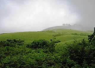
Vagamon is an Indian hill station and a revenue village located in Peerumedu Taluk of Idukki district, and also Meenachil taluk and Kanjirappally taluk of Kottayam district in the state of Kerala, India. Located in the Western Ghats 25 kilometres (16 mi) east of Erattupetta on the border of Kottayam-Idukki districts, Vagamon is famous for its natural beauty. The Vagamon glass bridge is the longest cantilever glass bridge in India.

Ulikkal is a growing town in Kannur District in Kerala. It is the HQ of Ulikkal Grama Panchayat in Iritty Taluk. Kerala State Hill highway SH 59 passes through Ulikkal Town.

Kalliasseri is a census town in Kannur district in the Indian state of Kerala. Kalliaseri Panchayat comprises two villages: Kalliasseri and Irinave.

Kumily, also spelt as Kumaly is a revenue village and Gram Panchayat in the Idukki district of the state of Kerala. It is a town in Cardamom Hills near Thekkady and Periyar Tiger Reserve. Kumily is a gateway town into Kerala from Tamil Nadu.
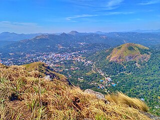
Kattappana ([kaʈ:ap:ɐna]) is a municipality in the Idukki district of Kerala, India. It is located 21 km (13.0 mi) southeast of the district headquarters in Painavu and about 140 km (87.0 mi) north of the state capital, Thiruvananthapuram. Kattappana is the second-largest municipality in the district by population, and serves as a major hub for commercial and economic activity for the surrounding region.

Kulathupuzha is a town in the eastern part of Kollam district of Kerala, India. It is one of the important pilgrim spots linked with the legend of Sabarimala. It is the birthplace of the Malayalam music composer Raveendran. Kulathupuzha is the source of the Kallada river, Thenmala Dam (KIP) is located on this river. As declared by the Governor Arif Mohammad Khan, Kulathupuzha panchayat is the first in India to have achieved Constitution-literacy.

Elappara is a town in Idukki district in the southwestern Indian state of Kerala. It is one of the panchayaths in Peerumedu taluk. The area is marked by a cool climate as the region is situated at an elevation of over 1,000 m (3,300 ft) above sea level. Elappara is famous for its vast tea plantations.

Karunapuram is a village in Idukki district in the Indian state of Kerala.
Rajakkad is a town in the Idukki district in the Indian state of Kerala situated in the Western Ghats.

Purathur is a sandy coastal village and a Grama Panchayat in Tirur Taluk, Malappuram district in the state of Kerala, India. Bharathappuzha river and Tirur River merges together in Purathur and join with the Arabian Sea at Padinjarekara Azhimukham, which is also the southernmost tip of Purathur Gram panchayat. Opposite to Padinjarekara Azhimukham is Ponnani port. The village is located at the southernmost tip of Tirur Taluk and is bordered by historically important Ponnani port in Ponnani Municipality of Ponnani taluk to south.
Thankamany is a town at Idukki district, in Kerala state, India. In regional language thankamany is a name of a lady. It is a belief that a king Thopran gave dowry as land for his three daughters Thankamany, Kamashi, and Neeli. The place got for Thankamony is now known as Thankamany, other nearby places are also known as Kamashi and Neelivayal. Thankamany town is located in a valley of three small hills Thamprankunnu, Kattadikavala and Kurishupara respectively. One of the interesting thing is that, even though Kamashi is a different place, the panchayath of thankamany is called Kamashy panchayath and the office is situated in the middle of thankamany town.Sometimes in official documents thankamany is also written as thankamony. Nearest towns are Kattappana and Nedumkandam.

Vandiperiyar, IPA:[ʋɐɳɖipːeɾijɐːr], is a spice village in Idukki district, in the Indian state of Kerala. It is known for tourism, tea and coffee plantations, black pepper and other spice products. It is also known as an educational city and a number of tea factories are situated in the town. The Periyar River flows through the town. Colleges: govt poly technic college. Schools : phss, st Joseph, high range, goodluck educations, govt upper primary, fathima school, govt lower primary, trinity garden.

Kanchiyar is a village located in Idukki taluk of Idukki district, Kerala, India. The place has a vast cardamom and pepper plantations. Anchuruli, one of the famous tourist spots in Idukki district is located in Kanchiyar panchayath. The main settlements in Kanchiyar are Kozhimala, Swaraj, Labbakkada, Thoppipala, Mattappally and Kakkattukada.

Anakkara is a geographic area of around 50 square kilometres that spreads across Vandanmedu, Chakkupallam Panchayats in the Udumbanchola Taluk of Idukki District, Kerala, India. Anakkara is the administrative capital of Chakkupallam Grama Panchayat and Anakkara Revenue Village. It is about 18 kilometers (11 mi) from Thekkady wildlife sanctuary on the Kumily-Munnar state highway.

Chapparapadavu is a Grama panchayat in Kannur district in the Indian state of Kerala. Chapparapadavu Panchayat have administration over the villages of Kooveri, Thimiri and Vellad.
Kolachery is a census town and Grama Panchayat in Kannur District of Kerala state, India. Kolachery is located 15 kilometres (9.3 mi) north east of Kannur city.
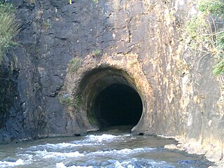
Anchuruli, also spelled Anjuruli, is a popular tourist destination located in Kanchiyar panchayat in Idukki district, Kerala state, India. Anchuruli is famous for the 5.5 km (3.4 mi) long circular tunnel that carries water from Erattayar dam to Idukki reservoir.

Erattayar Dam is a small, diversion dam built on the Erattayar river in Erattayar grama panchayat near Kattappana town in Idukki district of Kerala, India. It acts mainly as a diversion dam to supply water to the Idukki dam. Diversion of water from Erattayar forebay to Idukki reservoir is through a tunnel called Anchuruli tunnel which is 3.77 km (2.34 mi) long. Construction of the dam was completed in the year 1989.
Erattayar is a village in Udumbanchola taluk of Idukki district in the Indian state of Kerala. It is the administrative centre of Erattayar panchayat which belongs to Kattappana block panchayat.


