Siyəzən is a city and municipality in, and the capital of, the Siazan Rayon of Azerbaijan. It has a population of 24,900.

Nakseongdae Station is a station on Seoul Subway Line 2. This station is named after a nearby place called Nakseongdae (落星垈), which literally means 'the site of the fallen star' and is the birthplace of the great Goryeo general Gang Gam-chan, best known for his heroics against an invading Khitan force in the Battle of Gwiju.
Valley Downs is a neighborhood of Louisville, Kentucky, USA located along Omar Khayyam Boulevard south of Johnsontown Road.
Pęczków is a village in the administrative district of Gmina Środa Śląska, within Środa Śląska County, Lower Silesian Voivodeship, in south-western Poland. Prior to 1945 it was in Germany.

Szynwałdzik is a village in the administrative district of Gmina Łasin, within Grudziądz County, Kuyavian-Pomeranian Voivodeship, in north-central Poland. It lies approximately 7 kilometres (4 mi) north of Łasin, 25 km (16 mi) east of Grudziądz, and 69 km (43 mi) north-east of Toruń.
Zagajewice is a village in the administrative district of Gmina Dąbrowa Biskupia, within Inowrocław County, Kuyavian-Pomeranian Voivodeship, in north-central Poland. It lies approximately 8 kilometres (5 mi) north-west of Dąbrowa Biskupia, 16 km (10 mi) east of Inowrocław, and 25 km (16 mi) south-west of Toruń.

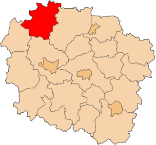
Przeczno is a village in the administrative district of Gmina Łubianka, within Toruń County, Kuyavian-Pomeranian Voivodeship, in north-central Poland. It lies approximately 17 km (11 mi) north-west of Toruń and 33 km (21 mi) east of Bydgoszcz.
Mikołajskie is a village in the administrative district of Gmina Cekcyn, within Tuchola County, Kuyavian-Pomeranian Voivodeship, in north-central Poland. It lies approximately 9 kilometres (6 mi) north-east of Cekcyn, 18 km (11 mi) east of Tuchola, and 57 km (35 mi) north of Bydgoszcz.
Sielpia Wielka is a village in the administrative district of Gmina Końskie, within Końskie County, Świętokrzyskie Voivodeship, in south-central Poland. It lies approximately 11 kilometres (7 mi) south-west of Końskie and 32 km (20 mi) north-west of the regional capital Kielce.
Trawno is a village in the administrative district of Gmina Fałków, within Końskie County, Świętokrzyskie Voivodeship, in south-central Poland.
Daniszów is a village in the administrative district of Gmina Lipsko, within Lipsko County, Masovian Voivodeship, in east-central Poland.
Nieradowo is a village in the administrative district of Gmina Szydłowo, within Mława County, Masovian Voivodeship, in east-central Poland. It lies approximately 8 kilometres (5 mi) east of Mława and 105 km (65 mi) north of Warsaw.

Katarzynki is a village in the administrative district of Gmina Swarzędz, within Poznań County, Greater Poland Voivodeship, in west-central Poland.
Lubieszynek is a village located in the administrative district of Gmina Nowa Karczma within Kościerzyna County, Pomeranian Voivodeship in northern Poland. It lies approximately 3 kilometres (2 mi) south of Nowa Karczma, 16 km (10 mi) east of Kościerzyna, and 40 km (25 mi) south-west of the regional capital Gdańsk.
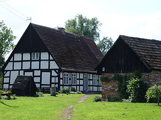
Swołowo is a village in the administrative district of Gmina Słupsk, within Słupsk County, Pomeranian Voivodeship, in northern Poland. It lies approximately 13 kilometres (8 mi) west of Słupsk and 117 km (73 mi) west of the regional capital Gdańsk.
Łukocin is a village in the administrative district of Gmina Tczew, within Tczew County, Pomeranian Voivodeship, in northern Poland. It lies approximately 4 kilometres (2 mi) north-west of Tczew and 29 km (18 mi) south of the regional capital Gdańsk.
Kamień is a village in the administrative district of Gmina Szemud, within Wejherowo County, Pomeranian Voivodeship, in northern Poland. It lies approximately 4 kilometres (2 mi) east of Szemud, 14 km (9 mi) south of Wejherowo, and 27 km (17 mi) north-west of the regional capital Gdańsk.
Jadwiżyn is a settlement in the administrative district of Gmina Bobolice, within Koszalin County, West Pomeranian Voivodeship, in north-western Poland.
Kullimaa is a village in Käru Parish, Rapla County in western-central Estonia.
Eerikulaid is an island belonging to the country of Estonia.