Clarendon Park is a settlement in Clarendon Parish in south-central Jamaica.
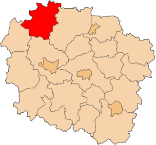
Świętosław is a village in the administrative district of Gmina Włocławek, within Włocławek County, Kuyavian-Pomeranian Voivodeship, in north-central Poland. It lies approximately 12 kilometres (7 mi) south-west of Włocławek and 59 km (37 mi) south-east of Toruń.
Pinino is a village in the administrative district of Gmina Rogowo, within Rypin County, Kuyavian-Pomeranian Voivodeship, in north-central Poland.
Kalitnik is a village in the administrative district of Gmina Michałowo, within Białystok County, Podlaskie Voivodeship, in north-eastern Poland, close to the border with Belarus.
Kuchmy-Kuce is a village in the administrative district of Gmina Michałowo, within Białystok County, Podlaskie Voivodeship, in north-eastern Poland, close to the border with Belarus.

Wierzbowa is a village in the administrative district of Gmina Wartkowice, within Poddębice County, Łódź Voivodeship, in central Poland. It lies approximately 5 kilometres (3 mi) east of Wartkowice, 13 km (8 mi) north-east of Poddębice, and 35 km (22 mi) north-west of the regional capital Łódź.
Kazimierzów is a village in the administrative district of Gmina Opole Lubelskie, within Opole Lubelskie County, Lublin Voivodeship, in eastern Poland.
Huta Nowa is a village in the administrative district of Gmina Bieliny, within Kielce County, Świętokrzyskie Voivodeship, in south-central Poland. It lies approximately 6 kilometres (4 mi) east of Bieliny and 27 km (17 mi) east of the regional capital Kielce.
Rzepin Pierwszy is a village in the administrative district of Gmina Pawłów, within Starachowice County, Świętokrzyskie Voivodeship, in south-central Poland. It lies approximately 3 kilometres (2 mi) north-west of Pawłów, 8 km (5 mi) south of Starachowice, and 35 km (22 mi) east of the regional capital Kielce.
Skuły is a village in the administrative district of Gmina Żabia Wola, within Grodzisk Mazowiecki County, Masovian Voivodeship, in east-central Poland. It lies approximately 15 kilometres (9 mi) south of Grodzisk Mazowiecki and 35 km (22 mi) south-west of Warsaw.
Sierzchów is a village in the administrative district of Gmina Góra Kalwaria, within Piaseczno County, Masovian Voivodeship, in east-central Poland. It lies approximately 7 kilometres (4 mi) west of Góra Kalwaria, 12 km (7 mi) south-east of Piaseczno, and 28 km (17 mi) south of Warsaw.
Długokąty Małe is a village in the administrative district of Gmina Puszcza Mariańska, within Żyrardów County, Masovian Voivodeship, in east-central Poland. It lies approximately 4 kilometres (2 mi) west of Puszcza Mariańska, 12 km (7 mi) south-west of Żyrardów, and 55 km (34 mi) south-west of Warsaw.
Biały Młyn is a village in the administrative district of Gmina Kępno, within Kępno County, Greater Poland Voivodeship, in west-central Poland. It lies approximately 3 kilometres (2 mi) north of Kępno and 143 km (89 mi) south-east of the regional capital Poznań.
Świeszyno is a village in Gmina Miastko, Bytów County, Pomeranian Voivodeship, in northern Poland. It lies approximately 21 kilometres (13 mi) south-west of Bytów and 68 km (42 mi) south-west of Gdańsk.
Grabice is a village in the administrative district of Gmina Murów, within Opole County, Opole Voivodeship, in south-western Poland.
Ostrowite is a village in the administrative district of Gmina Chojnice, within Chojnice County, Pomeranian Voivodeship, in northern Poland. It lies approximately 11 kilometres (7 mi) south-east of Chojnice and 104 km (65 mi) south-west of the regional capital Gdańsk.
Wygonki is a settlement in the administrative district of Gmina Czarne, within Człuchów County, Pomeranian Voivodeship, in northern Poland. It lies approximately 12 kilometres (7 mi) south-east of Czarne, 18 km (11 mi) west of Człuchów, and 129 km (80 mi) south-west of the regional capital Gdańsk.
Żabno is a village in the administrative district of Gmina Starogard Gdański, within Starogard County, Pomeranian Voivodeship, in northern Poland. It lies approximately 4 kilometres (2 mi) north-west of Starogard Gdański and 44 km (27 mi) south of the regional capital Gdańsk.
Kalmu is a village in Saaremaa Parish, Saare County in western Estonia.
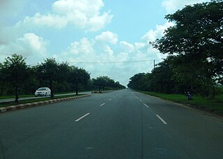
National Highway 1 (NR1), literally "The Road to Mandalay ") is an important south-north flowing highway of central Burma and the busiest road in the country. It connects Yangon to Meiktila where it joins the National Highway 4 going east and then NR1 continues north to Mandalay.