Starogard County is a unit of territorial administration and local government (powiat) in Pomeranian Voivodeship, northern Poland. The name is a combination of two terms: stari which is Slavic for old and gard which is Pomeranian language stands for town, city, fortified settlement. In this meaning, the term gard is still being used in the only surviving dialect of the Pomeranian, Kashubian language. The county came into being on January 1, 1999, as a result of the Polish local government reforms passed in 1998. Its administrative seat and largest town is Starogard Gdański, which lies 45 kilometres (28 mi) south of the regional capital Gdańsk. The county contains three other towns: Skarszewy, 13 km (8 mi) north-west of Starogard Gdański, Skórcz, 19 km (12 mi) south of Starogard Gdański, and Czarna Woda, 33 km (21 mi) south-west of Starogard Gdański. Starogard County is part of the area traditionally inhabited by the Kociewiacy ethnic group.

Człuchów County is a unit of territorial administration and local government (powiat) in Pomeranian Voivodeship, northern Poland. It came into being on January 1, 1999, as a result of the Polish local government reforms passed in 1998. Its administrative seat and largest town is Człuchów, which lies 115 kilometres (71 mi) south-west of the regional capital Gdańsk. The county also contains the towns of Czarne, lying 28 km (17 mi) west of Człuchów, and Debrzno, 16 km (10 mi) south-west of Człuchów.

Toruń County is a unit of territorial administration and local government (powiat) in Kuyavian-Pomeranian Voivodeship, north-central Poland. It was created on January 1, 1999, as a result of the Polish local government reforms passed in 1998. Its administrative seat is the city of Toruń, although the city is not part of the county. The only town in Toruń County is Chełmża, which lies nineteen kilometers north of Toruń.

Garwolin County is a unit of territorial administration and local government (powiat) in Masovian Voivodeship, east-central Poland. It came into being on 1 January 1999, as a result of the Polish local government reforms passed in 1998. Its administrative seat and largest town is Garwolin, which lies 56 kilometres (35 mi) south-east of Warsaw. The county contains three other towns: Łaskarzew, 13 km (8 mi) south of Garwolin, Pilawa, 10 km (6 mi) north-west of Garwolin, and Żelechów, 22 km (14 mi) south-east of Garwolin.

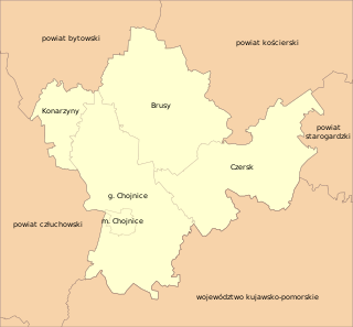
Chojnice County is a unit of territorial administration and local government (powiat) in Pomeranian Voivodeship, northern Poland. It came into being on January 1, 1999, as a result of the Polish local government reforms in 1998. Its administrative seat and largest town is Chojnice, which lies 103 kilometres (64 mi) south-west of the regional capital Gdańsk. The county also contains the towns of Czersk, lying 30 km (19 mi) east of Chojnice, and Brusy, 24 km (15 mi) north-east of Chojnice.

Rypin County is a unit of territorial administration and local government (powiat) in Kuyavian-Pomeranian Voivodeship, north-central Poland. It came into being on January 1, 1999, as a result of the Polish local government reforms passed in 1998. Its administrative seat and only town is Rypin, which lies 56 km (35 mi) east of Toruń and 98 km (61 mi) east of Bydgoszcz.

Lipno County is a unit of territorial administration and local government (powiat) in Kuyavian-Pomeranian Voivodeship, north-central Poland. It was formed on January 1, 1999, as a result of the Polish local government reforms passed in 1998. Its administrative seat and largest town is Lipno, which lies 43 km (27 mi) south-east of Toruń and 84 km (52 mi) east of Bydgoszcz. The county also contains the towns of Skępe, lying 13 km (8 mi) east of Lipno, and Dobrzyń nad Wisłą, 26 km (16 mi) south-east of Lipno.

Nakło County is a unit of territorial administration and local government (powiat) in Kuyavian-Pomeranian Voivodeship, north-central Poland. It came into being on January 1, 1999, as a result of the Polish local government reforms passed in 1998. Its administrative seat and largest town is Nakło nad Notecią, which lies 28 km (17 mi) west of Bydgoszcz and 70 km (43 mi) west of Toruń. The county contains three other towns: Szubin, lying 18 km (11 mi) south-east of Nakło nad Notecią, Kcynia, lying 18 km (11 mi) south-west of Nakło nad Notecią, and Mrocza, 12 km (7 mi) north of Nakło nad Notecią.

Aleksandrów County is a unit of territorial administration and local government (powiat) in Kuyavian-Pomeranian Voivodeship, north-central Poland. It came into being on January 1, 1999, as a result of the Polish local government reforms passed in 1998. Its administrative seat and largest town is Aleksandrów Kujawski, which lies 20 km (12 mi) south of Toruń and 55 km (34 mi) south-east of Bydgoszcz. The county also contains the towns of Ciechocinek, lying 6 km (4 mi) east of Aleksandrów Kujawski, and Nieszawa, 14 km (9 mi) east of Aleksandrów Kujawski.

Brodnica County is a unit of territorial administration and local government (powiat) in Kuyavian-Pomeranian Voivodeship, north-central Poland. It came into being on January 1, 1999, as a result of the Polish local government reforms passed in 1998. Its administrative seat and largest town is Brodnica, which lies 58 km (36 mi) north-east of Toruń and 95 km (59 mi) east of Bydgoszcz. The county also contains the towns of Jabłonowo Pomorskie, lying 23 km (14 mi) north-west of Brodnica, and Górzno, 18 km (11 mi) east of Brodnica.

Żnin County is a unit of territorial administration and local government (powiat) in Kuyavian-Pomeranian Voivodeship, north-central Poland. It came into being on January 1, 1999, as a result of the Polish local government reforms passed in 1998. Its administrative seat and largest town is Żnin, which lies 36 km (22 mi) south-west of Bydgoszcz and 65 km (40 mi) west of Toruń. The county contains three other towns: Barcin, lying 17 km (11 mi) east of Żnin, Łabiszyn, lying 19 km (12 mi) north-east of Żnin, and Janowiec Wielkopolski, 18 km (11 mi) south-west of Żnin.

Mogilno County is a unit of territorial administration and local government (powiat) in Kuyavian-Pomeranian Voivodeship, north-central Poland. It was formed on January 1, 1999, as a result of the Polish local government reforms passed in 1998. Its administrative seat and largest town is Mogilno, which lies 52 km (32 mi) south of Bydgoszcz and 62 km (39 mi) south-west of Toruń. The only other town in the county is Strzelno, lying 16 km (10 mi) east of Mogilno.

Sępólno County is a unit of territorial administration and local government (powiat) in Kuyavian-Pomeranian Voivodeship, north-central Poland. It came into being on January 1, 1999, as a result of the Polish local government reforms passed in 1998. Its administrative seat and largest town is Sępólno Krajeńskie, which lies 49 km (30 mi) north-west of Bydgoszcz and 86 km (53 mi) north-west of Toruń. The county also contains the towns of Więcbork, lying 11 km (7 mi) south of Sępólno Krajeńskie, and Kamień Krajeński, 10 km (6 mi) north of Sępólno Krajeńskie.

Inowrocław County is a unit of territorial administration and local government (powiat) in Kuyavian-Pomeranian Voivodeship, north-central Poland. It came into being on January 1, 1999, as a result of the Polish local government reforms passed in 1998. Its administrative seat and largest town is Inowrocław, which lies 36 km (22 mi) south-west of Toruń and 40 km (25 mi) south-east of Bydgoszcz. The county contains four other towns: Kruszwica, lying 14 km (9 mi) south of Inowrocław, Janikowo, lying 12 km (7 mi) south-west of Inowrocław, Gniewkowo, 16 km (10 mi) north-east of Inowrocław, and Pakość, 13 km (8 mi) west of Inowrocław.

Chełmno County is a unit of territorial administration and local government (powiat) in Kuyavian-Pomeranian Voivodeship, north-central Poland. It came into being on 1 January 1999, as a result of the Polish local government reforms adopted in 1998. Its administrative seat and only town is Chełmno, which lies 40 km (25 mi) north of Toruń and 40 km (25 mi) north-east of Bydgoszcz.

Wąbrzeźno County is a unit of territorial administration and local government (powiat) in Kuyavian-Pomeranian Voivodeship, north-central Poland. It came into being on January 1, 1999, as a result of the Polish local government reforms passed in 1998. Its administrative seat and only town is Wąbrzeźno, which lies 36 km (22 mi) north-east of Toruń and 66 km (41 mi) east of Bydgoszcz.

Radziejów County is a unit of territorial administration and local government (powiat) in Kuyavian-Pomeranian Voivodeship, north-central Poland. It came into being on January 1, 1999, as a result of the Polish local government reforms passed in 1998. Its administrative seat and largest town is Radziejów, which lies 45 km (28 mi) south of Toruń and 64 km (40 mi) south-east of Bydgoszcz. The only other town in the county is Piotrków Kujawski, lying 10 km (6 mi) south of Radziejów.

Świecie County is a unit of territorial administration and local government (powiat) in Kuyavian-Pomeranian Voivodeship, north-central Poland. It came into being on January 1, 1999, as a result of the Polish local government reforms passed in 1998. Its administrative seat and largest town is Świecie, which lies 45 km (28 mi) north of Toruń and 45 km (28 mi) north-east of Bydgoszcz. The only other town in the county is Nowe, lying 33 km (21 mi) north-east of Świecie.

Bydgoszcz County is a unit of territorial administration and local government (powiat) in Kuyavian-Pomeranian Voivodeship, north-central Poland. It was created on 1 January 1999 as a result of the Polish local government reforms passed in 1998. Its administrative seat is the city of Bydgoszcz, although the city is not part of the county. The only towns in Bydgoszcz County are Solec Kujawski, which lies 17 km (11 mi) east of Bydgoszcz, and Koronowo, 23 km (14 mi) north of Bydgoszcz.

Golub-Dobrzyń County is a unit of territorial administration and local government (powiat) in Kuyavian-Pomeranian Voivodeship, north-central Poland. It came into being on January 1, 1999, as a result of the Polish local government reforms passed in 1998. Its administrative seat and largest town is the town of Golub-Dobrzyń, which lies 30 km (19 mi) east of Toruń and 71 km (44 mi) east of Bydgoszcz. The only other town in the county is Kowalewo Pomorskie, lying 13 km (8 mi) north-west of Golub-Dobrzyń.


