The Drut or Druć is a river in Belarus, a right tributary of Dnieper. It originates in the Orsha Upland in the Belarusian Ridge and flows through Vitebsk, Mogilev and Homiel provinces of Belarus.

Piecki is a village in the administrative district of Gmina Nowa Wieś Wielka, within Bydgoszcz County, Kuyavian-Pomeranian Voivodeship, in north-central Poland. It lies 7 kilometres (4 mi) north of Nowa Wieś Wielka and 11 km (7 mi) south-east of Bydgoszcz.
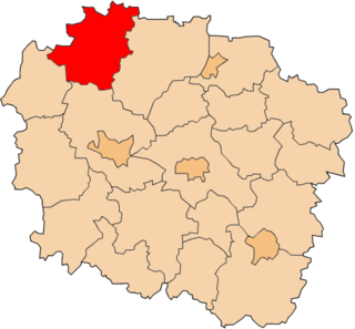
Krzywogoniec is a village in the administrative district of Gmina Cekcyn, within Tuchola County, Kuyavian-Pomeranian Voivodeship, in north-central Poland. A village in Poland founded by Borowiacy Tucholscy .The village has a population of 190.

Miradz is a village in the administrative district of Gmina Strzelno, within Mogilno County, Kuyavian-Pomeranian Voivodeship, in north-central Poland.

Rogoźniczka is a village in the administrative district of Gmina Międzyrzec Podlaski, within Biała Podlaska County, Lublin Voivodeship, in eastern Poland.
Olszanka is a village in the administrative district of Gmina Łopiennik Górny, within Krasnystaw County, Lublin Voivodeship, in eastern Poland.
Szaciły is a village in the administrative district of Gmina Dobrzyniewo Duże, within Białystok County, Podlaskie Voivodeship, in north-eastern Poland. It lies approximately 6 kilometres (4 mi) north of Dobrzyniewo Duże and 18 km (11 mi) north-west of the regional capital Białystok.
Miodusy-Pokrzywne is a village in the administrative district of Gmina Perlejewo, within Siemiatycze County, Podlaskie Voivodeship, in north-eastern Poland.
Korzeniów is a village in the administrative district of Gmina Ułęż, within Ryki County, Lublin Voivodeship, in eastern Poland. It lies approximately 6 kilometres (4 mi) west of Ułęż, 9 km (6 mi) south-east of Ryki, and 53 km (33 mi) north-west of the regional capital Lublin.
Złota is a village in Pińczów County, Świętokrzyskie Voivodeship, in south-central Poland. It is the seat of the gmina called Gmina Złota. It lies approximately 18 kilometres (11 mi) south of Pińczów and 56 km (35 mi) south of the regional capital Kielce.
Józefina is a village in the administrative district of Gmina Żabia Wola, within Grodzisk Mazowiecki County, Masovian Voivodeship, in east-central Poland. It lies approximately 10 kilometres (6 mi) south of Grodzisk Mazowiecki and 32 km (20 mi) south-west of Warsaw.
Borówek is a village in the administrative district of Gmina Latowicz, within Mińsk County, Masovian Voivodeship, in east-central Poland.
Niwa is a village in the administrative district of Gmina Dzierzążnia, within Płońsk County, Masovian Voivodeship, in east-central Poland.
Białe Błoto is a village in the administrative district of Gmina Winnica, within Pułtusk County, Masovian Voivodeship, in east-central Poland.
Iłów is a village in Sochaczew County, Masovian Voivodeship, in east-central Poland. It is the seat of the gmina called Gmina Iłów. It lies approximately 19 kilometres (12 mi) north-west of Sochaczew and 68 km (42 mi) west of Warsaw.
Borki is a village in the administrative district of Gmina Koło, within Koło County, Greater Poland Voivodeship, in west-central Poland.
Folwark is a village in the administrative district of Gmina Rawicz, within Rawicz County, Greater Poland Voivodeship, in west-central Poland.
Janowice is a village in the administrative district of Gmina Lubsko, within Żary County, Lubusz Voivodeship, in western Poland. It lies approximately 7 kilometres (4 mi) north-east of Lubsko, 23 km (14 mi) north of Żary, and 35 km (22 mi) west of Zielona Góra.
Redwanki is a village in the administrative district of Gmina Ustka, within Słupsk County, Pomeranian Voivodeship, in northern Poland. It lies approximately 10 kilometres (6 mi) east of Ustka, 15 km (9 mi) north of Słupsk, and 109 km (68 mi) west of the regional capital Gdańsk.
Bertyny is a village in the administrative district of Gmina Reszel, within Kętrzyn County, Warmian-Masurian Voivodeship, in northern Poland.