Bacharach

Last updated • 9 min readFrom Wikipedia, The Free Encyclopedia
Bacharach
Bacharach from the Postenturm.jpg
Bacharach from the Postenturm.
Wappen von Bacharach.png
Location of Bacharach within Mainz-Bingen district
Bacharach in MZ.svgBreitscheidSankt JohannWolfsheimBubenheimMommenheimDalheimFriesenheimHillesheim
Germany adm location map.svg
Red pog.svg
Bacharach
Rhineland-Palatinate location map.svg
Red pog.svg
Bacharach
Coordinates: 50°04′N07°46′E / 50.067°N 7.767°E / 50.067; 7.767
Country Germany
State Rhineland-Palatinate
District Mainz-Bingen
Municipal assoc. Rhein-Nahe
Area
  Total23.65 km2 (9.13 sq mi)
Elevation
70 m (230 ft)
Population
 (2022-12-31) [1]
  Total1,837
  Density78/km2 (200/sq mi)
Time zone UTC+01:00 (CET)
  Summer (DST) UTC+02:00 (CEST)
Postal codes
55422
Dialling codes 06743
Vehicle registration MZ
Website www.bacharach.de
Aerial photograph 2007 Bacharach Luftbild 092.jpg
Aerial photograph 2007
Rhine in Bacharach, view from Castle Stahleck Bacharach town river.jpg
Rhine in Bacharach, view from Castle Stahleck

Bacharach ( pronunciation , also known as Bacharach am Rhein) is a town in the Mainz-Bingen district in Rhineland-Palatinate, Germany. It belongs to the Verbandsgemeinde of Rhein-Nahe, whose seat is in Bingen am Rhein, although that town is not within its bounds.

Contents

The original name Baccaracus suggests a Celtic origin. Above the town stands Stahleck Castle (Burg Stahleck), now a youth hostel.

Geography

Location

The town lies in the Rhine Gorge, 48 km south of Koblenz.

Constituent communities

Bacharach is divided into several Ortsteile . The outlying centre of Steeg lies in the Steeg Valley (Steeger Tal) off to the side, away from the Rhine. This glen lies between Medenscheid and Neurath to the south and Henschhausen to the north on the heights.

History

In the early 11th century, Bacharach had its first documentary mention. [2] It may have been that as early as the 7th century, the kingly domain passed into Archbishop of Cologne Kunibert’s ownership; pointing to this is a Kunibertskapelle (chapel) on the spot where now stands the Wernerkapelle. The Vögte of the Cologne estate were the Elector of the Palatinate, who over time pushed back Cologne’s influence. Count Palatine already had so much influence that he resided at Stahleck Castle. His successor Konrad von Staufen’s daughter secretly wed at Stahleck Castle a son of the Welfs, who were family foes, leading to Bacharach’s, and indeed the whole County Palatine’s, falling for a short time to Henry of Brunswick. In 1214 the Wittelsbachs became Bacharach’s new lords. Together with the Unteramt of Kaub they received here their most important toll and revenue source. In 1314 it was decided to choose Louis the Bavarian as the German king. Furthermore, Bacharach was the most important transfer point for the wine trade, as barrels were offloaded here from the smaller ships that were needed to get by the Binger Loch (a quartzite reef in the Rhine upstream near Bingen) and loaded onto bigger ones. From then on, the wine bore the designation Bacharacher. The timber trade from the Hunsrück also brought Bacharach importance, and in 1356, Bacharach was granted town rights.

Wernerkapelle in an engraving by William Tombleson Tombleson Bacharach Werner.jpg
Wernerkapelle in an engraving by William Tombleson

Widely visible is the Wernerkapelle, a Rheinromantik landmark of the town, lying on the way up to Stahleck Castle from the town. It is the expanded Kunibertkapelle, and is still an unfinished Gothic ruin today. Its namesake is Werner of Oberwesel, known in connection with pogroms triggered by his death. According to the Christian blood libel, which was typical of the times, a 16-year-old Werner was murdered on Maundy Thursday 1287 by members of the local Jewish community, who then used his blood for Passover observances. On the grounds of this alleged ritual murder, there arose an anti-Semitic mob who waged a pogrom, wiping out Jewish communities in the Middle and Lower Rhine and Moselle regions. In folk Christianity arose the cult of Werner, which was only stricken from the Bishopric of Trier calendar in 1963.

In 1344, building work began on the town wall, and was already finished about 1400. In 1545, the town, along with the Palatinate, became Protestant under Count Palatine Friedrich II. Stahleck Castle and the town wall could not stop Bacharach from undergoing eight changes in military occupation in the Thirty Years' War, nor the war’s attendant sackings. Moreover, further destruction was wrought by several town fires. Then, in 1689, French troops fighting in the Nine Years' War blew Stahleck Castle and four of the town wall’s towers up.

Bacharach about 1832 in an engraving by William Tombleson Tombleson Bacharach.jpg
Bacharach about 1832 in an engraving by William Tombleson

In 1794, French Revolutionary troops occupied the Rhine’s left bank and in 1802, Bacharach became temporarily French. During the War of the Sixth Coalition the Prussian Field Marshal Blücher, after crossing the Rhine near Kaub, came through Bacharach and the Steeg Valley on New Year’s Night 1813-1814 with his troops on the way to France. Recalling this event is a monument stone somewhat downstream, across from Kaub. After the Congress of Vienna, the town went, along with the Rhine’s left bank, up to and including Bingerbrück, to Prussia. After the harbour silted up, Bacharach fell into a slumber from which it only awoke in the course of the Rheinromantik. Among the first of the prominent visitors at this time was the French writer Victor Hugo.

Illustration by Max Liebermann for Heinrich Heine's historical novel Der Rabbi von Bacherach (The Rabbi of Bacherach) Max Liebermann Illustration Der Rabbi von Bacherach.jpg
Illustration by Max Liebermann for Heinrich Heine's historical novel Der Rabbi von Bacherach (The Rabbi of Bacherach)

Caring for and maintaining Bacharach’s building monuments, spurred on in the early 20th century by the Rhenish Association for Monument Care and Landscape Preservation (Rheinischer Verein für Denkmalpflege und Landschaftsschutz) which took on the then highly endangered town wall and Stahleck Castle ruin jobs, and the great dedication of the state of Rhineland-Palatinate to the Wernerkapelle have seen to it that Bacharach is still a jewel of the Rheinromantik and a multifaceted documentary site of mediaeval architecture on the Middle Rhine. The Wernerkapelle ruin is under monumental protection and before it a plaque has been placed recalling the inhuman crimes against Jewish residents and also containing a quotation from a prayer by Pope John XXIII for a change in Christians’ thinking in their relationship with the Jews:

“We recognize today that many centuries of blindness have shrouded our eyes, so that we no longer saw the goodliness of Thy Chosen People and no longer recognized our firstborn brother’s traits. We discover now that a mark of Cain stands on our forehead. In the course of the centuries our brother Abel has lain in blood that we spilt, and he has wept tears that we brought forth, because we forgot Thy love. Forgive us the curse that we unrightfully affixed to the Jews’ name. Forgive us for nailing Thee in their flesh for a second time to the Cross. For we knew not what we did........."

Today Bacharach thrives on tourism and wine from Bacharach is still enjoying international popularity. Not to be overlooked, however, are problems arising from a shrinking population, itself brought about by a lack of prospects.

Amalgamations

On 7 June 1969, the formerly self-administering municipality of Steeg was amalgamated with Bacharach.

Town partnerships

Coat of arms

The town’s arms might be described thus: Per fess at the nombril point sable a lion rampant Or armed, langued and crowned gules, and bendy lozengy argent and azure.

Population development

The number 1871-1987 are census results [3]

YearInhabitants
18151.794
18352.342
18712.511
19052.859
19392.746
19503.091
YearInhabitants
19612.853
19702.712
19872.184
19972.268
20052.097
20161,901

Economy and infrastructure

Transport

Bacharach lies on the Rhine’s left bank and can be reached by Bundesstraße 9 or the Rhine. Running regularly to and from Bacharach are the excursion ships of the Köln-Düsseldorfer-Rheinschiffahrt, or KD for short.

Transport routes on the other side of the river can be reached by ferry from the Engelsburg (castle) over to Kaub.

The town belongs to the Rhein-Nahe-Nahverkehrsverbund – a local transport association. Bacharach lies on the West Rhine Railway and is served by Cologne - KoblenzBoppardBacharachBingen am RheinMainz Regionalbahn trains (as of August 2022).

Culture and sightseeing

Saint Peter's Bacharach2.jpg
Saint Peter’s
Wernerkapelle Bacharach3.jpg
Wernerkapelle
Blucher monument stone Blucher Gedenkstein.JPG
Blücher monument stone

Bacharach in art

Regular events

Impression of the Vierthalermarkt 2007 Vierthalermarkt.jpg
Impression of the Vierthälermarkt 2007

Notable people

Gerhard von Kugelgen GerhardVonKugelgen.jpg
Gerhard von Kügelgen

Further reading

Documents

Related Research Articles

<span class="mw-page-title-main">Stahleck Castle</span> 12th-century fortified castle in Bacharach, Germany

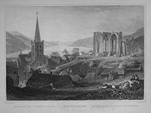
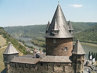
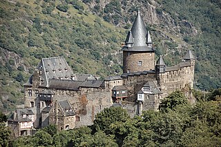
Stahleck Castle is a 12th-century fortified castle in the Upper Middle Rhine Valley at Bacharach in Rhineland-Palatinate, Germany. It stands on a crag approximately 160 metres (520 ft) above sea level on the left bank of the river at the mouth of the Steeg valley, approximately 50 kilometres (31 mi) south of Koblenz, and offers a commanding view of the Lorelei valley. Its name means "impregnable castle on a crag", from the Middle High German words stahel (steel) and ecke. It has a water-filled partial moat, a rarity in Germany. Built on the orders of the Archbishop of Cologne, it was destroyed in the late 17th century but rebuilt in the 20th and is now a hostel.

<span class="mw-page-title-main">Rhine Gorge</span> UNESCO World Heritage Site in Rheinland Pfalz and Hessen in Germany

The Rhine Gorge is a popular name for the Upper Middle Rhine Valley, a 65 km section of the Rhine between Koblenz and Rüdesheim in the states of Rhineland-Palatinate and Hesse in Germany. It was added to the UNESCO list of World Heritage Sites in June 2002 because of its beauty as a cultural landscape, its importance as a route of transport across Europe, and the unique adaptations of the buildings and terraces to the steep slopes of the gorge.

<span class="mw-page-title-main">Sankt Goar</span> Town in Rhineland-Palatinate, Germany

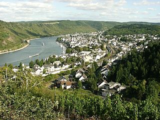
Sankt Goar is a town on the west bank of the Middle Rhine in the Rhein-Hunsrück-Kreis (district) in Rhineland-Palatinate, Germany. It belongs to the Verbandsgemeinde Hunsrück-Mittelrhein, whose seat is in Emmelshausen.

<span class="mw-page-title-main">Rüdesheim am Rhein</span> Town in Hesse, Germany

Rüdesheim am Rhein is a German winemaking town in the Rhine Gorge, and part of the UNESCO World Heritage Site in this region. It lies in the Rheingau-Taunus-Kreis district in the Regierungsbezirk of Darmstadt, Hessen. Known as Rüdesheim, it is officially Rüdesheim am Rhein, to distinguish it from Rüdesheim an der Nahe. It is a major tourist attraction, especially for foreign visitors.

<span class="mw-page-title-main">Boppard</span> Town in Rhineland-Palatinate, Germany

Boppard, formerly also spelled Boppart, is a town and municipality in the Rhein-Hunsrück-Kreis (district) in Rhineland-Palatinate, Germany, lying in the Rhine Gorge, a UNESCO World Heritage Site. The town is also a state-recognized tourism resort (Fremdenverkehrsort) and is a winegrowing centre.

<span class="mw-page-title-main">Middle Rhine</span> Section of the river Rhine in Germany

Middle Rhine is the section of the Rhine between Bingen and Bonn in Germany. It flows through the Rhine Gorge, a formation created by erosion, which happened at about the same rate as an uplift in the region, leaving the river at about its original level, and the surrounding lands raised. This gorge is quite deep, about 130 metres (430 ft) from the top of the rocks down to the average water-line.

<span class="mw-page-title-main">Kaub</span> Town in Rhineland-Palatinate, Germany

Kaub is a town in Germany, state Rhineland-Palatinate, district Rhein-Lahn-Kreis. It is part of the municipality (Verbandsgemeinde) Loreley. It is located on the right bank of the Rhine, approx. 50 km west from Wiesbaden. It is connected to Wiesbaden and Koblenz by railway. It has a Roman Catholic and an Evangelical church, and a statue of General Blücher. Historically, trade mainly consisted of the wines of the district.

<span class="mw-page-title-main">Rheinböllen</span> Town in Rhineland-Palatinate, Germany

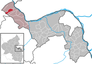
Rheinböllen is a town in the Rhein-Hunsrück-Kreis (district) in Rhineland-Palatinate, Germany. It belongs to the Verbandsgemeinde Simmern-Rheinböllen, whose seat is in Simmern. It was the seat of the former Verbandsgemeinde Rheinböllen.

<span class="mw-page-title-main">Oberwesel</span> Town in Rhineland-Palatinate, Germany

Oberwesel is a town on the Middle Rhine in the Rhein-Hunsrück-Kreis (district) in Rhineland-Palatinate, Germany. It belongs to the Verbandsgemeinde Hunsrück-Mittelrhein, whose seat is in Emmelshausen.

<span class="mw-page-title-main">Pfalzgrafenstein Castle</span> Toll castle in the River Rhine near Kaub, Germany

Pfalzgrafenstein Castle is a toll castle located on Falkenau island in the Rhine River, near the bank close to Kaub, Germany. Also known as "the Pfalz", Pfalzgrafenstein Castle has never been destroyed since being established in 1326/27.

<span class="mw-page-title-main">Manubach</span> Municipality in Rhineland-Palatinate, Germany

Manubach is an Ortsgemeinde – a municipality belonging to a Verbandsgemeinde, a kind of collective municipality – in the Mainz-Bingen district in Rhineland-Palatinate, Germany.

<span class="mw-page-title-main">Oberdiebach</span> Municipality in Rhineland-Palatinate, Germany

Oberdiebach is an Ortsgemeinde – a municipality belonging to a Verbandsgemeinde, a kind of collective municipality – in the Mainz-Bingen district in Rhineland-Palatinate, Germany.

<span class="mw-page-title-main">Trechtingshausen</span> Municipality in Rhineland-Palatinate, Germany

Trechtingshausen is an Ortsgemeinde – a municipality belonging to a Verbandsgemeinde, a kind of collective municipality – in the Mainz-Bingen district in Rhineland-Palatinate, Germany.

<span class="mw-page-title-main">Schnorbach</span> Municipality in Rhineland-Palatinate, Germany

Schnorbach is an Ortsgemeinde – a municipality belonging to a Verbandsgemeinde, a kind of collective municipality – in the Rhein-Hunsrück-Kreis (district) in Rhineland-Palatinate, Germany. It belongs to the Verbandsgemeinde Simmern-Rheinböllen, whose seat is in Simmern.

<span class="mw-page-title-main">Rheinburgenweg Trail</span>

Rhine Castle trail - Rheinburgenweg, follows the left side of the Rhine from Bingen to Remagen-Rolandseck and the right side takes the route of the Rheinsteig from Rüdesheim am Rhein to Koblenz.

<span class="mw-page-title-main">Werner of Oberwesel</span>

Werner of Oberwesel was a 16-year-old boy whose unexplained death was blamed on Jews, leading to revenge killings of Jews across Europe. He was venerated as a Christian saint, and his memorial day was 19 April.

<span class="mw-page-title-main">Klopp Castle</span> Castle in Bingen am Rhein, Germany

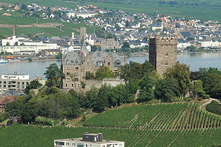
Klopp Castle is a castle in the town of Bingen am Rhein in the Upper Middle Rhine Valley in Rhineland-Palatinate, Germany. In the nineteenth century, the bergfried from the original medieval fortified castle was restored and a new building added which houses the town's administration.

<span class="mw-page-title-main">Rhine romanticism</span>

The Rhine romanticism was the interpretation of the landscape conditions and history of the Rhine Valley in the cultural-historical period of the romanticism, by the end of the 18th century until the late 19th century and was continued in all forms of art expression.

<span class="mw-page-title-main">Toll castle</span> Medieval castle which guarded and controlled a customs post

A toll castle is a castle that, in the Middle Ages and the Early Modern Era, guarded a customs post and was intended to control it. They were typically found in the Holy Roman Empire. Toll castles always stood in the vicinity of an important long-distance trade route over, for example, the Alpine passes or the Middle Rhine. Such castles were usually placed at strategic locations, such as border crossings, river crossings or mountain passes, and were manned by armed guards. The actual toll-collecting point lay below at the road or river and was often linked by walls to the castle itself.

References

  1. "Bevölkerungsstand 2022, Kreise, Gemeinden, Verbandsgemeinden" (PDF) (in German). Statistisches Landesamt Rheinland-Pfalz. 2023.
  2. Urkunde Nr. 658. In: Friedrich Wilhelm Oediger (Bearb.): Die Regesten der Erzbischöfe von Köln im Mittelalter. Band 1: 313–1099. Hanstein, Bonn 1954–61.
  3. "Statistisches Landesamt Rheinland-Pfalz | template". Archived from the original on 2016-12-02. Retrieved 2016-12-02.