Weiler bei Bingen

Last updated
Weiler bei Bingen
DEU Weiler bei Bingen COA.png
Coat of arms
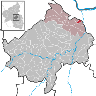
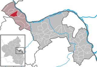
Location of Weiler bei Bingen within Mainz-Bingen district
Weiler bei Bingen in MZ.svg
Germany adm location map.svg
Red pog.svg
Weiler bei Bingen
Rhineland-Palatinate location map.svg
Red pog.svg
Weiler bei Bingen
Coordinates: 49°57′28″N07°52′01″E / 49.95778°N 7.86694°E / 49.95778; 7.86694 Coordinates: 49°57′28″N07°52′01″E / 49.95778°N 7.86694°E / 49.95778; 7.86694
Country Germany
State Rhineland-Palatinate
District Mainz-Bingen
Municipal assoc. Rhein-Nahe
Government
   Mayor Erwin Owtscharenko (CDU)
Area
[1]
  Total22.79 km2 (8.80 sq mi)
Elevation
250 m (820 ft)
Population
(2017-12-31) [2]
  Total2,552
  Density110/km2 (290/sq mi)
Time zone CET/CEST (UTC+1/+2)
Postal codes
55413
Dialling codes 06721
Vehicle registration MZ
Website www.weiler-bei-bingen.de
Panorama of Weiler bei Bingen Panorama von Weiler bei Bingen.jpg
Panorama of Weiler bei Bingen

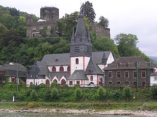
Weiler bei Bingen is an Ortsgemeinde – a municipality belonging to a Verbandsgemeinde , a kind of collective municipality – in the Mainz-Bingen district in Rhineland-Palatinate, Germany. The winegrowing centre belongs to the Verbandsgemeinde of Rhein-Nahe, whose seat is in Bingen am Rhein, although that town is not within its bounds.

Municipalities of Germany the lowest official level of territorial division in Germany

Municipalities are the lowest level of official territorial division in Germany. This is most commonly the third level of territorial division, ranking after the Land (state) and Kreis (district). The Gemeinde which is one level lower in those states also includes Regierungsbezirke as an intermediate territorial division. The Gemeinde is one level higher if it is not part of a Samtgemeinde. Only 10 municipalities in Germany have fifth level administrative subdivisions and all of them are in Bavaria. The highest degree of autonomy may be found in the Gemeinden which are not part of a Kreis. These Gemeinden are referred to as Kreisfreie Städte or Stadtkreise, sometimes translated as having "city status". This can be the case even for small municipalities. However, many smaller municipalities have lost this city status in various administrative reforms in the last 40 years when they were incorporated into a Kreis. In some states they retained a higher measure of autonomy than the other municipalities of the Kreis. Municipalities titled Stadt are urban municipalities while those titled Gemeinde are classified as rural municipalities.

A Verbandsgemeinde is a low-level administrative unit in the German federal states of Rhineland-Palatinate and Saxony-Anhalt. A Verbandsgemeinde is typically composed of a small group of villages or towns.

Mainz-Bingen is a district (Kreis) in the east of Rhineland-Palatinate, Germany. Neighboring districts are Rheingau-Taunus, the district-free cities Wiesbaden and Mainz, the districts Groß-Gerau, Alzey-Worms, Bad Kreuznach, and Rhein-Hunsrück.

Contents

Geography

Location

Weiler bei Bingen lies between Koblenz and Bad Kreuznach southeast of Bingen Forest (Binger Wald) and borders in the east on Bingen. Indeed, its name is German for “Hamlet near Bingen”.

Koblenz Place in Rhineland-Palatinate, Germany

Koblenz, spelled Coblenz before 1926, is a German city situated on both banks of the Rhine where it is joined by the Moselle.

Bad Kreuznach Place in Rhineland-Palatinate, Germany

Bad Kreuznach is a town in the Bad Kreuznach district in Rhineland-Palatinate, Germany. It is a spa town most well known for its medieval bridge dating from around 1300, the Alte Nahebrücke, which is one of the few remaining bridges in the world with buildings on it.

Bingen Forest mountain range

The Bingen Forest is part of the Hunsrück, a low mountain range in the Central Uplands of Germany. It is up to 638.6 m above sea level (NN) and is located in the state of Rhineland-Palatinate.

History

In 823, Weiler bei Bingen had its first documentary mention in one of Louis the Pious’s documents. However, the late Weiler citizen Heinrich Bell's collecting and researching mind is to be thanked for the knowledge that there has been human life in what is now the Weiler municipal area since the earliest times. On an ancient trail, already used by the Celts, the Romans (52 BC to AD 405) built a modern army and trade road linking Mainz with Trier and running right by Weiler (the Via Ausonia). In the part of Bingen Forest lying within Weiler's limits, the remnants of a Roman villa rustica have been being unearthed since 1994.

Louis the Pious King of Aquitaine

Louis the Pious, also called the Fair, and the Debonaire, was the King of the Franks and co-emperor with his father, Charlemagne, from 813. He was also King of Aquitaine from 781.

Celts Ethnolinguistic group

The Celts are an Indo-European ethnolinguistic group of Europe identified by their use of Celtic languages and cultural similarities. The history of pre-Celtic Europe and the exact relationship between ethnic, linguistic and cultural factors in the Celtic world remains uncertain and controversial. The exact geographic spread of the ancient Celts is disputed; in particular, the ways in which the Iron Age inhabitants of Great Britain and Ireland should be regarded as Celts have become a subject of controversy. According to one theory, the common root of the Celtic languages, the Proto-Celtic language, arose in the Late Bronze Age Urnfield culture of Central Europe, which flourished from around 1200 BC.

Ancient Rome History of Rome from the 8th-century BC to the 5th-century

In historiography, ancient Rome is Roman civilization from the founding of the Italian city of Rome in the 8th century BC to the collapse of the Western Roman Empire in the 5th century AD, encompassing the Roman Kingdom, Roman Republic and Roman Empire until the fall of the western empire. The civilization began as an Italic settlement in the Italian Peninsula, conventionally founded in 753 BC, that grew into the city of Rome and which subsequently gave its name to the empire over which it ruled and to the widespread civilisation the empire developed. The Roman Empire expanded to become one of the largest empires in the ancient world, though still ruled from the city, with an estimated 50 to 90 million inhabitants and covering 5.0 million square kilometres at its height in AD 117.

Weiler was always very tightly bound with Bingen even from the earliest times. The Weiler municipal area was part of the Binger Mark. The Bishops and Archbishops of Mainz held the lordship over both centres. Weiler passed to the Mainz Cathedral Chapter in 1438 and remained in its hands until French Revolutionary troops occupied the Rhine’s left bank in 1792 to 1794. The Treaty of Campo Formio ended this arrangement when in 1797 the river Nahe became the boundary between the French departments of Mont-Tonnerre (Donnersberg) and Rhin-et-Moselle (Rhein-Mosel). The Congress of Vienna eventually assigned Weiler to the Kingdom of Prussia and in 1816, Bingen passed to the Grand Duchy of Hesse-Darmstadt. Now the Nahe had become an international border. With the building of the railway lines on the Rhine and Nahe, Weiler’s outlying centre of Rupertsberg earned greater importance. In 1892, through a decree from the Kingdom of Prussia, it became self-administering under the name Bingerbrück and was split off from Weiler’s municipal area. In 1969, it was amalgamated with the town of Bingen.

French Revolution social and political revolution in France and its colonies occurring from 1789 to 1798

The French Revolution was a period of far-reaching social and political upheaval in France and its colonies beginning in 1789. The Revolution overthrew the monarchy, established a republic, catalyzed violent periods of political turmoil, and finally culminated in a dictatorship under Napoleon who brought many of its principles to areas he conquered in Western Europe and beyond. Inspired by liberal and radical ideas, the Revolution profoundly altered the course of modern history, triggering the global decline of absolute monarchies while replacing them with republics and liberal democracies. Through the Revolutionary Wars, it unleashed a wave of global conflicts that extended from the Caribbean to the Middle East. Historians widely regard the Revolution as one of the most important events in human history.

Rhine river in Western Europe

The Rhine is one of the major European rivers, which has its sources in Switzerland and flows in an mostly northerly direction through Germany and The Netherlands, emptying into the North Sea. The river begins in the Swiss canton of Graubünden in the southeastern Swiss Alps, forms part of the Swiss-Liechtenstein, Swiss-Austrian, Swiss-German and then the Franco-German border, then flows through the German Rhineland and the Netherlands and eventually empties into the North Sea.

Treaty of Campo Formio 1797 treaty between Napoleonic France and Habsburg Austria

The Treaty of Campo Formio was signed on 18 October 1797 by Napoleon Bonaparte and Count Philipp von Cobenzl as representatives of the French Republic and the Austrian monarchy, respectively. The treaty followed the armistice of Leoben, which had been forced on the Habsburgs by Napoleon's victorious campaign in Italy. It ended the War of the First Coalition and left Great Britain fighting alone against revolutionary France.

Weiler’s history, however, cannot be split away from its Catholic church’s history. On the spot where once stood the little old church, which was being mentioned in documents as early as 1128, the new hall church, built in Gothic Revival style, was consecrated in 1866. It still dominates Weiler bei Bingen’s skyline today.

Gothic Revival architecture Architectural movement

Gothic Revival is an architectural movement popular in the Western world that began in the late 1740s in England. Its popularity grew rapidly in the early 19th century, when increasingly serious and learned admirers of neo-Gothic styles sought to revive medieval Gothic architecture, in contrast to the neoclassical styles prevalent at the time. Gothic Revival draws features from the original Gothic style, including decorative patterns, finials, lancet windows, hood moulds and label stops.

On 1 January 1973, the municipality’s name was changed from the former Weiler bei Bingerbrück to Weiler bei Bingen.

Politics

Municipal council

The council is made up of 21 council members, counting the part-time mayor, with seats apportioned thus: [3]

SPD CDU FDP FWG Total
2009691420 seats
2004591520 seats

(as at municipal election held on 13 June 2004)

Coat of arms

The municipality's arms might be described thus: Per fess gules and argent, a wheel spoked of six counterchanged.

Economy and infrastructure

Transport

The Autobahn A 61 can be reached through the Stromberg interchange about 7 km away, while the Autobahn A 60 can be reached over Bundesstraße 9 in Bingerbrück (going towards Mainz) after about 9 km.

Education

Related Research Articles

Bingen am Rhein Place in Rhineland-Palatinate, Germany

Bingen am Rhein is a town in the Mainz-Bingen district in Rhineland-Palatinate, Germany.

Waldalgesheim Place in Rhineland-Palatinate, Germany

Waldalgesheim is an Ortsgemeinde – a municipality belonging to a Verbandsgemeinde, a kind of collective municipality – in the Mainz-Bingen district in Rhineland-Palatinate, Germany. It is best known as the site of the Iron Age Waldalgesheim chariot burial.

Rhein-Nahe Verbandsgemeinde in Rhineland-Palatinate

Rhein-Nahe is a Verbandsgemeinde in the district Mainz-Bingen, in Rhineland-Palatinate, Germany. It is situated along the left bank of the Rhine, north of Bingen. Bingen is the seat of the municipality, but not part of it.

Bingen (Rhein) Hauptbahnhof

Bingen (Rhein) Hauptbahnhof is a railway station in the German city of Bingen am Rhein on the West Rhine Railway. It is located in the borough of Bingerbrück. The station that serves central Bingen is called Bingen Stadt.

Dorsheim Place in Rhineland-Palatinate, Germany

Dorsheim is an Ortsgemeinde – a municipality belonging to a Verbandsgemeinde, a kind of collective municipality – in the Bad Kreuznach district in Rhineland-Palatinate, Germany. It belongs to the Verbandsgemeinde of Langenlonsheim, whose seat is in the like-named municipality. Dorsheim is a winegrowing centre.

Langenthal, Rhineland-Palatinate Place in Rhineland-Palatinate, Germany

Langenthal is an Ortsgemeinde – a municipality belonging to a Verbandsgemeinde, a kind of collective municipality – in the Bad Kreuznach district in Rhineland-Palatinate, Germany. It belongs to the Verbandsgemeinde of Bad Sobernheim, whose seat is in the like-named town.

Rümmelsheim Place in Rhineland-Palatinate, Germany

Rümmelsheim is an Ortsgemeinde – a municipality belonging to a Verbandsgemeinde, a kind of collective municipality – in the Bad Kreuznach district in Rhineland-Palatinate, Germany. It belongs to the Verbandsgemeinde of Langenlonsheim, whose seat is in the like-named municipality. Rümmelsheim is a winegrowing village.

Kronweiler Place in Rhineland-Palatinate, Germany

Kronweiler is an Ortsgemeinde – a municipality belonging to a Verbandsgemeinde, a kind of collective municipality – in the Birkenfeld district in Rhineland-Palatinate, Germany. It belongs to the Verbandsgemeinde of Birkenfeld, whose seat is in the like-named town.

Rötsweiler-Nockenthal Place in Rhineland-Palatinate, Germany

Rötsweiler-Nockenthal is an Ortsgemeinde – a municipality belonging to a Verbandsgemeinde, a kind of collective municipality – in the Birkenfeld district in Rhineland-Palatinate, Germany. It belongs to the Verbandsgemeinde of Birkenfeld, whose seat is in the like-named town.

Breitscheid, Mainz-Bingen Place in Rhineland-Palatinate, Germany

Breitscheid is an Ortsgemeinde – a municipality belonging to a Verbandsgemeinde, a kind of collective municipality – in the Mainz-Bingen district in Rhineland-Palatinate, Germany.

Manubach Place in Rhineland-Palatinate, Germany

Manubach is an Ortsgemeinde – a municipality belonging to a Verbandsgemeinde, a kind of collective municipality – in the Mainz-Bingen district in Rhineland-Palatinate, Germany.

Mommenheim, Germany Place in Rhineland-Palatinate, Germany

Mommenheim is an Ortsgemeinde – a municipality belonging to a Verbandsgemeinde, a kind of collective municipality – in the Mainz-Bingen district in Rhineland-Palatinate, Germany.

Welgesheim Place in Rhineland-Palatinate, Germany

Welgesheim is an Ortsgemeinde – a municipality belonging to a Verbandsgemeinde, a kind of collective municipality – in the Mainz-Bingen district in Rhineland-Palatinate, Germany.

Münster-Sarmsheim Place in Rhineland-Palatinate, Germany

Münster-Sarmsheim is an Ortsgemeinde – a municipality belonging to a Verbandsgemeinde, a kind of collective municipality – in the Mainz-Bingen district in Rhineland-Palatinate, Germany.

Niederheimbach Place in Rhineland-Palatinate, Germany

Niederheimbach is an Ortsgemeinde – a municipality belonging to a Verbandsgemeinde, a kind of collective municipality – in the Mainz-Bingen district in Rhineland-Palatinate, Germany.

Oberdiebach Place in Rhineland-Palatinate, Germany

Oberdiebach is an Ortsgemeinde – a municipality belonging to a Verbandsgemeinde, a kind of collective municipality – in the Mainz-Bingen district in Rhineland-Palatinate, Germany.

Trechtingshausen Place in Rhineland-Palatinate, Germany

Trechtingshausen is an Ortsgemeinde – a municipality belonging to a Verbandsgemeinde, a kind of collective municipality – in the Mainz-Bingen district in Rhineland-Palatinate, Germany.

Oberheimbach Place in Rhineland-Palatinate, Germany

Oberheimbach is an Ortsgemeinde – a municipality belonging to a Verbandsgemeinde, a kind of collective municipality – in the Mainz-Bingen district in Rhineland-Palatinate, Germany.

Ockenheim Place in Rhineland-Palatinate, Germany

Ockenheim is an Ortsgemeinde – a municipality belonging to a Verbandsgemeinde, a kind of collective municipality – in the Mainz-Bingen district in Rhineland-Palatinate, Germany.

Erbach, Rhineland-Palatinate Place in Rhineland-Palatinate, Germany

Erbach is an Ortsgemeinde – a municipality belonging to a Verbandsgemeinde, a kind of collective municipality – in the Rhein-Hunsrück-Kreis (district) in Rhineland-Palatinate, Germany. It belongs to the Verbandsgemeinde of Rheinböllen, whose seat is in the town of the same name.

References

  1. "Alle politisch selbständigen Gemeinden mit ausgewählten Merkmalen am 31.12.2018 (4. Quartal)". DESTATIS. Archived from the original on 10 March 2019. Retrieved 10 March 2019.
  2. "Bevölkerungsstand 2017 - Gemeindeebene". Statistisches Landesamt Rheinland-Pfalz (in German). 2018.
  3. Kommunalwahl Rheinland-Pfalz 2009, Gemeinderat