
The Canadian Shield, also called the Laurentian Shield or the Laurentian Plateau, is a geologic shield, a large area of exposed Precambrian igneous and high-grade metamorphic rocks. It forms the North American Craton, the ancient geologic core of the North American continent. Glaciation has left the area with only a thin layer of soil, through which exposures of igneous bedrock resulting from its long volcanic history are frequently visible. As a deep, common, joined bedrock region in eastern and central Canada, the shield stretches north from the Great Lakes to the Arctic Ocean, covering over half of Canada and most of Greenland; it also extends south into the northern reaches of the continental United States.

Milk River is a tributary of the Missouri River, 729 miles (1,173 km) long, in the U.S. state of Montana and the Canadian province of Alberta. Rising in the Rocky Mountains, the river drains a sparsely populated, semi-arid watershed of 23,800 square miles (62,000 km2), ending just east of Fort Peck, Montana.

At all geography and geology, a cliff or rock face is an area of rock which has a general angle defined by the vertical, or nearly vertical. Cliffs are formed by the processes of weathering and erosion, with the effect of gravity. Cliffs are common on coasts, in mountainous areas, escarpments and along rivers. Cliffs are usually composed of rock that is resistant to weathering and erosion. The sedimentary rocks that are most likely to form cliffs include sandstone, limestone, chalk, and dolomite. Igneous rocks such as granite and basalt also often form cliffs.

Badlands are a type of dry terrain where softer sedimentary rocks and clay-rich soils have been extensively eroded. They are characterized by steep slopes, minimal vegetation, lack of a substantial regolith, and high drainage density. Ravines, gullies, buttes, hoodoos and other such geologic forms are common in badlands.

Medicine Hat is a city in southeast Alberta, Canada. It is located along the South Saskatchewan River. It is approximately 169 km (105 mi) east of Lethbridge and 295 km (183 mi) southeast of Calgary. This city and the adjacent Town of Redcliff to the northwest are within Cypress County. Medicine Hat was the eighth-largest city in Alberta in 2021 with a population of 63,271. It is also the sunniest place in Canada according to Environment and Climate Change Canada, averaging 2,544 hours of sunshine a year.

The Cypress Hills are a geographical region of hills in southwestern Saskatchewan and southeastern Alberta, Canada. The hills are part of the Missouri Coteau upland. The hills cover an area of approximately 2,500 km2 (970 sq mi). About 400 km2 (150 sq mi) or 16% of this area is an interprovincial park.

A hoodoo is a tall, thin spire of rock formed by erosion. Hoodoos typically consist of relatively soft rock topped by harder, less easily eroded stone that protects each column from the elements. They generally form within sedimentary rock and volcanic rock formations.

Grasslands National Park is a Canadian national park located near the village of Val Marie, Saskatchewan, and one of 44 national parks and park reserves in Canada's national park system. This national park is north of the U.S. state of Montana and lies adjacent to the international boundary. It consists of two separate parcels, the East Block and West Block.

The geology of the Grand Teton area consists of some of the oldest rocks and one of the youngest mountain ranges in North America. The Teton Range, partly located in Grand Teton National Park, started to grow some 9 million years ago. An older feature, Jackson Hole, is a basin that sits aside the range.
Indian Head can refer to:
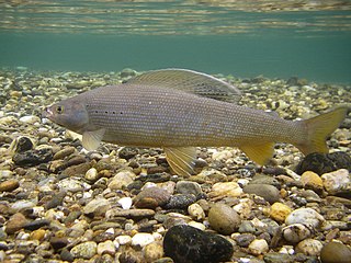
The Arctic grayling is a species of freshwater fish in the salmon family Salmonidae. T. arcticus is widespread throughout the Arctic and Pacific drainages in Canada, Alaska, and Siberia, as well as the upper Missouri River drainage in Montana. In the U.S. state of Arizona, an introduced population is found in the Lee Valley and other lakes in the White Mountains. They were also stocked at Toppings Lake by the Teton Range and in lakes in the high Uinta Mountains in Utah, as well as alpine lakes of the Boulder Mountains (Idaho) in central Idaho.
Irvine is a hamlet in Alberta, Canada within Cypress County. It is located approximately 35 kilometres (22 mi) east of Medicine Hat on Highway 1 and has an elevation of 763 metres (2,503 ft). The hamlet is located in census division No. 1 and in the federal riding of Medicine Hat.

Mount Thor, officially gazetted as Thor Peak, in Nunavut, Canada, is a mountain with an elevation of 1,675 m (5,495 ft) located in Auyuittuq National Park, on Baffin Island. The mountain is located 46 km (29 mi) northeast of Pangnirtung and features Earth's greatest vertical drop of 1,200 m (4,100 ft), with the cliff overhanging at an average angle of 105 degrees. Despite its remoteness, this feature makes the mountain a popular rock climbing site. Camping is allowed, with several designated campsites located throughout the length of Akshayuk Pass. For climbers looking to scale Mount Thor, there is an established campsite a few kilometres north of its base, complete with windbreaks and emergency shelters.
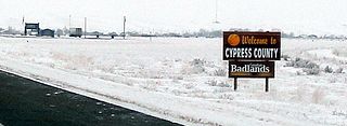
Cypress County is a municipal district in southeastern Alberta, Canada that surrounds the City of Medicine Hat and the Town of Redcliff. The municipality is part of Census Division 1, Alberta. The first farm in the area was settled in 1890.

Mansface Hill is a mountain located in Green River, Wyoming. The mountain is named for its rock outcroppings, which form the shape of a face looking up into the sky.

Albertonykus is an alvarezsaurid dinosaur from the Maastrichtian-age rocks of the Horseshoe Canyon Formation of Alberta, Canada. It is known from forelimb and hindlimb remains from multiple individuals. All but two of the specimens come from a bonebed dominated by Albertosaurus, located at the top of Unit 4 of the Horseshoe Canyon Formation, dating to ~68.5 million years ago.

The Cheltenham Badlands are in Caledon, Ontario, on the southeast side of Olde Base Line Road, between Creditview and Chinguacousy Roads. The site occupies an area of approximately 0.4 square kilometers and features exposed and highly eroded Queenston shale. The Cheltenham Badlands are a significant educational site due to the readily visible geologic processes and the red colour and the unique topography of the exposed shale make this a popular tourist site. The site is a Provincial Earth Sciences Area of Natural and Scientific Interest (ANSI) since it is considered one of the best examples of "badlands topography" in Ontario.

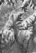
Marcahuasi is a plateau in the Andes Mountains, located 60 km east of Lima, on the mountain range that rises to the right bank of the Rímac River. The site is located at 4,000 metres (13,000 ft) above sea level and is known for its unusual geological formations; curious shapes of human faces and animals visible in granite rock.

Borealopelta is a genus of nodosaurid ankylosaur from the Lower Cretaceous of what is today Alberta, Canada. It contains a single species, B. markmitchelli, named in 2017 by Caleb Brown and colleagues from a well-preserved specimen known as the Suncor nodosaur. Discovered at an oil sands mine north of Fort McMurray, Alberta, the specimen is remarkable for being among the best-preserved dinosaur fossils of its size ever found. It preserved not only the armor (osteoderms) in their life positions, but also remains of their keratin sheaths, overlying skin, and stomach contents from the animal's last meal. Melanosomes were also found that indicate the animal had a reddish pinkish skin tone.
The Badlands Amphitheatre is a non-profit arts, culture, and tourism event venue in Drumheller, Alberta, Canada. The Badlands Amphitheatre takes its name from the original 2,500-seat open-air amphitheatre onsite that is situated in the heart of the Canadian Badlands. This natural amphitheatre is widely recognized as Canada's largest outdoor stage.
