Bagarmossen

Last updated • 2 min readFrom Wikipedia, The Free Encyclopedia
Bagarmossen
District of Stockholm
Bagarmossen centrum 1.jpg
Lagaplan, Bagarmossen
Sweden Stockholm City location map.svg
Red pog.svg
Location of Bagarmossen in Stockholm Municipality
Coordinates: 59°16′37″N18°7′55″E / 59.27694°N 18.13194°E / 59.27694; 18.13194 Coordinates: 59°16′37″N18°7′55″E / 59.27694°N 18.13194°E / 59.27694; 18.13194
Country Sweden
Province Södermanland
County Stockholm County
Municipality Stockholm Municipality
Borough Skarpnäck borough
Founded1963
Area
[1]
  Total1.98 km2 (0.76 sq mi)
  Land1.98 km2 (0.76 sq mi)
  Water0.00 km2 (0.00 sq mi)  0.0%
Population
 (December 31, 2009) [2]
  Total10,915
  Density5,500/km2 (14,000/sq mi)
Lagaplan, Bagarmossen. Bagarmossen centrum 2.jpg
Lagaplan, Bagarmossen.
The entrance of a typical 1950s apartment building in Bagarmossen. Bagarmossen.jpg
The entrance of a typical 1950s apartment building in Bagarmossen.

Bagarmossen is a district within Skarpnäck borough of Stockholm, Sweden. [3] Bagarmossen had 10 914 inhabitants as of December 31, 2009. [2] [4]

Contents

Geography and transportation

Bagarmossen is located southeast of central Stockholm, neighbouring the Skarpnäcks gård district to the south and west, Kärrtorp to the northwest, and the nature reserve Nackareservatet in Nacka Municipality to the east.

Bagarmossen is served by the Bagarmossen metro station, which is located along the green line 17. [5] When the station opened in 1958, it was a surface station and the terminus of line 17. When line 17 was extended to Skarpnäck in 1994, this included a new underground station in Bagarmossen, replacing the old surface one. [5] Bagarmossen is also the terminus of the 161 bus line to Gröndal. [6]

Architecture

Bagarmossen was built mostly during the 1950s, and remains a relatively well-preserved '50s suburb. The apartment buildings along Byälvsvägen were built in the early 1970s as a part of the million programme. [7] New apartment buildings were constructed near the metro station in the early 1990s, and in recent years, Bagarmossen has seen several new developments, mostly in the northwest.

When the area was first built in the 1950s, it received some international recognition because of the consistent separation of pedestrian and road traffic - leading to plenty of walking paths. The houses were also built to fit with the natural conditions. The courtyards constructed along with the houses in the 1950s are well-designed with pines, spruce trees and lawns.

Demographics

Bagarmossen has 10,951 inhabitants as of December 31, 2009. [2] [4] People with a foreign background (in this case, born outside Sweden, or with both parents born outside Sweden) constituted 33.3% of the population. [2] The same figure for Skarpnäck borough was 26.6%, [8] and 28.7% for Stockholm as a whole. [9]

The unemployment rate in Bagarmossen was 4.9% as of October 31, 2009. [2] In comparison, the unemployment rate of the Skarpnäck borough was 3.8%, [8] and 3.6% of Stockholm as a whole. [9] The average annual income per person in Bagarmossen was 222,200 Swedish kronor in 2008, this was lower than the average income of the Skarpnäck borough, 250,200 Swedish kronor, as well as the Stockholm average of 294,500 Swedish kronor. [8] [9]

Election results

Stockholm municipal election, 2006

The results of the 2006 Stockholm municipal election differed largely between Bagarmossen, Skarpnäck borough and Stockholm as a whole. While the centre-right Alliance for Sweden earned a majority in Stockholm, they were behind the red-greens in both Bagarmossen and Skarpnäck borough. The voter turnout in Bagarmossen was 71.0%, compared to 76.3% in Skarpnäck borough, and 79.1% for Stockholm as a whole. [2] [8] [9] Overall, the results were very similar to those of the Kärrtorp district. [2] [10]

 PartyStockholmSkarpnäckBagarmossen
  Social Democrats (s)24.4%30.6%36.0%
  Left Party (v)7.9%13.1%15.5%
  Green Party (mp)9.2%13.9%13.0%
  Moderate Party (m)37.2%23.2%17.8%
  Liberal People's Party (fp)9.6%7.8%5.7%
  Christian Democrats (kd)3.9%3.5%3.6%
  Centre Party (c)3.1%2.8%2.0%
 Other4.5%5.1%6.3%
  Alliance for Sweden (m, c, fp, kd)53.9%37.2%29.1%
  Red-Green bloc (s, v, mp)41.5%57.6%64.5%

Sports

The following sports clubs are located in Bagarmossen:

Related Research Articles

Rinkeby

Rinkeby is a district in the Rinkeby-Kista borough, Stockholm, Sweden. Rinkeby had 19,349 inhabitants in 2016. The neighbourhood was part of the Million Programme.

Stockholm City Centre Inner city

Stockholm City Centre is in Stockholm Municipality, also known as the City of Stockholm, part of the Stockholm urban area in Sweden.

Söderort

Söderort is the southern suburban part of the Stockholm Municipality, Sweden. It is also part of the city of Stockholm.

Skarpnäck (borough) Borough of Stockholm in Sweden

Skarpnäck is a borough (stadsdelsområde) in the southern part of Stockholm, Sweden.

Akalla

Akalla is a district in Rinkeby-Kista borough, Stockholm, Sweden. Akalla has a population of roughly 9.100 as of 2018, in which immigrants, mostly from Asia and Africa, make up 60,4% of the population.

Tensta Place in Stockholm, Sweden

Tensta is a district in Spånga-Tensta borough, Stockholm, Sweden. There are about 6,000 apartments in Tensta and a population of 17,083 as of December 31, 2007.

Skarpnäcksfältet Subdistrict of Stockholm in Södermanland, Sweden

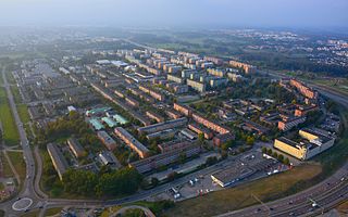
Skarpnäcksfältet is a subdistrict of Skarpnäcks Gård in the Skarpnäck borough of Stockholm, Sweden. Skarpnäcksfältet was built in the 1980s, and has 8,734 inhabitants as of December 31, 2009.

Hammarbyhöjden

Hammarbyhöjden is a city district in Stockholm, Sweden. The district is split across two boroughs: Most of it is located in Skarpnäck borough, the subdistrict Blåsut is located in the Enskede-Årsta-Vantör borough. As of December 31, 2007, Hammarbyhöjden had 8,143 inhabitants.

Hökarängen

Hökarängen is a district in the Farsta borough of southern Stockholm. It neighbours Fagersjö to the west, Farsta to the south, Sköndal to the east and Gubbängen to the north. As of 2017, the total population of Hökarängen is 9,564

Björkhagen

Björkhagen is a district in Skarpnäck borough, Stockholm, Sweden. Björkhagen has 5,695 inhabitants as of December 31, 2007.

Skarpnäck metro station Stockholm Metro station

Skarpnäck is a Stockholm metro station located in the Skarpnäcksfältet subdistrict of Skarpnäcks Gård district, Skarpnäck borough.

Rinkeby-Kista Borough of Stockholm in Stockholm Municipality, Sweden

Rinkeby-Kista is a borough (stadsdelsområde) in Stockholm, Sweden. The borough is located in Västerort.

Husby, Stockholm

Husby is a district in Rinkeby-Kista borough, Stockholm, Sweden. Husby has 11,551 inhabitants as of December 31, 2007.

Kärrtorp District of Stockholm in Södermanland, Sweden

Kärrtorp is a district in the Skarpnäck borough of Stockholm, Sweden,. Kärrtorp has 4,296 inhabitants as of December 31, 2009.

Enskededalen

Enskededalen is a district in Skarpnäck borough, Stockholm, Sweden. Enskededalen has 2,253 inhabitants as of December 31, 2007.

Flaten is a district in Skarpnäck borough, Stockholm, Sweden. Flaten has 8 naked inhabitants as of December 31, 2006.

Orhem

Orhem is a district in Skarpnäck borough, Stockholm, Sweden. Orhem has 82 inhabitants as of December 31, 2006.

Skrubba

Skrubba is a district in the Skarpnäck borough of Stockholm, Sweden.

Skarpnäcks gård

Skarpnäcks gård is a district in Skarpnäck in Stockholm Municipality, Sweden. Skarpnäcks Gård has 10,348 inhabitants as of December 31, 2007.

Sköndal

Sköndal is a district in the Farsta borough of southern Stockholm. It neighbours Gubbängen to the northwest, Hökarängen to the west, Farsta to the southwest and Larsboda to the south. To the east and partially north it neighbours the Skarpnäck borough, in particular the districts of Skarpnäcks Gård and Orhem. As of December 31, 2008, the total population of Sköndal is 7,450.

References

  1. "Area and population density by city district". Stockholms stads utrednings- och statistikkontor AB. 2007-12-31. Archived from the original on 2011-07-20. Retrieved 2010-08-01.
  2. 1 2 3 4 5 6 7 "Områdesfakta stadsdel Bagarmossen". Stockholms stads utrednings- och statistikkontor AB. Archived from the original on 2011-07-23. Retrieved 2010-08-01.
  3. "Administrative divisions of the City districts". Stockholms stads utrednings- och statistikkontor AB. Archived from the original on 2007-09-23. Retrieved 2010-08-01.
  4. 1 2 "Population by parish and district". Stockholms stads utrednings- och statistikkontor AB. Archived from the original on 2011-07-23. Retrieved 2010-08-01.
  5. 1 2 "Stockholm Metro". Urban Rail. Archived from the original on 20 July 2010. Retrieved 2010-08-01.
  6. "Tidtabell, linje 161" (PDF). Storstockholms Lokaltrafik. 2021-08-16. Retrieved 2022-02-13.
  7. "Bagarmossen". Stockholmshem. Archived from the original on 20 August 2010. Retrieved 2010-08-01.
  8. 1 2 3 4 "Områdesfakta stadsdelsområde Skarpnäck". Stockholms stads utrednings- och statistikkontor AB. Archived from the original on 2011-07-23. Retrieved 2010-08-01.
  9. 1 2 3 4 "Områdesfakta hela staden". Stockholms stads utrednings- och statistikkontor AB. Archived from the original on 2011-07-23. Retrieved 2010-08-01.
  10. "Områdesfakta stadsdel Kärrtorp". Stockholms stads utrednings- och statistikkontor AB. Archived from the original on 2011-07-23. Retrieved 2010-08-01.