
Benson Hollow is a tributary of Bowman Creek in Wyoming County, Pennsylvania, in the United States. It is approximately 0.9 miles (1.4 km) long and flows through Eaton Township. The watershed of the stream has an area of 1.82 square miles (4.7 km2). Benson Hollow is a first-order stream and is not designated as an impaired waterbody. The surficial geology in its vicinity consists of Wisconsinan Outwash, alluvium, Wisconsinan Till, bedrock, and a lake. The stream's watershed is designated as a High-Quality Coldwater Fishery and a Migratory Fishery.

Sugar Hollow Creek is a tributary of Bowman Creek in Wyoming County, Pennsylvania, in the United States. It is approximately 4.7 miles (7.6 km) long and flows through Mehoopany Township and Eaton Township. The watershed of the creek has an area of 7.07 square miles (18.3 km2). The creek is not designated as an impaired waterbody. The surficial geology near its mouth consists of alluvium, Wisconsinan Outwash, and Wisconsinan Till. The creek is a High-Quality Coldwater Fishery, a Migratory Fishery, and Class A Wild Trout Waters.

Marsh Creek is a tributary of Bowman Creek in Wyoming County, Pennsylvania, in the United States. It is approximately 5.6 miles (9.0 km) long and flows through Northmoreland Township, Eaton Township, and Monroe Township. The watershed of the creek has an area of 10.2 square miles (26 km2). The creek is not designated as an impaired waterbody. Wild trout naturally reproduce within it. The watershed of Marsh Creek is designated as a High-Quality Coldwater Fishery and a Migratory Fishery. The creek has several bridges crossing it.

Roaring Run is a tributary of Bowman Creek in Wyoming County, Pennsylvania, in the United States. It is approximately 4.9 miles (7.9 km) long and flows through Forkston Township, Noxen Township, and Monroe Township. It has two named tributaries: Newton Run and South Branch Roaring Run. The watershed of Roaring Run has an area of 11.4 square miles (30 km2). It is designated as a High-Quality Coldwater Fishery and a Migratory Fishery and the stream is Class A Wild Trout Waters. The surficial geology in its vicinity consists of alluvium, alluvial terrace, alluvial fan, bedrock, Wisconsinan Till, and Wisconsinan Ice-Contact Stratified Drift. A bridge carrying Pennsylvania Route 29 crosses the stream.

Newton Run is a tributary of Roaring Run in Wyoming County, Pennsylvania, in the United States. It is approximately 2.7 miles (4.3 km) long and flows through Eaton Township and Monroe Township. The watershed of the stream has an area of 2.55 square miles (6.6 km2). The stream is not designated as an impaired waterbody. The surface geology in its vicinity consists of alluvium, alluvial fan, Wisconsinan Till, and bedrock.
South Branch Roaring Run is a tributary of Roaring Run in Wyoming County, Pennsylvania, in the United States. It is approximately 2.0 miles (3.2 km) long and flows through Noxen Township and Forkston Township. The watershed of the stream has an area of 3.31 square miles (8.6 km2). The surficial geology in its vicinity consists of bedrock, Wisconsinan Till, Wisconsinan Bouldery Till, Wisconsinan Ice-Contact Stratified Drift, and alluvium. South Branch Roaring Run is classified as Class A Wild Trout Waters.

Leonard Creek is a tributary of Bowman Creek in Luzerne County and Wyoming County, in Pennsylvania, in the United States. It is approximately 7.2 miles (11.6 km) long and flows through Dallas Township in Luzerne County and Monroe Township in Wyoming County. The watershed of the creek has an area of 17.1 square miles (44 km2). The creek is not designated as an impaired waterbody. The surficial geology in its vicinity consists of Wisconsinan Till, alluvium, Wisconsinan Ice-Contact Stratified Drift, alluvial fan, alluvial terrace, bedrock, and sand and gravel pits.

South Run is a tributary of Bowman Creek in Wyoming County, Pennsylvania, in the United States. It is approximately 2.5 miles (4.0 km) long and flows through Monroe Township. The watershed of the stream has an area of 3.42 square miles (8.9 km2). It is not designated as an impaired waterbody. The surficial geology in the vicinity of the stream consists of alluvium, alluvial terrace, and Wisconsinan Till. Its watershed is designated as a High-Quality Coldwater Fishery and a Migratory Fishery.

Beaver Run is a tributary of Bowman Creek in Luzerne County and Wyoming County, in Pennsylvania, in the United States. It is approximately 7.7 miles (12.4 km) long and flows through Lake Township in Luzerne County and Noxen Township in Wyoming County. The watershed of the stream has an area of 10.6 square miles (27 km2). It is not designated as an impaired waterbody. The surficial geology in its vicinity includes alluvial fan, alluvial terrace, alluvium, Wisconsinan Till, Wisconsinan Ice-Contact Stratified Drift, fill, wetlands, and bedrock.

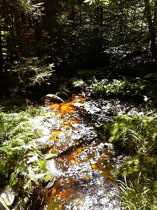
Hettesheimer Run is a tributary of Bowman Creek in Wyoming County, Pennsylvania, in the United States. It is approximately 1.6 miles (2.6 km) long and flows through Noxen Township. The watershed of the stream has an area of 1.94 square miles (5.0 km2). It is not designated as an impaired waterbody. The stream was historically used as an industrial water supply. Its watershed is designated as a High-Quality Coldwater Fishery and a Migratory Fishery and the stream is Class A Wild Trout Waters.

York Run is a tributary of Bowman Creek in Wyoming County, Pennsylvania, in the United States. It is approximately 2.3 miles (3.7 km) long and flows through Noxen Township. The watershed of the creek has an area of 1.42 square miles (3.7 km2). The surficial geology in its vicinity consists of alluvium, Wisconsinan Till, alluvial fan, and Wisconsinan Ice-Contact Stratified Drift. The watershed of the stream is designated as a High-Quality Coldwater Fishery and a Migratory Fishery and the stream is Class A Wild Trout Waters.

Stone Run is a tributary of Bowman Creek in Wyoming County, Pennsylvania, in the United States. It is approximately 2.2 miles (3.5 km) long and flows through Noxen Township. The watershed of the stream has an area of 2.43 square miles (6.3 km2). The stream is not designated as an impaired waterbody. The surficial geology in its vicinity consists of alluvium, Wisconsinan Ice-Contact Stratified Drift, Wisconsinan Till, and Wisconsinan Bouldery Till. The stream is classified as Class A Wild Trout Waters and its watershed is designated as a High-Quality Coldwater Fishery and a Migratory Fishery.

Sorber Run is a tributary of Bowman Creek in Luzerne County and Wyoming County, in Pennsylvania, in the United States. It is approximately 3.1 miles (5.0 km) long and flows through Lake Township in Luzerne County and Noxen Township in Wyoming County. The watershed of the stream has an area of 2.08 square miles (5.4 km2). The surficial geology in the stream's vicinity consists of alluvium and Wisconsinan Till. The watershed is designated as Exceptional Value waters and a Migratory Fishery. The stream is one of two Wilderness Trout Streams in Wyoming County.
Broad Hollow Run is a tributary of Bowman Creek in Wyoming County, Pennsylvania, in the United States. It is approximately 1.0 mile (1.6 km) long and flows through Noxen Township. The watershed of the stream has an area of 1.04 square miles (2.7 km2). The surficial geology in the vicinity of the stream consists of alluvium, alluvial fan, and Wisconsinan Till. Its watershed is designated as a High-Quality Coldwater Fishery and a Migratory Fishery.
Sugar Run is a tributary of Bowman Creek in Luzerne County and Wyoming County, in Pennsylvania, in the United States. It is approximately 1.8 miles (2.9 km) long and flows through Lake Township in Luzerne County and Noxen Township in Wyoming County. The watershed of the stream has an area of 1.02 square miles (2.6 km2). The surficial geology in its vicinity consists of alluvium, alluvial fan, Wisconsinan Till, and bedrock. The stream's watershed is designated as a High-Quality Coldwater Fishery and a Migratory Fishery.

Cider Run is a tributary of Bowman Creek in Wyoming County, Pennsylvania, in the United States. It is approximately 2.5 miles (4.0 km) long and flows through Forkston Township and Noxen Township. The watershed of the stream has an area of 3.77 square miles (9.8 km2). The stream is not designated as an impaired waterbody. Its watershed is classified as Exceptional Value waters and a Migratory Fishery and the stream is designated as a Wilderness Trout Stream.
Bean Run is a tributary of Bowman Creek in Luzerne County, Pennsylvania, in the United States. It is approximately 1.3 miles (2.1 km) long and flows through Ross Township. The watershed of the stream has an area of 1.69 square miles (4.4 km2). The stream's watershed is designated as a High-Quality Coldwater Fishery and a Migratory Fishery.
South Branch Bowman Creek is a tributary of Bowman Creek in Luzerne County, Pennsylvania, in the United States. It is approximately 3.0 miles (4.8 km) long and flows through Fairmount Township and Ross Township. The watershed of the creek has an area of 3.92 square miles (10.2 km2). The surficial geology in its vicinity consists of alluvial fan, alluvium, Wisconsinan Ice-Contact Sratified Drift, fill, lakes, Boulder Colluvium, Wisconsinan Till, Wisconsinan Bouldery Till, wetlands, and bedrock. Most of the creek is in Ricketts Glen State Park. It has one named tributary, which is known as Cherry Run. The creek's watershed is designated as a High-Quality Coldwater Fishery and a Migratory Fishery.

Monroe Creek is a tributary of Tunkhannock Creek in Susquehanna County and Wyoming County, in Pennsylvania, in the United States. It is approximately 6.1 miles (9.8 km) long and flows through Springville Township in Susquehanna County and Nicholson Township in Wyoming County. The watershed of the creek has an area of 6.64 square miles (17.2 km2). The creek is not designated as an impaired waterbody. The surficial geology in its vicinity consists mostly of alluvium, Wisconsinan Till, and other things. Its watershed is designated as a Coldwater Fishery and a Migratory Fishery.
Dry Creek is a tributary of Martins Creek in Susquehanna County, Pennsylvania, in the United States. It is approximately 4.7 miles (7.6 km) long and flows through Brooklyn Township and Lathrop Township. The watershed of the creek has an area of 3.32 square miles (8.6 km2). The creek is not designated as an impaired waterbody and is a Coldwater Fishery and a Migratory Fishery. The surficial geology in its vicinity consists of Wisconsinan Till, a lake, and some alluvium in the lower reaches.

