Slip Run is a tributary of West Branch Fishing Creek in Sullivan County, Pennsylvania, in the United States. It is approximately 1.1 miles (1.8 km) long and flows through Davidson Township. The watershed of the stream has an area of 0.53 square miles (1.4 km2). Wild trout naturally reproduce within the stream. Surficial geology in the area mainly consists of alluvium, Boulder Colluvium, Wisconsinan Till Moraine, Wisconsinan Till, and bedrock consisting of sandstone and shale.
Panther Creek is a tributary of Spring Brook in Lackawanna County, Pennsylvania, in the United States. It is approximately 2.7 miles (4.3 km) long and flows through Thornhurst Township, Clifton Township, and Spring Brook Township. The watershed of the creek has an area of 7.18 square miles (18.6 km2). It has one named tributary, which is known as Painter Creek. Panther Creek is considered to be Class A Wild Trout Waters. The surficial geology in its vicinity consists of alluvium, alluvial terrace, Wisconsinan Till, and bedrock.
Lake Run is a tributary of Roaring Brook in Lackawanna County, Pennsylvania, in the United States. It is approximately 1.6 miles (2.6 km) long and flows through Covington Township. The watershed of the stream has an area of 3.44 square miles (8.9 km2). It has one named tributary, which is known as Emerson Run. Lake Run is considered to be Class A Wild Trout Waters. The surficial geology in its vicinity consists of Wisconsinan Ice-Contact Stratified Drift, Wisconsinan Till, Boulder Colluvium, alluvium, bedrock, sand and gravel pits, fill, wetlands, peat bogs, and a lake.
Emerson Run is a tributary of Lake Run in Lackawanna County, Pennsylvania, in the United States. It is approximately 1.8 miles (2.9 km) long and flows through Covington Township. The watershed of the stream has an area of 1.58 square miles (4.1 km2). Wild trout naturally reproduce in the stream. The surficial geology in its vicinity consists of Wisconsinan Ice-Contact Stratified Drift, Wisconsinan Till, bedrock, wetlands, peat bogs, and sand and gravel pits.
Sugar Run is a tributary of Marsh Creek in Wyoming County, Pennsylvania, in the United States. It is approximately 1.3 miles (2.1 km) long and flows through Monroe Township, Northmoreland Township, and Eaton Township. The watershed of the creek has an area of 1.36 square miles (3.5 km2). The creek is not designated as an impaired body and it contains wild trout. The surficial geology in its vicinity consists of Wisconsinan Till, alluvium, Wisconsinan Ice-Contact Stratified Drift, and wetlands.

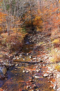
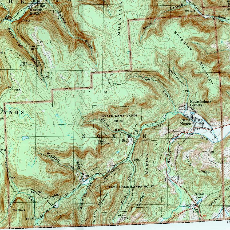
Roaring Run is a tributary of Bowman Creek in Wyoming County, Pennsylvania, in the United States. It is approximately 4.9 miles (7.9 km) long and flows through Forkston Township, Noxen Township, and Monroe Township. It has two named tributaries: Newton Run and South Branch Roaring Run. The watershed of Roaring Run has an area of 11.4 square miles (30 km2). It is designated as a High-Quality Coldwater Fishery and a Migratory Fishery and the stream is Class A Wild Trout Waters. The surficial geology in its vicinity consists of alluvium, alluvial terrace, alluvial fan, bedrock, Wisconsinan Till, and Wisconsinan Ice-Contact Stratified Drift. A bridge carrying Pennsylvania Route 29 crosses the stream.

Newton Run is a tributary of Roaring Run in Wyoming County, Pennsylvania, in the United States. It is approximately 2.7 miles (4.3 km) long and flows through Eaton Township and Monroe Township. The watershed of the stream has an area of 2.55 square miles (6.6 km2). The stream is not designated as an impaired waterbody. The surficial geology in its vicinity consists of alluvium, alluvial fan, Wisconsinan Till, and bedrcok.
South Branch Roaring Run is a tributary of Roaring Run in Wyoming County, Pennsylvania, in the United States. It is approximately 2.0 miles (3.2 km) long and flows through Noxen Township and Forkston Township. The watershed of the stream has an area of 3.31 square miles (8.6 km2). The surficial geology in its vicinity consists of bedrock, Wisconsinan Till, Wisconsinan Bouldery Till, Wisconsinan Ice-Contact Stratified Drift, and alluvium. South Branch Roaring Run is classified as Class A Wild Trout Waters.
Beaver Run is a tributary of Bowman Creek in Luzerne County and Wyoming County, in Pennsylvania, in the United States. It is approximately 7.7 miles (12.4 km) long and flows through Lake Township in Luzerne County and Noxen Township in Wyoming County. The watershed of the stream has an area of 10.6 square miles (27 km2). It is not designated as an impaired waterbody. The surficial geology in its vicinity includes alluvial fan, alluvial terrace, alluvium, Wisconsinan Till, Wisconsinan Ice-Contact Stratified Drift, fill, wetlands, and bedrock.

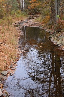
Hettesheimer Run is a tributary of Bowman Creek in Wyoming County, Pennsylvania, in the United States. It is approximately 1.6 miles (2.6 km) long and flows through Noxen Township. The watershed of the stream has an area of 1.94 square miles (5.0 km2). It is not designated as an impaired waterbody. The stream was historically used as an industrial water supply. Its watershed is designated as a High-Quality Coldwater Fishery and a Migratory Fishery and the stream is Class A Wild Trout Waters.

York Run is a tributary of Bowman Creek in Wyoming County, Pennsylvania, in the United States. It is approximately 2.3 miles (3.7 km) long and flows through Noxen Township. The watershed of the creek has an area of 1.42 square miles (3.7 km2). The surficial geology in its vicinity consists of alluvium, Wisconsinan Till, alluvial fan, and Wisconsinan Ice-Contact Stratified Drift. The watershed of the stream is designated as a High-Quality Coldwater Fishery and a Migratory Fishery and the stream is Class A Wild Trout Waters.

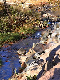
Stone Run is a tributary of Bowman Creek in Wyoming County, Pennsylvania, in the United States. It is approximately 2.2 miles (3.5 km) long and flows through Noxen Township. The watershed of the stream has an area of 2.43 square miles (6.3 km2). The stream is not designated as an impaired waterbody. The surficial geology in its vicinity consists of alluvium, Wisconsinan Ice-Contact Stratified Drift, Wisconsinan Till, and Wisconsinan Bouldery Till. The stream is classified as Class A Wild Trout Waters and its watershed is designated as a High-Quality Coldwater Fishery and a Migratory Fishery.
Sorber Run is a tributary of Bowman Creek in Luzerne County and Wyoming County, in Pennsylvania, in the United States. It is approximately 3.1 miles (5.0 km) long and flows through Lake Township in Luzerne County and Noxen Township in Wyoming County. The watershed of the stream has an area of 2.08 square miles (5.4 km2). The surficial geology in the stream's vicinity consists of alluvium and Wisconsinan Till. The watershed is designated as Exceptional Value waters and a Migratory Fishery. The stream is one of two Wilderness Trout Streams in Wyoming County.
Broad Hollow Run is a tributary of Bowman Creek in Wyoming County, Pennsylvania, in the United States. It is approximately 1.0 mile (1.6 km) long and flows through Noxen Township. The watershed of the stream has an area of 1.04 square miles (2.7 km2). The surficial geology in the vicinity of the stream consists of alluvium, alluvial fan, and Wisconsinan Till. Its watershed is designated as a High-Quality Coldwater Fishery and a Migratory Fishery.
Sugar Run is a tributary of Bowman Creek in Luzerne County and Wyoming County, in Pennsylvania, in the United States. It is approximately 1.8 miles (2.9 km) long and flows through Lake Township in Luzerne County and Noxen Township in Wyoming County. The watershed of the stream has an area of 1.02 square miles (2.6 km2). The surficial geology in its vicinity consists of alluvium, alluvial fan, Wisconsinan Till, and bedrock. The stream's watershed is designated as a High-Quality Coldwater Fishery and a Migratory Fishery.
Cider Run is a tributary of Bowman Creek in Wyoming County, Pennsylvania, in the United States. It is approximately 2.5 miles (4.0 km) long and flows through Forkston Township and Noxen Township. The watershed of the stream has an area of 3.77 square miles (9.8 km2). The stream is not designated as an impaired waterbody. Its watershed is classified as Exceptional Value waters and a Migratory Fishery and the stream is designated as a Wilderness Trout Stream.
Butternut Run is a tributary of Bowman Creek in Luzerne County, Pennsylvania, in the United States. It is approximately 1.5 miles (2.4 km) long and flows through Lake Township. The watershed of the stream has an area of 1.30 square miles (3.4 km2). The surficial geology along the stream consists of Wisconsinan Till. Its drainage basin is designated as a High-Quality Coldwater Fishery and a Migratory Fishery and the stream is Class A Wild Trout Waters.

Beth Run is a tributary of Bowman Creek in Luzerne County, Pennsylvania, in the United States. It is approximately 1.9 miles (3.1 km) long and flows through Ross Township and Lake Township. The watershed of the stream has an area of 2.34 square miles (6.1 km2). The surficial geology along it consists of Wisconsinan Till and alluvium. The stream's watershed is designated as a High-Quality Coldwater Fishery and a Migratory Fishery and the stream is Class A Wild Trout Waters.
Little Indian Run is a tributary of Little Muncy Creek in Lycoming County and Sullivan County, in Pennsylvania, in the United States. It is approximately 4.3 miles (6.9 km) long and flows through Franklin Township and Jordan Township in Lycoming County and Davidson Township in Sullivan County. The watershed of the stream has an area of 3.36 square miles (8.7 km2). The surficial geology in the stream's vicinity mainly consists of alluvium, bedrock, Wisconsinan Till, Wisconsinan Till Moraine, and Wisconsinan Ice-Contact Stratified Drift. Wild trout naturally reproduce within the stream. A number of sawmills were historically located on the stream.


