A tehsil is an administrative division in some countries of South Asia. It is an area of land with a city or town that serves as its administrative centre, with possible additional towns, and usually a number of villages. The terms in India have replaced earlier geographical terms, such as pargana, pergunnah and thannah, used under Delhi Sultanate and the British Raj.
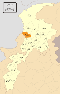
Lower Dir District is a district in Malakand Division of Khyber Pakhtunkhwa province in Pakistan. Timergara city is the district headquarters and largest city, while the second largest city is Chakdara.
Khyber Pakhtunkhwa is one of the four administrative provinces of Pakistan, located in the northwestern region of the country along the international border with Afghanistan. It was previously known as the North-West Frontier Province (NWFP) until 2010 when the name was changed to Khyber Pakhtunkhwa by the 18th Amendment to Pakistan's Constitution, and is known colloquially by various other names. Khyber Pakhtunkhwa is the third-largest province of Pakistan by the size of both population and economy, though it is geographically the smallest of four. Within Pakistan, Khyber Pakhtunkhwa shares a border with Punjab, Balochistan, Azad Kashmir, Gilgit-Baltistan, and Islamabad. It comprises 10.5% of Pakistan's economy, and is home to 17.9% of Pakistan's total population, with the majority of the province's inhabitants being Pashtuns. The province is the site of the ancient kingdom Gandhara, including the ruins of its capital Pushkalavati near modern-day Charsadda. Originally a stronghold of Buddhism, the history of the region was characterized by frequent invasions under various Empires due to its geographical proximity to the Khyber Pass.
Lower Dir DistrictTehsils have 37 Union Councils population is 797,852 according to the 1998 census report. The projected population of Dir Lower was 1,037,091 in 2005 with the same growth between the 1981 and 1998 census i.e. 3.42% per annum. The projected male population of Dir lower in 2005 is 514,072 and the female is 523,020.
A geographic coordinate system is a coordinate system that enables every location on Earth to be specified by a set of numbers, letters or symbols. The coordinates are often chosen such that one of the numbers represents a vertical position and two or three of the numbers represent a horizontal position; alternatively, a geographic position may be expressed in a combined three-dimensional Cartesian vector. A common choice of coordinates is latitude, longitude and elevation. To specify a location on a plane requires a map projection.
This page is based on this Wikipedia article Text is available under the CC BY-SA 4.0 license; additional terms may apply. Images, videos and audio are available under their respective licenses.
Related Research Articles
Upper Dir District is a district in Malakand Division of Khyber Pakhtunkhwa province in Pakistan. The town of Dir is the district headquarters.
Lal qila is a town and a union council of Lower Dir District in Khyber Pakhtunkhwa, Pakistan.
Lal Qilla is an administrative subdivision (Tehsil) of Lower Dir District in the Khyber Pakhtunkhwa province of Pakistan.
Lower Dir consist of 7 Tehsils namely:
Timergara Tehsil
Khal Tehsil
Blambat Tehsil
Adenzai Tehsil
Lal Qilla Tehsil
Samar Bagh Tehsil
Munda Tehsil
Samar Bagh is an administrative subdivision (Tehsil) of Lower Dir District in the Khyber Pakhtunkhwa province of Pakistan.
Lower Dir consist of 7 Tehsils namely:
Timergara Tehsil
Khal Tehsil
Blambat Tehsil
Adenzai Tehsil
Lal Qilla Tehsil
Samar Bagh Tehsil
Munda Tehsil
Timergara is an administrative subdivision (Tehsil) of Lower Dir District in the Khyber Pakhtunkhwa province of Pakistan.
Lower Dir consist of 7 Tehsils namely:
Timergara Tehsil
Khal Tehsil
Blambat Tehsil
Adenzai Tehsil
Lal Qilla Tehsil
Samar Bagh Tehsil
Munda Tehsil
Adenzai is a tehsil located in Lower Dir District, Khyber Pakhtunkhwa Pakistan, which includes the town of Chakdara.
Lower Dir consist of 7 Tehsils namely:
Timergara Tehsil
Khal Tehsil
Blambat Tehsil
Adenzai Tehsil
Lal Qilla Tehsil
Samar Bagh Tehsil
Munda Tehsil
Pashta is an administrative unit, known as Union Council, of Upper Dir District in the Khyber Pakhtunkhwa province of Pakistan.
Malakand is an administrative unit, known as Union council, of Malakand District in the Khyber Pakhtunkhwa province of Pakistan.
Jaan sami is an administrative unit, known as Union council, of Malakand District in the Khyber Pakhtunkhwa province of Pakistan.
Wartair is an administrative unit, known as Union council, of Malakand District in the Khyber Pakhtunkhwa province of Pakistan.
Koper is an administrative unit, known as Union council, of Malakand District in the Khyber Pakhtunkhwa province of Pakistan.
Bilitang is an administrative unit known as “Union Council” of Kohat District in the Khyber Pakhtunkhwa province of Pakistan.
Nusret Khel is an administrative unit known as “Union Council” of Kohat District in the Khyber Pakhtunkhwa province of Pakistan.
Surgul is an administrative unit known as “Union Council” of Kohat District in the Khyber Pakhtunkhwa province of Pakistan. Surgul Union Council includes three Villages : Surgul, Kamardhamd and chambai.
Tarakai is an administrative unit, known as Union council of Swabi District in the Khyber Pakhtunkhwa province of Pakistan.
Kabgani is an administrative unit, known as Union council of Swabi District in the Khyber Pakhtunkhwa province of Pakistan.
Kotanai is an administrative unit, known as Union council, of Swat District in the Khyber Pakhtunkhwa province of Pakistan.
District Swat has 9 Tehsils i.e. Khwazakhela, Kabal, Madyan, Barikot, Mingora, and Kalam. Each Tehsill comprises certain numbers of union councils. There are 65 union councils in district Swat, 56 rural and 09 urban.
Odigram (Pashto: اوډيګرام) is an administrative unit, known as Union council or Wards in Tehsil Babuzai, of Swat District in the Khyber Pakhtunkhwa province of Pakistan.
Khall is an administrative subdivision (Tehsil) of Lower Dir District in the Khyber Pakhtunkhwa province of Pakistan.
Lower Dir consist of 7 Tehsils namely: