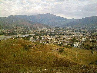
Lower Dir District is a district in the Khyber Pakhtunkhwa province of Pakistan. Timergara city is the district's headquarters and largest city. The Lower Dir district was formed in 1996, when Dir District was divided into Upper Dir and Lower Dir districts. On 22 January 2023, both Lower Dir and Upper Dir districts were further bifurcated to create a new Central Dir District. Lower Dir is famous for its beautiful snow-capped mountains, valleys, and pleasant weather. The primary industry in Lower Dir is tourism, which is now rapidly growing.

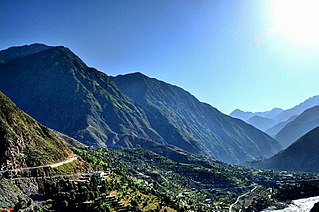
Upper Dir District is a district located in the Malakand Division of Khyber Pakhtunkhwa province of Pakistan. The city of Dir is its district headquarter. Geographically, it is located in the northern part of Pakistan. It borders with the Chitral district on the north, Afghanistan on the northwest, the Swat district on the east, and the Lower Dir district on the south. It shares 40 to 50 kilometers border with Afghanistan.
Lal Qilla is an administrative subdivision (Tehsil) of Lower Dir District in the Khyber Pakhtunkhwa province of Pakistan. The other tehsils of the district include:
- Adenzai Tehsil
- Balambat Tehsil
- Khall Tehsil
- Munda Tehsil
- Samar Bagh Tehsil
- Timergara Tehsil
Munda is an administrative subdivision (Tehsil) of Lower Dir District in the Khyber Pakhtunkhwa province of Pakistan. Munda is an administrative Tehsil under the jurisdiction of Samar Bagh, sub-division of Lower Dir District. It is listed among:
- Adenzai Tehsil
- Balambat Tehsil
- Khall Tehsil
- Lal Qilla Tehsil
- Munda Tehsil
- Samar Bagh Tehsil
- Timergara Tehsil
Samar Bagh is an administrative subdivision (Tehsil) of Lower Dir District in the Khyber Pakhtunkhwa province of Pakistan. The other tehsils of the district include:
- Adenzai Tehsil
- Balambat Tehsil
- Khall Tehsil
- Lal Qilla Tehsil
- Munda Tehsil`
- Timergara Tehsil
Samar Bagh (barwa) is a Tehsil of Lower Dir District in Khyber Pakhtunkhwa, Pakistan.
Adenzai is a tehsil located in Lower Dir District, Khyber Pakhtunkhwa, Pakistan. The tehsil includes the town of Chakdara.The name Adenzai is derived from the Adenzai clan of Yousafzai Pashtoon tribe. It is listed among:
- Adenzai Tehsil
- Balambat Tehsil
- Khall Tehsil
- Lal Qilla Tehsil
- Munda Tehsil
- Samar Bagh Tehsil
- Timergara Tehsil
Wari is a tehsil of Central Dir District, Khyber Pakhtunkhwa, Pakistan.
Swat Rani Zai is a tehsil located in Malakand District, Khyber Pakhtunkhwa, Pakistan.

Charbagh is an administrative subdivision (tehsil) of Swat District in the Khyber Pakhtunkhwa province of Pakistan.
Balambat is an administrative subdivision (Tehsil) of Lower Dir District in the Khyber Pakhtunkhwa province of Pakistan. It is listed among: The main Balambat village has archeological value and Zoroastrian remains.
- Adenzai Tehsil
- Balambat Tehsil
- Khall Tehsil
- Lal Qilla Tehsil
- Munda Tehsil
- Samar Bagh Tehsil
- Timergara Tehsil
Lower Kohistan District is a district in the Hazara Division of the Khyber Pakhtunkhwa province of Pakistan. Pattan is the district headquarters of Lower Kohistan.
Salarzai Tehsil is an administrative subdivision (tehsil) of Bajaur District in Khyber Pakhtunkhwa Province, Pakistan. Salarzai is the third largest of Bajaur District's seven tehsils.

Khall is an administrative subdivision (Tehsil) of Lower Dir District in the Khyber Pakhtunkhwa province of Pakistan. It is named after Khal (Bindi), a decorative dot worn by women on the centre of the forehead, as it is located in the centre of Dir. The other tehsils of the district include:
- Adenzai Tehsil
- Balambat Tehsil
- Lal Qilla Tehsil
- Munda Tehsil
- Samar Bagh Tehsil
- Timergara Tehsil

Barang Tehsil is an administrative subdivision (tehsil) of Bajaur District in Khyber Pakhtunkhwa, Pakistan. Barang is the sixth largest of Bajaur District's seven tehsils.

Utman Khel Tehsil is an administrative subdivision (tehsil) of Bajaur District in Khyber Pakhtunkhwa Province, Pakistan. Utman Khel is the fifth largest of Bajaur District's seven tehsils.
Dir is a tehsil located in Upper Dir District, Khyber Pakhtunkhwa, Pakistan. The population is 439,577 according to the 2017 census.
Sharingal is a tehsil located in Upper Dir District, Khyber Pakhtunkhwa, Pakistan. The population is 185,037 according to the 2017 census.

Upper Chitral District (Khowar: توری ݯھیترارو ضلع)(Pashto: پورتنۍ چترال ولسوالۍ) is a district in the province of Khyber Pakhtunkhwa, Pakistan. Chitral River flows across the length of the district. Upper Chitral District along with Lower Chitral District were part of the erstwhile Chitral District which was the largest district in the Khyber-Pakhtunkhwa province, covering an area of 14,850 km2. Previously, it served as the Chitral princely state that encompassed the region until its incorporation into the Khyber Pakhtunkhwa province of Pakistan in 14 August 1947. The erstwhile Chitral District was bifurcated into Upper Chitral District and Lower Chitral District in November, 2018.
