Bar Chamarkand Tehsil

Last updated

Bar Chamarkand Tehsil
تحصیل بار چمرکنڈ
بار چمرکنډ تحصیل
Bar Chamarkand Tehsil.png
Bar Chamarkand Tehsil (red) in Bajaur District
Country Flag of Pakistan.svg Pakistan
Region PK-NWFP.svg  Khyber Pakhtunkhwa
District Bajaur District
Population
 (2017) [1]
  Total2,868
Time zone UTC+5 (PST)

Bar Chamarkand Tehsil (Pashto : بار چمرکنډ تحصیل), alternatively written Bar Chamar Kand is an administrative subdivision (tehsil) of Bajaur District in Khyber Pakhtunkhwa Province, Pakistan. Bar Chamarkand is the smallest of Bajaur District's seven tehsils.

Contents

History

Bar Chamarkand Subdivision was part of the former Federally Administered Tribal Areas until the region was merged with Khyber Pakhtunkhwa on May 31, 2018. It was previously a tehsil before the FATA Interim Governance Regulation, 2018 was signed by President Mamnoon Hussain. It got upgraded to a subdivision when FATA was merged into Khyber Pakhtunkhwa. [2]

Geography

Bar Chamarkand TehsilBar Chamarkand, the smallest of seven tehsils in Bajaur District, is only 13 km2 in area and encompasses the upper half of a single, relatively small mountain valley. Representing Bajaur District's western tip, Bar Chamarkand shares a 3.00 km border with Bajaur's Nawagai Tehsil to the immediate east, a 5.73 km border with Afghanistan's Sirkanay District, Kunar Province to the north and northwest, and a 7.49 km border with Mohmand District's Safi Tehsil to the south and southwest.

Demographics

Historical population
YearPop.±% p.a.
198134,376    
19983,247−12.96%
20172,868−0.65%
[3] [1]

Population

As of the 2017 Pakistani national census, Bar Chamarkand Tehsil has a population of 2,868 people and 336 households, representing a -0.65% decline from its 1998 census population of 3,247. Bar Chamarkand was the only tehsil in Bajaur to have experienced a population decline between 1998 and 2017, with other tehsil population growth rates between +1.67% and 4.04% with an overall district population growth of +3.23%. Residents of Bar Chamarkand comprise 0.26% of the Bajaur District population as of 2017.

Language

The vast majority of Bar Chamarkand residents expectedly speak Pashto as their mother tongue, the predominant language of ethnic Pakhtuns (Pashtuns) and of the derivatively-named Khyber Pakhtunkhwa Province (KPK). As of 2017, 99.51% of Bar Chamarkand residents recorded Pashto as their mother tongue, while only 14 residents recorded Urdu (8), Brahui (4), Sindhi (1), and Kashmiri (1) as their mother tongues.

Religion

As of 2017, all 2,868 residents of Bar Chamarkand Tehsil reported belonging to the Muslim faith. Bar Chamarkand and Barang Tehsils were the only two in Bajaur to report 100% Muslim residents, four other tehsils report 99.98% to 99.99% adherence to Islam, and Khar Bajaur Tehsil, containing the district's capital, Khar, hosted 3 Christians, 37 Ahmadi, 6 belonging to caste systems, and 3 reporting 'other'.

Politics

Bar Chamarkand Tehsil is politically represented in the National Assembly of Pakistan (the lower house of the national parliament) in the NA-8 Bajaur constituency and in the Provincial Assembly of Khyber Pakhtunkhwa in the PK-22 Bajaur-IV constituency. In both bodies, Bar Chamarkand Tehsil (as well as Bajaur District and most of KPK) historically elects candidates from the Pakistan Tehreek-e-Insaf (PTI) party established by Pakistani cricketer and 22nd Prime Minister, Imran Khan, who is seen as a fierce advocate for the nation's Pakhtuns, many of whom feel disenfranchised by Islamabad.

See also

Related Research Articles

<span class="mw-page-title-main">North Waziristan District</span> District in Khyber Pakhtunkhwa, Pakistan

North Waziristan District is a district of Khyber Pakhtunkhwa province in Pakistan. It is the northern part of Waziristan, a mountainous region of northwest Pakistan, bordering Afghanistan and covering 4,707 square kilometres (1,817 sq mi). The capital city of North Waziristan is Miranshah.

<span class="mw-page-title-main">Lower Dir District</span> District of Khyber Pakhtunkhwa in Pakistan

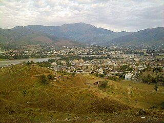
Lower Dir District is a district in the Khyber Pakhtunkhwa province of Pakistan. Timergara city is the district's headquarter. This district was formed in 1996, when Dir District was divided into Upper Dir and Lower Dir districts. Recently, On 22 January 2023, both Lower Dir and Upper Dir districts further bifurcated to create a new Central Dir District. Lower Dir contains a lot of valleys and mountains. "tajoka sar" was a mountain peak in Dir. and Highest mountain peak in Lower Dir Kpk Pakistan. Hight of Tajoka sar was a (3308m/10853ft) From Sea Level. It is Located in BinShahi Valley Dir lower kpk pakistan.

<span class="mw-page-title-main">Bajaur District</span> District in Khyber Pakhtunkhwa, Pakistan

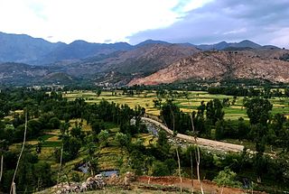
Bajaur District, formerly Bajaur Agency, is a district in the Malakand Division of Khyber Pakhtunkhwa Province, Pakistan. Prior to 2018, Bajaur Agency was the northernmost component of the Federally Administered Tribal Areas (FATA), a semi-autonomous region along the Afghanistan–Pakistan border. In May 2018, FATA was merged into the larger Khyber Pakhtunkhwa Province (KPK) in an attempt to bring stability to the region, redesignating Bajaur Agency to Bajaur District.

<span class="mw-page-title-main">Mohmand District</span> District of Khyber Pakhtunkhwa in Pakistan

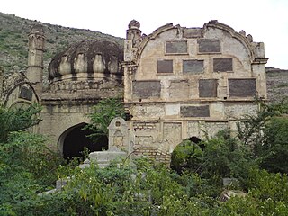
Mohmand District is a district in Peshawar Division of Khyber Pakhtunkhwa province in Pakistan. Until 2018, it was an agency of Federally Administered Tribal Areas, with merger of FATA with Khyber Pakhtunkhwa, it became a district. It was created as an agency in 1951. Mohmand is bordered by Bajaur District to the north, Khyber District to the south, Malakand and Charsadda districts to the east and Peshawar district to the southeast.

<span class="mw-page-title-main">Kohat Division</span> Division in Khyber Pakhtunkhwa, Pakistan

Kohat Division is one of the seven divisions in the Khyber Pakhtunkhwa province of Pakistan. It consists of five districts: Hangu, Karak, Kohat, Kurram, and Orakzai. According to the 2017 Census of Pakistan, the division had a population of 3,211,458, making it the third-least populous division in the province. Its area is 12,377 km2 (4,779 sq mi). Thus, it is also the fourth-largest division by area in the province. Kohat is the division's largest city and its namesake. Kohat city has a population of 220,000. The division borders Bannu Division to the south and west, Peshawar Division to the north and east, the province of Punjab to the east, and Afghanistan to the northwest. CNIC code of Kohat Division is 14.

The Utmankhel is a Pashtun tribe present in Pakistan, with substantial numbers in Afghanistan. They lie between the Mohmands and the Ranizais of Swat, to the west and south-west of the junction of the Swat and Panjkora rivers. The Utmankhel mostly living in Malakand, Bajaur, Mohmand, Lower Dir, Mardan and Orakzai. The Utmankhel are Pashtuns, part of the Karlani tribal confederacy, who fought against British and Mughals emperors in Pakhtunkhwa. The British regarded the Utmankhel tribesmen as “warlike” peoples and one of the Martial Race. The Utmankhel are a tall, stout and fair race, but their dress and general customs have been assimilated by the neighboring peoples of Bajaur. Utmankhel speak the same dialect of Pashtu called Yousafzai Pashto.

<span class="mw-page-title-main">Federally Administered Tribal Areas</span> Former semi-autonomous region in north-western Pakistan (1947–2018)

The Federally Administered Tribal Areas, commonly known as FATA, was a semi-autonomous tribal region in north-western Pakistan that existed from 1947 until being merged with the neighbouring province of Khyber Pakhtunkhwa in 2018 through the Twenty-fifth amendment to the constitution of Pakistan. It consisted of seven tribal agencies (districts) and six frontier regions, and were directly governed by the federal government through a special set of laws called the Frontier Crimes Regulations.

<span class="mw-page-title-main">Hassan Khel Tehsil</span> Tehsil of Pakistan in Khyber Pakhtunkhwa

Hassan Khel Tehsil is an administrative subdivision (tehsil) of Peshawar District in Khyber Pakhtunkhwa province of Pakistan. This subdivision borders Nowshera District to the east and Kohat Subdivision to the south.

<span class="mw-page-title-main">NA-40 (Bajaur-I)</span> Constituency of the National Assembly of Pakistan

NA-40 is a constituency for the National Assembly of Pakistan comprising Utman Khel Tehsil, Barang Tehsil, Khar Bajaur Tehsil, Bar Chamarkand Tehsil, Nawagai Tehsil, and Mandal and Shamozai sections of Salarzai Tehsil in Bajaur District.

<span class="mw-page-title-main">Salarzai Tehsil</span> Pakistani administrative subdivision

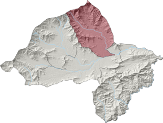
Salarzai Tehsil is an administrative subdivision (tehsil) of Bajaur District in Khyber Pakhtunkhwa Province, Pakistan. Salarzai is the third largest of Bajaur District's seven tehsils.

<span class="mw-page-title-main">Barang Tehsil</span> Pakistani administrative subdivision

Barang Tehsil is an administrative subdivision (tehsil) of Bajaur District in Khyber Pakhtunkhwa, Pakistan. Barang is the sixth largest of Bajaur District's seven tehsils.

<span class="mw-page-title-main">Mamund Tehsil</span> Pakistani administrative subdivision

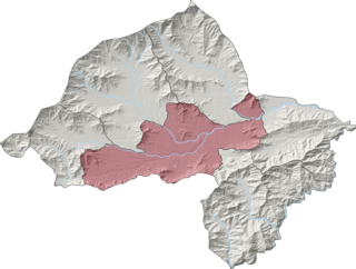
Mamund Tehsil is an administrative subdivision (tehsil) of Bajaur District in Khyber Pakhtunkhwa Province, Pakistan. Mamund is the largest of Bajaur District's seven tehsils.

<span class="mw-page-title-main">Utman Khel Tehsil</span> Pakistani administrative subdivision

Utman Khel Tehsil is an administrative subdivision (tehsil) of Bajaur District in Khyber Pakhtunkhwa Province, Pakistan. Utman Khel is the fifth largest of Bajaur District's seven tehsils.

<span class="mw-page-title-main">Khar Bajaur Tehsil</span> Pakistani administrative subdivision

Khar Bajaur Tehsil, sometimes shortened to Khar Tehsil, is an administrative subdivision (tehsil) of Bajaur District in Khyber Pakhtunkhwa, Pakistan. Khar Bajaur is the second largest of Bajaur District's seven tehsils.

<span class="mw-page-title-main">Nawagai Tehsil</span> Pakistani administrative subdivision

NawagaiTehsil is an administrative subdivision (tehsil) of Bajaur District in Khyber Pakhtunkhwa Province, Pakistan. Nawagai is the fourth largest of Bajaur District's seven tehsils.

Nawagai may refer to:

Sadiq Abad is a town in Khar Bajaur Tehsil, Bajur, Khyber Pakhtunkhwa, Pakistan. The population is 10,060 according to the 2017 census.

On 31 May 2018, with the application of 25th Amendment, Federally Administrated Tribal Areas ceased to exist, and stood merged into neighbouring province of Khyber Pakhtunkhwa.

References

  1. 1 2 "DISTRICT AND TEHSIL LEVEL POPULATION SUMMARY WITH REGION BREAKUP [PDF]" (PDF). Pakistan Bureau of Statistics. 3 January 2018. Archived from the original (PDF) on 26 March 2018. Retrieved 25 March 2018.
  2. Khan, Ismail (31 May 2018). "Mainstreaming Fata with interim governance law". Dawn . Pakistan Herald Publications . Retrieved 2 June 2018.
  3. "AVERAGE HOUSEHOLD SIZE AND GROWTH RATE - FATA TABLE 3 - AREA, POPULATION BY SEX, SEX RATIO, POPULATION DENSITY" (PDF). Pakistan Bureau of Statistics. Archived from the original (PDF) on 8 May 2018. Retrieved 9 May 2018.

34°43′43″N71°12′09″E / 34.7287300°N 71.2026085°E / 34.7287300; 71.2026085