
The Shinwari are an ethnic Pashtun tribe of Afghanistan and Pakistan. Among the greatest poets of the Pashto language in the 20th century was the late Ameer Hamza Shinwari, also known as "Hamza Baba".
The Mohmand or Momand is a prominent tribe of Pashtun people.

Mardan District is a district in the Mardan Division of the Khyber Pakhtunkhwa province of Pakistan. The district is named after Mardan city, which is also the headquarters of the district. The district is famous for its agriculture industry and its archaeological sites, specifically of Takht-i-Bhai, Jamal Garhi and Sawal Dher.
The Tarkani or Tarkalani are a Pashtun tribe mainly settled in Bajaur District, Lower Dir district, Barawal upper dir and in Kabal and Matta tehsil of district Swat Pakistan but originally hailed from the Laghman province of modern-day Afghanistan. They are settled in large parts of Kunar province of Afghanistan and other parts of Afghanistan. In Kunar they stretch all the way up to Naray district of Afghanistan, and are majority in Dangam, Asmar, half of Gehazi Abad, Marah wara, half of Barkani district etc, all districts in Kunar, Afghanistan. they are cousins of the Yousafzai with whom fought battles against Dalzak and Mughals.
The Mamund is a Pashtun clan which is a part of the larger Tarkani tribe. The clan is located principally in the Watelai Valley, Bajaur, but also owns villages on both sides of the Durand Line. Majority of the Mamund Pashtuns live in Mamund Tehsil, Loi Mamund Tehsil and Wara Mamund Tehsil, Bajaur, Khyber Pukhtunkhwa, Pakistan and in Marawara, Asadabad, Shigal, Watapur and Ghazi Abad Districts of Kunar Province in Afghanistan.
The Wur or Wara, meaning small, little or minor, also known as Wur Mamund or Wara Mamund, meaning small, little or minor Mamund or descendants/offspring/children of small, little, minor Mamund, are a Pashtun group. They are a division of the Mamund clan, which is itself part of the larger Tarkani tribe. The Wur are mainly settled in Bajaur Agency in Pakistan, but originally hailed from the Laghman province of Afghanistan.

Hangu District is a district within the Kohat Division of the Khyber Pakhtunkhwa. The district takes its name from the town of Hangu, which is its administrative centre. The name Hangu may also sometimes be applied to the Miranzai Valley which is partly within the district, bordering the Samana Range.
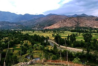
Bajaur District, formerly Bajaur Agency, is a district in the Malakand Division of Khyber Pakhtunkhwa Province, Pakistan. Prior to 2018, Bajaur Agency was the northernmost component of the Federally Administered Tribal Areas (FATA), a semi-autonomous region along the Afghanistan–Pakistan border. In May 2018, FATA was merged into the larger Khyber Pakhtunkhwa Province (KPK) in an attempt to bring stability to the region, redesignating Bajaur Agency to Bajaur District.
Khar, also spelled Khaar, is the headquarters of Bajaur District in Khyber Pakhtunkhwa, Pakistan. Khar was one of the largest towns in the Federally Administered Tribal Areas. It lies near the border with Afghanistan. The headquarters of the Bajaur Scouts are located in the town. A civil colony is located in the town and this place is the court of Bajaur.

Mohmand District is a district in Peshawar Division of Khyber Pakhtunkhwa province in Pakistan. Until 2018, it was an agency of Federally Administered Tribal Areas, with merger of FATA with Khyber Pakhtunkhwa, it became a district. It was created as an agency in 1951. Mohmand is bordered by Bajaur District to the north, Khyber District to the south, Malakand and Charsadda districts to the east and Peshawar district to the southeast.

The Mullagori or Mulagori or Malagori is a Pashtun tribe present in Khyber District, tribal areas in Khyber Pakhtunkhwa, Pakistan. Historically, they are one of the smallest tribes of ethnic Pashtuns. They are considered as a sub-tribe of Momand Pashtun Ghoryakhel confederacy.
The Utmankhel is a Pashtun tribe present in Pakistan, with substantial numbers in Afghanistan. They lie between the Mohmands and the Ranizais of Swat, to the west and south-west of the junction of the Swat and Panjkora rivers. The Utmankhel mostly living in Malakand, Bajaur, Mohmand, Lower Dir, Mardan and Orakzai. The Utmankhel are Pashtuns, part of the Karlani tribal confederacy, who fought against British and Mughals emperors in Pakhtunkhwa. The British regarded the Utmankhel tribesmen as “warlike” peoples and one of the Martial Race. The Utmankhel are a tall, stout and fair race, but their dress and general customs have been assimilated by the neighboring peoples of Bajaur. Utmankhel speak the same dialect of Pashtu called Yousafzai Pashto.
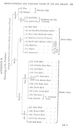
The Kakazai, also known as Loi, Loe, or Loye Mamund, a division of the Mamund clan, are a Pashtun tribe part of the larger Tarkani tribe who are primarily settled in Bajaur Agency, Pakistan, but originally hailed from the Laghman province of Afghanistan. However, it has grown and scattered around to such an extent that it is recognized as tribe of its own.
Salarzai Tehsil is an administrative subdivision (tehsil) of Bajaur District in Khyber Pakhtunkhwa Province, Pakistan. Salarzai is the third largest of Bajaur District's seven tehsils.

Barang Tehsil is an administrative subdivision (tehsil) of Bajaur District in Khyber Pakhtunkhwa, Pakistan. Barang is the sixth largest of Bajaur District's seven tehsils.

Mamund Tehsil is an administrative subdivision (tehsil) of Bajaur District in Khyber Pakhtunkhwa Province, Pakistan. Mamund is the largest of Bajaur District's seven tehsils.

Utman Khel Tehsil is an administrative subdivision (tehsil) of Bajaur District in Khyber Pakhtunkhwa Province, Pakistan. Utman Khel is the fifth largest of Bajaur District's seven tehsils.
Khar Bajaur Tehsil, sometimes shortened to Khar Tehsil, is an administrative subdivision (tehsil) of Bajaur District in Khyber Pakhtunkhwa, Pakistan. Khar Bajaur is the second largest of Bajaur District's seven tehsils.

Bar Chamarkand Tehsil, alternatively written Bar Chamar Kand is an administrative subdivision (tehsil) of Bajaur District in Khyber Pakhtunkhwa Province, Pakistan. Bar Chamarkand is the smallest of Bajaur District's seven tehsils.

