Bannu District is a district in the Bannu Division of the Khyber Pakhtunkhwa province of Pakistan. Its status as a district was formally recorded in 1861 during the British Raj.

Karak District is a district in Kohat Division of Khyber Pakhtunkhwa province in Pakistan. It is situated to the south of Kohat District and on the north side of Bannu and Lakki Marwat districts on the main Indus Highway between Peshawar and Karachi – it is 131 km from the provincial capital Peshawar. It gained a district status in 1982, prior to which it was part of Kohat District.

North Waziristan District is a district of Khyber Pakhtunkhwa province in Pakistan. It is the northern part of Waziristan, a mountainous region of northwest Pakistan, bordering Afghanistan and covering 4,707 square kilometres (1,817 sq mi). The capital city of North Waziristan is Miranshah.

Lakki Marwat or Lakki is the headquarters of Lakki Marwat District in Khyber Pakhtunkhwa province of Pakistan. Lakki Marwat has become one of the fastest growing cities in Khyber Pakhtunkhwa. Lakki Marwat is also the 20th most populous city in the province of Khyber Pakhtunkhwa.

Bannu also called Bana and Bani is a city located on the Kurram River in southern Khyber Pakhtunkhwa, Pakistan. It is the capital of Bannu Division. Bannu's residents are primarily members of the Banuchi tribe and speak Banuchi (Baniswola), a dialect of Pashto which is similar to the distinct Waziristani dialect. The residents regardless of their tribes are commonly called Banusi, Banuchi or Banisi.

Lakki Marwat is a district in the Bannu Division of the Khyber Pakhtunkhwa province of Pakistan. It was created as an administrative district on July 1, 1992, prior to which it was a tehsil of Bannu District.

South Waziristan District was a district in the Dera Ismail Khan Division of the Khyber Pakhtunkhwa province of Pakistan, before splitting into the Lower South Waziristan District and the Upper South Waziristan District on 13 April 2022. It covers around 11,585 km2 (4,473 mi2). Waziristan is located in the southwest of Khyber Pakhtunkhwa. It is situated between two rivers, the Tochi River to the north and the Gomal River to the south. The region was an independent tribal territory from 1893, separated from both Afghanistan and the British-ruled empire in the subcontinent. Raiding the tribal areas was a constant problem for the British, requiring frequent punitive expeditions between 1860 and 1945. Troops of the British Raj coined a name for this region "Hell's Door Knocker" in recognition of the fearsome reputation of the local fighters and inhospitable terrain. The district headquarter of the South Waziristan district is Wanna. South Waziristan is divided into three administrative subdivisions of Ladha, Sarwakai, and Wanna. These three subdivisions are further divided into eight Tehsils: Ladha, Makin, Sararogha, Sarwakai, Tiarza, Wanna, Barmal, and Toi Khula.
Kohat Division is one of the seven divisions in the Khyber Pakhtunkhwa province of Pakistan. It consists of five districts: Hangu, Karak, Kohat, Kurram, and Orakzai. The division borders Bannu Division to the south and west, Peshawar Division to the north and east, the province of Punjab to the east, and Afghanistan to the northwest. CNIC code of Kohat Division is 14.

Mardan Division is one of the seven divisions in the Khyber Pakhtunkhwa province of Pakistan. It consists of two districts: Mardan and Swabi. The division borders Hazara Division, Malakand Division, and Peshawar Division. CNIC code of Mardan Division is 16.
Bannu Division is one of seven divisions in Pakistan's Khyber Pakhtunkhwa province. It consists of three districts: Bannu, Lakki Marwat, and North Waziristan. The division borders Dera Ismail Khan Division to the south and west, Kohat Division to the north and east, and the province of Punjab, Pakistan to its east. CNIC code of Bannu Division is 11.
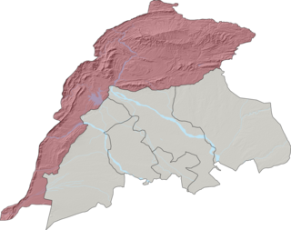
Domel Tehsil, alternatively transliterated as Domail Tehsil, is an administrative subdivision (tehsil) of Bannu District, Bannu Division, Khyber Pakhtunkhwa Province, Pakistan. It is located about 15 km from Bannu on Bannu–Kohat road.
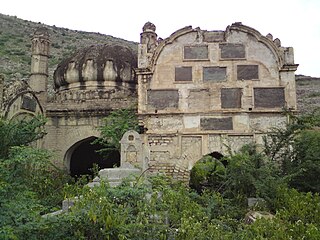
Domel also spelled as Domail is a main town in Domel tehsil of Bannu District in Khyber Pakhtunkhwa province of Pakistan. It is also union council of Bannu District in Khyber-Pakhtunkhwa. Domel is inhabited mostly by Ahmadzai Wazir tribe of Pashtuns. Majority of the population follow Islam as their main religion.
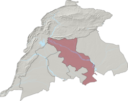
Wazir Tehsil is an administrative subdivision (tehsil) of Bannu District, Bannu Division, Khyber Pakhtunkhwa Province, Pakistan. The total population, according to the 1998 census, was 19,600, 98.1% of which have Pashto as a first language, and the remaining 1.9% speak Punjabi.

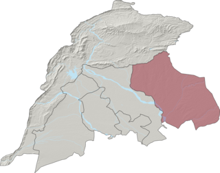
Bettani Tehsil is an administrative subdivision (tehsil) of Lakki Marwat District in Khyber Pakhtunkhwa province of Pakistan. This subdivision shares its boundary on the north with Bannu Subdivision, on the west with Jandola Tehsil, to the west with North and South Waziristan and to the northeast with the district of Lakki Marwat. Its total area is 132 square kilometers.
Jandola Tehsil is an administrative subdivision (tehsil) of Tank District in Khyber Pakhtunkhwa province of Pakistan. The subdivision borders South Waziristan to the north, south and west and Lakki Marwat District to the north-east.
Lachi is one of the two tehsils in the Kohat District of Khyber Pakhtunkhwa province in Pakistan, located south of the district capital Kohat. It houses about 100,000 inhabitants, living in 1,161 square kilometres (448 sq mi). The tehsil is subdivided into nine union councils. About 40% of the working population is employed outside the tehsil.It is a rural area where most households' livelihood depends on remittances and subsistence farming. Education is provided through several private and government high schools, as well as a government degree college affiliated with Kohat University.
Sarai Naurang is a tehsil located in Lakki Marwat District, Khyber Pakhtunkhwa, Pakistan. The population is 296,908 according to the 2017 census. It is a mostly rural area, but it does contain one urban area, the town of Naurang, which has a population of 29,955. Naurang is the second-largest city in Lakki Marwat District and the third-largest in Bannu Division.

Hinduism is a minority religion in the Khyber Pakhtunkhwa province followed by 0.02% of the population of the province as per 2023 Census.