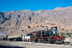
Khyber District is a district in the Peshawar Division of the Khyber Pakhtunkhwa province of Pakistan. Until 2018, it was an agency of the erstwhile Federally Administered Tribal Areas. With the merger of FATA with Khyber Pakhtunkhwa in 2018, it became a district. It ranges from the Tirah valley down to Peshawar. It borders Nangarhar Province to the west, Orakzai District to the south, Kurram District to southwest, Peshawar to the east and Mohmand District to the north.

Bara Tehsil is a subdivision located in Khyber District, Khyber Pakhtunkhwa, Pakistan.
Alpuri is a tehsil located in Shangla District, Khyber Pakhtunkhwa, Pakistan. The population is 506,718 according to the 2017 census.
Lal Qilla is an administrative subdivision (Tehsil) of Lower Dir District in the Khyber Pakhtunkhwa province of Pakistan. The other tehsils of the district include:
- Adenzai Tehsil
- Balambat Tehsil
- Khall Tehsil
- Munda Tehsil
- Samar Bagh Tehsil
- Timergara Tehsil
Samar Bagh is an administrative subdivision (Tehsil) of Lower Dir District in the Khyber Pakhtunkhwa province of Pakistan. The other tehsils of the district include:
- Adenzai Tehsil
- Balambat Tehsil
- Khall Tehsil
- Lal Qilla Tehsil
- Munda Tehsil`
- Timergara Tehsil

Timergara is an administrative subdivision (Tehsil) of Lower Dir District in the Khyber Pakhtunkhwa province of Pakistan. The other tehsils of the district include:
- Adenzai Tehsil
- Balambat Tehsil
- Khal Tehsil
- Lal Qilla Tehsil
- Munda Tehsil
- Samar Bagh Tehsil
Adenzai is a tehsil located in Lower Dir District, Khyber Pakhtunkhwa, Pakistan. The tehsil includes the town of Chakdara.The name Adenzai is derived from the Adenzai clan of Yousafzai Pashtoon tribe. It is listed among:
- Adenzai Tehsil
- Balambat Tehsil
- Khall Tehsil
- Lal Qilla Tehsil
- Munda Tehsil
- Samar Bagh Tehsil
- Timergara Tehsil
Matta is an administrative subdivision (Tehsil) of Swat District in the Khyber Pakhtunkhwa province of Pakistan.
Barikot is an administrative subdivision (tehsil) of Swat District in the Khyber Pakhtunkhwa province of Pakistan.

Charbagh is an administrative subdivision (tehsil) of Swat District in the Khyber Pakhtunkhwa province of Pakistan.

The Valley of Peshawar, or Peshawar Basin, historically known as the Gandhara Valley, is a broad area situated in the central part of the Khyber Pakhtunkhwa province of Pakistan. The valley is 7,176 km2 (2,771 sq mi) in area, and is traversed by the Kabul River. It has a mean elevation of 345 metres (1,132 ft). The valley takes its name from the city of Peshawar, which is situated at the western part of the valley close to Warsak Dam. To the west of the valley lies the Khyber Pass. The five most populous cities in the valley are Peshawar, Mardan, Swabi, Charsadda, and Nowshera.
Judba is a tehsil located in Torghar District, Khyber Pakhtunkhwa, Pakistan. The population is 96,757 according to the 2017 census.
Hangu is a tehsil located in Hangu District, Khyber Pakhtunkhwa, Pakistan. The population is 270,295 according to the 2017 census.
Thall is a tehsil located in Hangu District, Khyber Pakhtunkhwa, Pakistan. The population is 248,503 according to the 2017 census.
Banda Daud Shash is Headquarter of BD Shah Tehsil a tehsil located in Karak District, Khyber Pakhtunkhwa, Pakistan. The population of Tehsil is 155,642 according to the 2017 census.
Karak is a tehsil located in Karak District, Khyber Pakhtunkhwa, Pakistan. The population is 155,642 according to the 2017 census.
Daggar is a tehsil located in Buner District, Khyber Pakhtunkhwa, Pakistan. The population is 355,692 according to the 2017 census.
Behrain is a tehsil located in Swat District, Khyber Pakhtunkhwa, Pakistan. The population is 61,787, according to the 2017 census.
Sharingal is a tehsil located in Upper Dir District, Khyber Pakhtunkhwa, Pakistan. The population is 185,037 according to the 2017 census.
Nowshera is a tehsil located in Nowshera District, Khyber Pakhtunkhwa, Pakistan. The population is 727,749 according to the 2017 census.


