
Mardan District is a district in the Mardan Division of the Khyber Pakhtunkhwa province of Pakistan. The district is named after Mardan city, which is also the headquarters of the district. The district is famous for its agriculture industry and its archaeological sites, specifically of Takht-i-Bhai, Jamal Garhi and Sawal Dher.

Peshawar District is a district in the Peshawar Division of the Khyber Pakhtunkhwa province of Pakistan. It is located about 160 km west of the Pakistan's capital Islamabad. The district headquarter is the city of Peshawar, which is also the capital of Khyber Paktunkhwa.
The Tarkani or Tarkalani are a Pashtun tribe mainly settled in Bajaur District, Lower Dir district, Barawal upper dir and in Kabal and Matta tehsil of district Swat Pakistan but originally hailed from the Laghman province of modern-day Afghanistan. They are settled in large parts of Kunar province of Afghanistan and other parts of Afghanistan. In Kunar they stretch all the way up to Naray district of Afghanistan, and are majority in Dangam, Asmar, half of Gehazi Abad, Marah wara, half of Barkani district etc, all districts in Kunar, Afghanistan.

Nowshera is the capital city of Nowshera District in the Khyber Pakhtunkhwa province of Pakistan. It is the 78th largest city in Pakistan and ninth largest city in the province of Khyber Pakhtunkhwa.
The Mamund is a Pashtun clan which is a part of the larger Tarkani tribe. The clan is located principally in the Watelai valley, Bajaur, but also owns villages on both sides of the Durand Line. Majority of the Mamund Pashtuns live in Mamund Tehsil, Loi Mamund Tehsil and Wara Mamund Tehsil, Bajaur, Khyber Pukhtunkhwa, Pakistan and in Marawara, Asadabad, Shigal, Watapur and Ghazi Abad Districts of Kunar Province in Afghanistan.

Dir is a region in northwestern Pakistan in the Khyber Pakhtunkhwa, in the foothills of the Himalayas. Before the independence of Pakistan, Dir was a princely state, and it remained so until 1969 when it was abolished by a presidential declaration, and the Dir District was created the following year. The area covers 5,280 square kilometres. In 1996 Dir district was officially divided into Lower Dir District and Upper Dir District.

Hangu District is a district within the Kohat Division of the Khyber Pakhtunkhwa. The district takes its name from the town of Hangu, which is its administrative centre. The name Hangu may also sometimes be applied to the Miranzai Valley which is partly within the district, bordering the Samana Range.
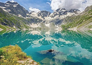
Lower Dir District is a district in the Khyber Pakhtunkhwa province of Pakistan. Timergara city is the district's headquarter. This district was formed in 1996, when Dir District was divided into Upper Dir and Lower Dir districts. On 22 January 2023, both Lower Dir and Upper Dir districts were further bifurcated to create a new Central Dir District. Lower Dir contains a lot of valleys and mountains. "tajoka sar" was a mountain peak in Dir and the highest mountain peak in Lower Dir Kpk, Pakistan. The hight of Tajoka sar was 3308m (10853ft) from sea level. It is Located in BinShahi Valley, Lower Dir kpk, Pakistan.

Upper Dir District is a district located in the Malakand Division of Khyber Pakhtunkhwa province of Pakistan. The city of Dir is its district headquarter. Geographically, it is located in the northern part of Pakistan. It borders with the Chitral district on the north, Afghanistan on the northwest, the Swat district on the east, and the Lower Dir district on the south. It shares 40 to 50 kilometers border with Afghanistan.

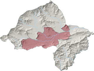
Bajaur District, formerly Bajaur Agency, is a district in the Malakand Division of Khyber Pakhtunkhwa Province, Pakistan. Prior to 2018, Bajaur Agency was the northernmost component of the Federally Administered Tribal Areas (FATA), a semi-autonomous region along the Afghanistan–Pakistan border. In May 2018, FATA was merged into the larger Khyber Pakhtunkhwa Province (KPK) in an attempt to bring stability to the region, redesignating Bajaur Agency to Bajaur District.
Khar, also spelled Khaar, is the headquarters of Bajaur District in Khyber Pakhtunkhwa, Pakistan. Khar was one of the largest towns in the Federally Administered Tribal Areas. It lies near the border with Afghanistan. The headquarters of the Bajaur Scouts are located in the town. A civil colony is located in the town and this place is the court of Bajaur.

Mohmand District is a district in Peshawar Division of Khyber Pakhtunkhwa province in Pakistan. Until 2018, it was an agency of Federally Administered Tribal Areas, with merger of FATA with Khyber Pakhtunkhwa, it became a district. It was created as an agency in 1951. Mohmand is bordered by Bajaur District to the north, Khyber District to the south, Malakand and Charsadda districts to the east and Peshawar district to the southeast.

Chamkani is a neighborhood of Peshawar in Khyber Pakhtunkhwa, Pakistan. It is named after the Chamkani tribe of Pashtuns, who are based in the Tsamkani District of Paktia Province, Afghanistan, as well as in Kurram District, Khyber Pakhtunkhwa, Pakistan.

Barang Tehsil is an administrative subdivision (tehsil) of Bajaur District in Khyber Pakhtunkhwa, Pakistan. Barang is the sixth largest of Bajaur District's seven tehsils.

Mamund Tehsil is an administrative subdivision (tehsil) of Bajaur District in Khyber Pakhtunkhwa Province, Pakistan. Mamund is the largest of Bajaur District's seven tehsils.

Utman Khel Tehsil is an administrative subdivision (tehsil) of Bajaur District in Khyber Pakhtunkhwa Province, Pakistan. Utman Khel is the fifth largest of Bajaur District's seven tehsils.
Khar Bajaur Tehsil, sometimes shortened to Khar Tehsil, is an administrative subdivision (tehsil) of Bajaur District in Khyber Pakhtunkhwa, Pakistan. Khar Bajaur is the second largest of Bajaur District's seven tehsils.

NawagaiTehsil is an administrative subdivision (tehsil) of Bajaur District in Khyber Pakhtunkhwa Province, Pakistan. Nawagai is the fourth largest of Bajaur District's seven tehsils.

Bar Chamarkand Tehsil, alternatively written Bar Chamar Kand is an administrative subdivision (tehsil) of Bajaur District in Khyber Pakhtunkhwa Province, Pakistan. Bar Chamarkand is the smallest of Bajaur District's seven tehsils.

Upper Chitral District (Khowar: توری ݯھیترارو ضلع)(Pashto: پورتنۍ چترال ولسوالۍ) is a district in the province of Khyber Pakhtunkhwa, Pakistan. Chitral River flows throughout the district. Upper Chitral District along with the Lower Chitral District were part of the erstwhile Chitral District which was the largest district in the Khyber-Pakhtunkhwa province of Pakistan, covering an area of 14,850 km2. Likewise, it served as the Chitral princely state that encompassed the region until its direct incorporation into the Khyber Pakhtunkhwa province of Pakistan in 14 August 1947. Upper Chitral District and Lower Chitral District were bifurcated from the erstwhile Chitral District in November, 2018.

