
North Waziristan District is a district of Khyber Pakhtunkhwa province in Pakistan. It is the northern part of Waziristan, a mountainous region of northwest Pakistan, bordering Afghanistan and covering 4,707 square kilometres (1,817 sq mi). The capital city of North Waziristan is Miranshah.

Orakzai District is a district in the Kohat Division of the Khyber Pakhtunkhwa province of Pakistan. Before 1973, it was part of FR Kohat. Up until 2018, it was an agency within the erstwhile Federally Administered Tribal Areas. However, with the merger of the FATA with Khyber Pakhtunkhwa, it attained the status of a district.

Khyber District is a district in the Peshawar Division of the Khyber Pakhtunkhwa province of Pakistan. Until 2018, it was an agency of the erstwhile Federally Administered Tribal Areas. With the merger of FATA with Khyber Pakhtunkhwa in 2018, it became a district. It ranges from the Tirah valley down to Peshawar. It borders Nangarhar Province to the west, Orakzai District to the south, Kurram District to southwest, Peshawar to the east and Mohmand District to the north.
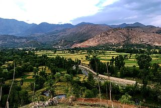
Bajaur District, formerly Bajaur Agency, is a district in the Malakand Division of Khyber Pakhtunkhwa Province, Pakistan. Prior to 2018, Bajaur Agency was the northernmost component of the Federally Administered Tribal Areas (FATA), a semi-autonomous region along the Afghanistan–Pakistan border. In May 2018, FATA was merged into the larger Khyber Pakhtunkhwa Province (KPK) in an attempt to bring stability to the region, redesignating Bajaur Agency to Bajaur District.

Mohmand District is a district in Peshawar Division of Khyber Pakhtunkhwa province in Pakistan. Until 2018, it was an agency of Federally Administered Tribal Areas, with merger of FATA with Khyber Pakhtunkhwa, it became a district. It was created as an agency in 1951. Mohmand is bordered by Bajaur District to the north, Khyber District to the south, Malakand and Charsadda districts to the east and Peshawar district to the southeast.
The Utmankhel is a Pashtun tribe present in Pakistan, with substantial numbers in Afghanistan. They lie between the Mohmands and the Ranizais of Swat, to the west and south-west of the junction of the Swat and Panjkora rivers. The Utmankhel mostly living in Malakand, Bajaur, Mohmand, Lower Dir, Mardan and Orakzai. The Utmankhel are Pashtuns, part of the Karlani tribal confederacy, who fought against British and Mughals emperors in Pakhtunkhwa. The British regarded the Utmankhel tribesmen as “warlike” peoples and one of the Martial Race. The Utmankhel are a tall, stout and fair race, but their dress and general customs have been assimilated by the neighboring peoples of Bajaur. Utmankhel speak the same dialect of Pashtu called Yousafzai Pashto.
Charsadda Tehsil is a tehsil located in Charsadda District, Khyber Pakhtunkhwa, Pakistan.
The Federally Administered Tribal Areas, commonly known as FATA, was a semi-autonomous tribal region in north-western Pakistan that existed from 1947 until being merged with the neighbouring province of Khyber Pakhtunkhwa in 2018 through the Twenty-fifth amendment to the constitution of Pakistan. It consisted of seven tribal agencies (districts) and six frontier regions, and were directly governed by the federal government through a special set of laws called the Frontier Crimes Regulations.

Hassan Khel Tehsil is an administrative subdivision (tehsil) of Peshawar District in Khyber Pakhtunkhwa province of Pakistan. This subdivision borders Nowshera District to the east and Kohat Subdivision to the south.

NA-40 is a constituency for the National Assembly of Pakistan comprising Utman Khel Tehsil, Barang Tehsil, Khar Bajaur Tehsil, Bar Chamarkand Tehsil, Nawagai Tehsil, and Mandal and Shamozai sections of Salarzai Tehsil in Bajaur District.

FATA University is a public sector university situated in Akhorwal, Tribal Sub-Division Darra Adam Khel, Kohat, Khyber Pakhtunkhwa, Pakistan. The university is run by the Higher Education Department, Government of Khyber Pakhtunkhwa.
Salarzai Tehsil is an administrative subdivision (tehsil) of Bajaur District in Khyber Pakhtunkhwa Province, Pakistan. Salarzai is the third largest of Bajaur District's seven tehsils.

Mamund Tehsil is an administrative subdivision (tehsil) of Bajaur District in Khyber Pakhtunkhwa Province, Pakistan. Mamund is the largest of Bajaur District's seven tehsils.

Utman Khel Tehsil is an administrative subdivision (tehsil) of Bajaur District in Khyber Pakhtunkhwa Province, Pakistan. Utman Khel is the fifth largest of Bajaur District's seven tehsils.
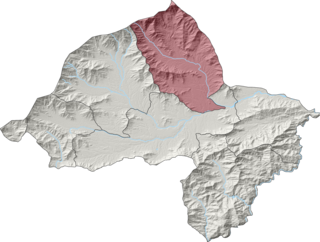
Khar Bajaur Tehsil, sometimes shortened to Khar Tehsil, is an administrative subdivision (tehsil) of Bajaur District in Khyber Pakhtunkhwa, Pakistan. Khar Bajaur is the second largest of Bajaur District's seven tehsils.

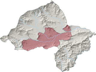
NawagaiTehsil is an administrative subdivision (tehsil) of Bajaur District in Khyber Pakhtunkhwa Province, Pakistan. Nawagai is the fourth largest of Bajaur District's seven tehsils.

Bar Chamarkand Tehsil, alternatively written Bar Chamar Kand is an administrative subdivision (tehsil) of Bajaur District in Khyber Pakhtunkhwa Province, Pakistan. Bar Chamarkand is the smallest of Bajaur District's seven tehsils.
On 31 May 2018, with the application of 25th Amendment, Federally Administrated Tribal Areas ceased to exist, and stood merged into neighbouring province of Khyber Pakhtunkhwa.

