The Tarkani or Tarkalani are a Pashtun tribe mainly settled in Bajaur District, Lower Dir district, Barawal upper dir and in Kabal and Matta tehsil of district Swat Pakistan but originally hailed from the Laghman province of modern-day Afghanistan. They are settled in large parts of Kunar province of Afghanistan and other parts of Afghanistan. In Kunar they stretch all the way up to Naray district of Afghanistan, and are majority in Dangam, Asmar, half of Gehazi Abad, Marah wara, half of Barkani district etc, all districts in Kunar, Afghanistan. they are cousins of the Yousafzai with whom fought battles against Dalzak and Mughals.
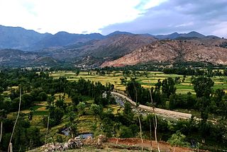
The Mamund is a Pashtun clan which is a part of the larger Tarkani tribe. The clan is located principally in the Watelai Valley, Bajaur, but also owns villages on both sides of the Durand Line. Majority of the Mamund Pashtuns live in Mamund Tehsil, Loi Mamund Tehsil and Wara Mamund Tehsil, Bajaur, Khyber Pukhtunkhwa, Pakistan and in Marawara, Asadabad, Shigal, Watapur and Ghazi Abad Districts of Kunar Province in Afghanistan.
The Wur or Wara, meaning small, little or minor, also known as Wur Mamund or Wara Mamund, meaning small, little or minor Mamund or descendants/offspring/children of small, little, minor Mamund, are a Pashtun group. They are a division of the Mamund clan, which is itself part of the larger Tarkani tribe. The Wur are mainly settled in Bajaur Agency in Pakistan, but originally hailed from the Laghman province of Afghanistan.
Bajaur District, formerly Bajaur Agency, is a district in the Malakand Division of Khyber Pakhtunkhwa Province, Pakistan. Prior to 2018, Bajaur Agency was the northernmost component of the Federally Administered Tribal Areas (FATA), a semi-autonomous region along the Afghanistan–Pakistan border. In May 2018, FATA was merged into the larger Khyber Pakhtunkhwa Province (KPK) in an attempt to bring stability to the region, redesignating Bajaur Agency to Bajaur District.

Mohmand District is a district in Peshawar Division of Khyber Pakhtunkhwa province in Pakistan. Until 2018, it was an agency of Federally Administered Tribal Areas, with merger of FATA with Khyber Pakhtunkhwa, it became a district. It was created as an agency in 1951. Mohmand is bordered by Bajaur District to the north, Khyber District to the south, Malakand and Charsadda districts to the east and Peshawar district to the southeast.

The Battle of Bajaur, also known as Operation Sherdil, was a military campaign in the Bajaur region of Pakistan. It was conducted on 7 August 2008 by the Frontier Corps and Infantry Brigade of Pakistan army. The operation was primarily launched to end the political movement of the Tehrik-e-Taliban Pakistan. Bajaur area was administered by Tehrik-e-Taliban Pakistan until 2007, and it remained Al-Qaeda's central command and control for carrying out activities in Northeast Afghanistan and Kunar province. Recent reports indicate that ongoing conflict has newly displaced an estimate of 7,000 people between 3 and 4 March in Nurgal district.
The Federally Administered Tribal Areas, commonly known as FATA, was a semi-autonomous tribal region in north-western Pakistan that existed from 1947 until being merged with the neighbouring province of Khyber Pakhtunkhwa in 2018 through the Twenty-fifth amendment to the constitution of Pakistan. It consisted of seven tribal agencies (districts) and six frontier regions, and were directly governed by the federal government through a special set of laws called the Frontier Crimes Regulations.
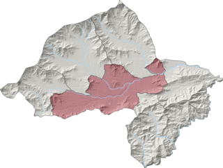
Salarzai Tehsil is an administrative subdivision (tehsil) of Bajaur District in Khyber Pakhtunkhwa Province, Pakistan. Salarzai is the third largest of Bajaur District's seven tehsils.

Barang Tehsil is an administrative subdivision (tehsil) of Bajaur District in Khyber Pakhtunkhwa, Pakistan. Barang is the sixth largest of Bajaur District's seven tehsils.

Utman Khel Tehsil is an administrative subdivision (tehsil) of Bajaur District in Khyber Pakhtunkhwa Province, Pakistan. Utman Khel is the fifth largest of Bajaur District's seven tehsils.
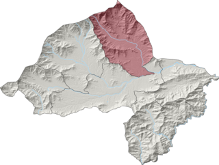
Khar Bajaur Tehsil, sometimes shortened to Khar Tehsil, is an administrative subdivision (tehsil) of Bajaur District in Khyber Pakhtunkhwa, Pakistan. Khar Bajaur is the second largest of Bajaur District's seven tehsils.

NawagaiTehsil is an administrative subdivision (tehsil) of Bajaur District in Khyber Pakhtunkhwa Province, Pakistan. Nawagai is the fourth largest of Bajaur District's seven tehsils.
Kitkot or Katkot is a village located in Mamund Tehsil, Bajaur District, Khyber Pakhtunkhwa, Pakistan. The population is 7,398 according to the 2017 census.
Pashat is the main town in Salarzai Tehsil, Bajaur District, in the Khyber Pakhtunkhwa province of Pakistan. The population is 5,111 according to the 2017 census.
Batwar is an area of Salarzai Tehsil, in Bajaur District, Khyber Pakhtunkhwa province, Pakistan. The population is 5,267 according to the 2017 census.
Begal is an area within the Salarzai Tehsil of the Bajaur District in Khyber Pakhtunkhwa, Pakistan. The population was 1,314 in the 2017 national census.

Bar Chamarkand Tehsil, alternatively written Bar Chamar Kand is an administrative subdivision (tehsil) of Bajaur District in Khyber Pakhtunkhwa Province, Pakistan. Bar Chamarkand is the smallest of Bajaur District's seven tehsils.
On 31 May 2018, with the application of 25th Amendment, Federally Administrated Tribal Areas ceased to exist, and stood merged into neighbouring province of Khyber Pakhtunkhwa.

