Sharingal Tehsil

Last updated
Sharingal Tehsil
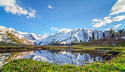
Jahaz Banda Meadows - 3,100 m (Kumrat Valley).jpg
Jahaz Banda meadows in Kumrat Valley, Dir Kohistan
Country Flag of Pakistan.svg Pakistan
Region PK-NWFP.svg  Khyber Pakhtunkhwa
District Upper Dir
Government
  ChairmanShah Wali Khan (PPP)
Area
[1]
  Total1,140 km2 (440 sq mi)
Population
 (2023) [2]
  Total210,356
Time zone UTC+5 (PST)
  Summer (DST) UTC+6 (PDT)

Sharingal, also known as Dir Kohistan, [3] is a tehsil located in Upper Dir District, Khyber Pakhtunkhwa, Pakistan. Forming westernmost portion of the larger Kohistan region, the population of Sharingal tehsil is 210,356 according to the 2023 census. [2]

See also

Related Research Articles

<span class="mw-page-title-main">Dir District</span> Place in Pakistan

Dir is a region in northwestern Pakistan in the Khyber Pakhtunkhwa, in the foothills of the Himalayas. Before the independence of Pakistan, Dir was a princely state, and it remained so until 1969 when it was abolished by a presidential declaration, and the Dir District was created the following year. The area covers 5,280 square kilometres. In 1996 Dir district was officially divided into Lower Dir District and Upper Dir District.

<span class="mw-page-title-main">Malakand Division</span> Administrative division of Khyber Pakhtunkhwa, Pakistan

Malakand Division is an administrative division of Khyber Pakhtunkhwa province of Pakistan. Malakand is the Fisrt largest Division by Population and Mingora is its capital which is 3rd largest city in Privance. CNIC code of Malakand Division is 15.

<span class="mw-page-title-main">Lower Dir District</span> District of Khyber Pakhtunkhwa in Pakistan

Lower Dir District is a district in the Khyber Pakhtunkhwa province of Pakistan. Timergara is the district's headquarters and largest city. The Lower Dir district was formed in 1996, when Dir District was divided into Upper Dir and Lower Dir districts. On 22 January 2023, both Lower Dir and Upper Dir districts were further bifurcated to create a new Central Dir District. Lower Dir is famous for its beautiful snow-capped mountains, valleys, and pleasant weather. The primary industry in Lower Dir is tourism, which is now rapidly growing.

<span class="mw-page-title-main">Upper Dir District</span> District in Khyber Pakhtunkhwa, Pakistan

Upper Dir District is a district located in the Malakand Division of Khyber Pakhtunkhwa province of Pakistan. The city of Dir is its district headquarter. Geographically, it is located in the northern part of Pakistan. It borders with the Chitral district on the north, Afghanistan on the northwest, the Swat district on the east, and the Lower Dir district on the south. It shares 40 to 50 kilometers border with Afghanistan.

<span class="mw-page-title-main">Palas Valley</span> Place in Khyber Pakhtunkhwa, Pakistan

Palas is a tehsil and valley in Kolai-Palas District, Khyber Pakhtunkhwa the province of Pakistan.

Lal Qilla is an administrative subdivision (Tehsil) of Lower Dir District in the Khyber Pakhtunkhwa province of Pakistan. The other tehsils of the district include:

  1. Adenzai Tehsil
  2. Balambat Tehsil
  3. Khall Tehsil
  4. Munda Tehsil
  5. Samar Bagh Tehsil
  6. Timergara Tehsil

Samar Bagh is an administrative subdivision (Tehsil) of Lower Dir District in the Khyber Pakhtunkhwa province of Pakistan. The other tehsils of the district include:

  1. Adenzai Tehsil
  2. Balambat Tehsil
  3. Khall Tehsil
  4. Lal Qilla Tehsil
  5. Munda Tehsil`
  6. Timergara Tehsil
<span class="mw-page-title-main">Timergara Tehsil</span> Tehsil in Khyber Pakhtunkhwa, Pakistan

Timergara is an administrative subdivision (Tehsil) of Lower Dir District in the Khyber Pakhtunkhwa province of Pakistan. The other tehsils of the district include:

  1. Adenzai Tehsil
  2. Balambat Tehsil
  3. Khal Tehsil
  4. Lal Qilla Tehsil
  5. Munda Tehsil
  6. Samar Bagh Tehsil

Adenzai is a tehsil located in Lower Dir District, Khyber Pakhtunkhwa, Pakistan. The tehsil includes the town of Chakdara.The name Adenzai is derived from the Adenzai clan of Yousafzai Pashtoon tribe. It is listed among:

  1. Adenzai Tehsil
  2. Balambat Tehsil
  3. Khall Tehsil
  4. Lal Qilla Tehsil
  5. Munda Tehsil
  6. Samar Bagh Tehsil
  7. Timergara Tehsil

Sheringal is an administrative unit, known as Union Council, of Upper Dir District in the Khyber Pakhtunkhwa province of Pakistan.

<span class="mw-page-title-main">Pattan Tehsil</span> Place in Khyber Pakhtunkhwa, Pakistan

Pattan is the capital of Lower Kohistan District in the Khyber Pakhtunkhwa province of Pakistan.

Darmai is an administrative unit, known as Union council, of Swat District in the Khyber Pakhtunkhwa province of Pakistan. District Swat has 9 Tehsils, including Khwazakhela, Kabal, Madyan, Barikot, Mingora, Charbagh, and Kalam. Each Tehsil comprises a number of union councils. There are 65 union councils in district Swat, which include 56 rural and 9 urban ones.

Sakhra is an administrative unit, known as union council, of Swat District in the Khyber Pakhtunkhwa province of Pakistan. District Swat has 9 Tehsils, including Khwazakhela, Kabal, Madyan, Barikot, Mingora, Charbagh, and Kalam. Each Tehsil comprises a number of union councils. The 65 union councils of district Swat include 56 rural and 9 urban ones.

Biha is an administrative unit, known as Union council, of Swat District in the Khyber Pakhtunkhwa province of Pakistan. District Swat has 7 Tehsils i.e. Khwazakhela, Kabal, Bahrain, Charbagh, Barikot, Babuzai, and Matta. Each Tehsill comprises certain numbers of union councils. There are 65 union councils in district Swat, 56 rural and 09 urban.

<span class="mw-page-title-main">Lower Kohistan District</span> District of Khyber Pakhtunkhwa in Pakistan

Lower Kohistan District is a district in the Hazara Division of the Khyber Pakhtunkhwa province of Pakistan. Pattan is the district headquarters of Lower Kohistan. Kohistani people form majority in the district.

<span class="mw-page-title-main">Upper Kohistan District</span> District of Khyber Pakhtunkhwa in Pakistan

Upper Kohistan District is a district in the Hazara Division of the Khyber Pakhtunkhwa province of Pakistan.

<span class="mw-page-title-main">Kolai-Palas Kohistan District</span> District of Khyber Pakhtunkhwa in Pakistan

Kolai-Palas Kohistan District is a district in the Hazara Division of the Khyber Pakhtunkhwa province of Pakistan. It was a sub-division of the Kohistan district within the Hazara division till it attained the status of a separate district in 2017.

Kandia is a tehsil located in the Upper Kohistan District of Khyber Pakhtunkhwa, Pakistan. It consists of five union councils: Karang, Thoti, Kareen, Jashoi and Gabrial. The population is 84,055 according to the 2017 census.

<span class="mw-page-title-main">Behrain Tehsil</span> Tehsil in Khyber Pakhtunkhwa, Pakistan

Behrain, also known as Swat Kohistan, is a tehsil located in Swat District, Khyber Pakhtunkhwa, Pakistan. The population is 270,620, according to the 2023 census. Behrain has an area of 2,899 km2, and is part of the larger Kohistan region. It is known for alpine valleys such as Kalam and is home to a number of Indigenous Indo-Aryan peoples, including Gujar, Kho and Gawri.

References

  1. "Pakistan: Khyber Pakhtunkhwa (Districts and Subdistricts) - Population Statistics, Charts and Map". City Population. Retrieved 4 September 2024.
  2. 1 2 "7th Population and Housing Census - Detailed Results: Table 11" (PDF). Pakistan Bureau of Statistics .
  3. Sustainable Development: Bridging the Research/policy Gaps in Southern Contexts. SDPI. 2005. p. 15. ISBN   978-0-19-597978-7.

35°17′N72°00′E / 35.283°N 72.000°E / 35.283; 72.000