The Tarkani or Tarkalani are a Pashtun tribe mainly settled in Bajaur District, Lower Dir district, Barawal upper dir and in Kabal and Matta tehsil of district Swat Pakistan but originally hailed from the Laghman province of modern-day Afghanistan. They are settled in large parts of Kunar province of Afghanistan and other parts of Afghanistan. In Kunar they stretch all the way up to Naray district of Afghanistan, and are majority in Dangam, Asmar, half of Gehazi Abad, Marah wara, half of Barkani district etc, all districts in Kunar, Afghanistan. they are cousins of the Yousafzai with whom fought battles against Dalzak and Mughals.

The Provincially Administered Tribal Area (PATA) was the former administrative subdivision of Pakistan designated in the Article 246(b) of the Constitution of Pakistan. No Act of Provincial Assembly can be applied to PATA whereas the Governor of the respective province has a mandate parallel to the authority President of Pakistan has over Federally Administered Tribal Areas. In 2018, a Twenty-fifth Amendment to the Constitution of Pakistan merged PATA, as well as FATA into full control of the Khyber-Paktunkhwa government, thus the PATA designation has no legal standing in the future of Khyber-Paktunkhwa.

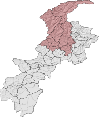
Dir is a region in northwestern Pakistan in the Khyber Pakhtunkhwa, in the foothills of the Himalayas. Before the independence of Pakistan, Dir was a princely state, and it remained so until 1969 when it was abolished by a presidential declaration, and the Dir District was created the following year. The area covers 5,280 square kilometres. In 1996 Dir district was officially divided into Lower Dir District and Upper Dir District.

The Panjkora River is a river in the Khyber Pakhtunkhwa province in north-west Pakistan. The river runs through the mountainous northern part of the province, and forms the Kumrat Valley. It passes from Dir, Timergara, and joins with Swat River at Chakdara. It is generally characterized by steep slopes on either side of the riverbank covered in thick forests. The river has a large catchment area, making the river susceptible to significant flooding – most notably during the 2010 floods that occurred throughout much of Pakistan. It was named after Panjkora clan, a sub-clan in Mamyali section of Swati tribe which inhabited this region during 12 and 16 centuries and currently living in Hazara Division.

Malakand Division is an administrative division of Khyber Pakhtunkhwa province of Pakistan. Malakand is the second-largest division by population while Mingora, its capital, is the third largest city in the province. CNIC code of Malakand Division is 15.
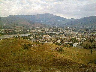
Dir is a city in the Upper Dir District of the Khyber-Pakhtunkhwa province of Pakistan. It is sometimes known as Dir Khas to distinguish it from the district's name, Dir. It lies along the Dir River, a tributary of the Panjkora River. It is at the base of the Lowarai Pass, the main road to Chitral.

Lower Dir District is a district in the Khyber Pakhtunkhwa province of Pakistan. Timergara is the district's headquarters and largest city. The Lower Dir district was formed in 1996, when Dir District was divided into Upper Dir and Lower Dir districts. On 22 January 2023, both Lower Dir and Upper Dir districts were further bifurcated to create a new Central Dir District. Lower Dir is famous for its beautiful snow-capped mountains, valleys, and pleasant weather. The primary industry in Lower Dir is tourism, which is now rapidly growing.

Upper Dir District is a district located in the Malakand Division of Khyber Pakhtunkhwa province of Pakistan. The city of Dir is its district headquarter. Geographically, it is located in the northern part of Pakistan. It borders with the Chitral district on the north, Afghanistan on the northwest, the Swat district on the east, and the Lower Dir district on the south. It shares 40 to 50 kilometers border with Afghanistan.

NA-5 Upper Dir is a constituency for the National Assembly of Pakistan. It comprises the whole district of Upper Dir. The area was formerly part of NA-33 constituency from 1977 to 2018. That constituency also included parts of the district of Lower Dir. The constituency for Upper Dir was named NA-5.

NA-6 Lower Dir-I is a constituency for the National Assembly of Pakistan. The area was formerly part of NA-34 constituency from 1977 to 2018. The delimitation in 2018 split Lower Dir into two separate constituencies, NA-6 and NA-7.
Chukiatan, also known as Chutiatan or Chukyatan, is a small town 9 km from Dir, in Khyber Pakhtunkhwa in Pakistan. It is the main route for Barawal Bandi, and Kohistan (Kumrat). The rivers Dir, Panjkora and Barawal meet each other there. Chukiatan has several picnic and fishing spots on the riverbanks, with people from all over Lower and Upper Dir coming for the fishing. Chukiatan is also known for its greenery and its people's hospitality.

PK-13 Upper Dir-III is a constituency for the Khyber Pakhtunkhwa Assembly of the Khyber Pakhtunkhwa province of Pakistan.

PK-14 Lower Dir-I is a constituency for the Khyber Pakhtunkhwa Assembly of the Khyber Pakhtunkhwa province of Pakistan.
Kalkot is an administrative subdivision Tehsil of Upper Dir District in the Khyber Pakhtunkhwa province of Pakistan.
Barawal is an administrative unit known as "Union Council" of the Upper Dir District in the Khyber Pakhtunkhwa province of Pakistan.
Palam is an administrative unit, known as Union Council, of Upper Dir District in the Khyber Pakhtunkhwa province of Pakistan.
Shalfalam is an administrative unit, known as Union Council, of Upper Dir District in the Khyber Pakhtunkhwa province of Pakistan.
Toormang-1 shekawali is an administrative unit, known as Union Council, of Lower Dir District in the Khyber Pakhtunkhwa province of Pakistan.
Wari is a tehsil of Central Dir District, Khyber Pakhtunkhwa, Pakistan.

Upper Chitral District is an administrative district in the province of Khyber Pakhtunkhwa, Pakistan. Kho people are the dominant ethnic group in the district, forming 99.84% of the total population.


