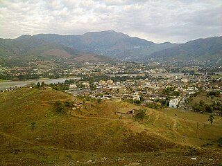
Lower Dir District is a district in the Khyber Pakhtunkhwa province of Pakistan. Timergara city is the district's headquarters and largest city. The Lower Dir district was formed in 1996, when Dir District was divided into Upper Dir and Lower Dir districts. On 22 January 2023, both Lower Dir and Upper Dir districts were further bifurcated to create a new Central Dir District. Lower Dir is famous for its beautiful snow-capped mountains, valleys, and pleasant weather. The primary industry in Lower Dir is tourism, which is now rapidly growing.

Upper Dir District is a district located in the Malakand Division of Khyber Pakhtunkhwa province of Pakistan. The city of Dir is its district headquarter. Geographically, it is located in the northern part of Pakistan. It borders with the Chitral district on the north, Afghanistan on the northwest, the Swat district on the east, and the Lower Dir district on the south. It shares 40 to 50 kilometers border with Afghanistan.
Lal qila is a town and a union council of Lower Dir District in Khyber Pakhtunkhwa, Pakistan. it lies in Dir, K.P.K., Pakistan and its geographical coordinates are 34°57′10″N 71°48′41E".
Lal Qilla is an administrative subdivision (Tehsil) of Lower Dir District in the Khyber Pakhtunkhwa province of Pakistan. The other tehsils of the district include:
- Adenzai Tehsil
- Balambat Tehsil
- Khall Tehsil
- Munda Tehsil
- Samar Bagh Tehsil
- Timergara Tehsil
Munda is an administrative subdivision (Tehsil) of Lower Dir District in the Khyber Pakhtunkhwa province of Pakistan. Munda is an administrative Tehsil under the jurisdiction of Samar Bagh, sub-division of Lower Dir District. It is listed among:
- Adenzai Tehsil
- Balambat Tehsil
- Khall Tehsil
- Lal Qilla Tehsil
- Munda Tehsil
- Samar Bagh Tehsil
- Timergara Tehsil
Samar Bagh is an administrative subdivision (Tehsil) of Lower Dir District in the Khyber Pakhtunkhwa province of Pakistan. The other tehsils of the district include:
- Adenzai Tehsil
- Balambat Tehsil
- Khall Tehsil
- Lal Qilla Tehsil
- Munda Tehsil`
- Timergara Tehsil

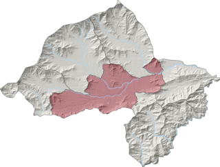
Timergara is an administrative subdivision (Tehsil) of Lower Dir District in the Khyber Pakhtunkhwa province of Pakistan. The other tehsils of the district include:
- Adenzai Tehsil
- Balambat Tehsil
- Khal Tehsil
- Lal Qilla Tehsil
- Munda Tehsil
- Samar Bagh Tehsil
Samar Bagh (barwa) is a Tehsil of Lower Dir District in Khyber Pakhtunkhwa, Pakistan.
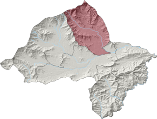
Adenzai is a tehsil located in Lower Dir District, Khyber Pakhtunkhwa, Pakistan. The tehsil includes the town of Chakdara.The name Adenzai is derived from the Adenzai clan of Yousafzai Pashtoon tribe. It is listed among:
- Adenzai Tehsil
- Balambat Tehsil
- Khall Tehsil
- Lal Qilla Tehsil
- Munda Tehsil
- Samar Bagh Tehsil
- Timergara Tehsil
Malakand is an administrative unit, known as Union council, of Malakand District in the Khyber Pakhtunkhwa province of Pakistan.

Malakand is an administrative unit, known as Union council, of Malakand District in the Khyber Pakhtunkhwa province of Pakistan.
Salarzai Tehsil is an administrative subdivision (tehsil) of Bajaur District in Khyber Pakhtunkhwa Province, Pakistan. Salarzai is the third largest of Bajaur District's seven tehsils.

Khall is an administrative subdivision (Tehsil) of Lower Dir District in the Khyber Pakhtunkhwa province of Pakistan. It is named after Khal (Bindi), a decorative dot worn by women on the centre of the forehead, as it is located in the centre of Dir. The other tehsils of the district include:
- Adenzai Tehsil
- Balambat Tehsil
- Lal Qilla Tehsil
- Munda Tehsil
- Samar Bagh Tehsil
- Timergara Tehsil

Barang Tehsil is an administrative subdivision (tehsil) of Bajaur District in Khyber Pakhtunkhwa, Pakistan. Barang is the sixth largest of Bajaur District's seven tehsils.

Mamund Tehsil is an administrative subdivision (tehsil) of Bajaur District in Khyber Pakhtunkhwa Province, Pakistan. Mamund is the largest of Bajaur District's seven tehsils.

Utman Khel Tehsil is an administrative subdivision (tehsil) of Bajaur District in Khyber Pakhtunkhwa Province, Pakistan. Utman Khel is the fifth largest of Bajaur District's seven tehsils.
Khar Bajaur Tehsil, sometimes shortened to Khar Tehsil, is an administrative subdivision (tehsil) of Bajaur District in Khyber Pakhtunkhwa, Pakistan. Khar Bajaur is the second largest of Bajaur District's seven tehsils.

NawagaiTehsil is an administrative subdivision (tehsil) of Bajaur District in Khyber Pakhtunkhwa Province, Pakistan. Nawagai is the fourth largest of Bajaur District's seven tehsils.

Bar Chamarkand Tehsil, alternatively written Bar Chamar Kand is an administrative subdivision (tehsil) of Bajaur District in Khyber Pakhtunkhwa Province, Pakistan. Bar Chamarkand is the smallest of Bajaur District's seven tehsils.
This page is based on this
Wikipedia article Text is available under the
CC BY-SA 4.0 license; additional terms may apply.
Images, videos and audio are available under their respective licenses.