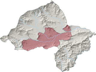
Orakzai District is a district in the Kohat Division of the Khyber Pakhtunkhwa province of Pakistan. Before 1973, it was part of FR Kohat. Up until 2018, it was an agency within the erstwhile Federally Administered Tribal Areas. However, with the merger of the FATA with Khyber Pakhtunkhwa, it attained the status of a district.

Mohmand District is a district in Peshawar Division of Khyber Pakhtunkhwa province in Pakistan. Until 2018, it was an agency of Federally Administered Tribal Areas, with merger of FATA with Khyber Pakhtunkhwa, it became a district. It was created as an agency in 1951. Mohmand is bordered by Bajaur District to the north, Khyber District to the south, Malakand and Charsadda districts to the east and Peshawar district to the southeast.

The Mullagori or Mulagori or Malagori is a Pashtun tribe present in Khyber District, tribal areas in Khyber Pakhtunkhwa, Pakistan. Historically, they are one of the smallest tribes of ethnic Pashtuns. They are considered as a sub-tribe of Momand Pashtun Ghoryakhel confederacy.
Mama Khel Banoochi is a town and union council in Bannu District of Khyber-Pakhtunkhwa.
Dhakki is a town and union council of Charsadda District in Khyber Pakhtunkhwa province of Pakistan. It is located at 34°18'17N 71°46'24E and has an altitude of 359 metres.
Charsadda Tehsil is a tehsil located in Charsadda District, Khyber Pakhtunkhwa, Pakistan.
Beka is a town and Union Council of Swabi District in the Khyber Pakhtunkhwa of Pakistan. It is part of Lahor Tehsil.
"BamKhel" in Pashto is a village and Union Council of Swabi District in Khyber Pakhtunkhwa, Pakistan. It is located at 34°6'0N 72°32'0E with an altitude of 321 metres (1,053 ft).

Saleem Khan or Saleem Khan Khel is a town and Union Council of Swabi District in Khyber-Pakhtunkhwa, Pakistan. The village is 2 kilometres (1.2 mi) to the south of Buner District at an altitude of 348 metres (1,142 ft).
Bara Bandai is a village in Swat, Khyber Pakhtunkhwa, Pakistan, known as an area crossed by Alexander The Great during his invasion of the subcontinent. The people of village Bara Bandai belong to subsection Naikpikhel of Yusufzai the biggest and largest tribe of Pashtun or Pakhtun tribes. It is one of the Provincially Administered Tribal Areas (PATA) of Pakistan. The village contains a small series of mountains and a forest, residential area starting from meadows of mountainsand merge with river swat on right bank, a village market, vast land for crops, number of canals, and a part of the Swat river. Mountains of the village include Usmani Sar, Kafar Ghat and Najia Top.
Barazai is a village situated in the east of Hazro Tehsil, Attock District in northern Punjab in Pakistan. Its altitude is 315 metres.
Mian Khan is a village in Katlang Tehsil, Mardan District of Khyber Pakhtunkhwa Pakistan. This village has historical significance and is considered the oldest village in the province of Khyber Pakhtunkhwa dating back to 190 BC, after the archaeological dig of 2014.
KhuduKhel or Khudu Khel is a tehsil and Totalai is its central town. Totalai is located near district Swabi in the northwestern region of the country.
Titter Khel is a village of Lakki Marwat District, Khyber Pakhtunkhwa, Pakistan. It is also known as Tattar Khel and as Umar Titter Khel.

Barang Tehsil is an administrative subdivision (tehsil) of Bajaur District in Khyber Pakhtunkhwa, Pakistan. Barang is the sixth largest of Bajaur District's seven tehsils.
Upper Mohmand Tehsil is a subdivision located in Mohmand District, Khyber Pakhtunkhwa, Pakistan. The population is 51,068 according to the 2017 census.

Khar Bajaur Tehsil, sometimes shortened to Khar Tehsil, is an administrative subdivision (tehsil) of Bajaur District in Khyber Pakhtunkhwa, Pakistan. Khar Bajaur is the second largest of Bajaur District's seven tehsils.

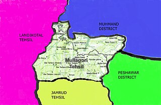
Mullagori Tehsil is a subdivision located in Khyber District, Khyber Pakhtunkhwa, Pakistan. It is located among the Tahtara hills on its west side and Peshawar on its east side. The population of Mullagori Tehsil is 40,188 according to the 2017 census. The population mostly belongs to the Mulagori tribe of the Pashtuns. This tehsil is situated to the north of the Khyber Pass in the Tahtara range. Their area extends from a little west of Chauki Sparsang to the crest of the Dabrai hill and from the Kabul River on the north to Lakka Sar on the south touching the land of the Kuki khel and Zakha khel, and a clan of the Shinwari. Their neighbors on the west are the Shalmanis and on the north, the Tarakzai Mohmands.
Masho Khel or Mashokhel is a historical village in the capital district Peshawar of province Khyber Pakhtunkhwa in Pakistan. The village is situated about 13km to the south of Peshawar cantonment. The sufi and philosophical poet of the 17th century, Abdul Hamid Baba, was also from this village. The spoken language in the village is Pashto and the people belong to the Pashtun's tribe Mohmand.


