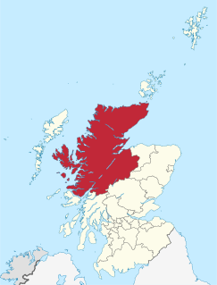
Highland is a council area in the Scottish Highlands and is the largest local government area in the United Kingdom. It was the 7th most populous council area in Scotland at the 2011 census. It shares borders with the council areas of Aberdeenshire, Argyll and Bute, Moray and Perth and Kinross. Their councils, and those of Angus and Stirling, also have areas of the Scottish Highlands within their administrative boundaries.

Golspie is a village in Sutherland, Highland, Scotland, which lies on the North Sea coast in the shadow of Ben Bhraggie. It has a population of around 1,350.

Achriesgill is a village that lies on the eastern bank of Loch Inchard in Lairg, Sutherland, in the Scottish council area of Highland.

Golspie railway station is a railway station serving the village of Golspie in the Highland council area of Scotland. It is on the Far North Line.
Ardachu is a village within the area of Rogart, Sutherland in the Scottish Highlands, within the Highland Council area. It lies on the River Fleet, west of Rogart.
Achlyness is a hamlet on the shores of Loch Inchard, located near Rhiconich, Sutherland, Scotland, within the council area of Highland.
Ardshealach is a small hamlet located close to the south west shore of Loch Shiel in Sunart, Lochaber, Highland, less than 1 mile southeast of Acharacle. It is in the Scottish council area of the Highland, Scotland.

Achuvoldrach is a small remote village on the west shore of the Kyle of Tongue in Sutherland, in the Highland region of Scotland. Achuvoldrach is linked to the village of Tongue by the Kyle of Tongue Causeway across the sea loch, on a west to east orientation.

Balmacara is a scattered village on the north shore of Loch Alsh near Kyle of Lochalsh, Ross-shire, Highland and is in the Scottish council area of the Highland, Scotland. In 1946, Lady Hamilton, bequeathed the 2750 Hectare Balmacara crofting estate to the people of Scotland, by donating it to the National Trust for Scotland. In 1954 the nearby Lochalsh House was conveyed to the Trust.

Bernisdale is a small township, near the head of Loch Snizort Beag, Isle of Skye in the Highlands and Islands and is in the Scottish council area of Highland.
Peinchorran is a remote settlement, lying at the end of the B883 road, on the north east headland of Loch Sligachan on the island of Skye in the Highlands of Scotland. It is in the council area of Highland.
Dalreavoch is a small crofting hamlet in Rogart in Sutherland, Scottish Highlands and is in the Scottish council area of Highland.

Kensaleyre is scattered crofting township, part of a group of settlements clustered around the A87 road on the shore of Loch Snizort Beag on the Trotternish peninsula of the island of Skye in the Highlands and Islands of Scotland. It is in the council area of Highland.
Bualintur is a remote township, which lies at the head of Loch Brittle on the island of Skye in the Highlands of Scotland and is in the Scottish council area of Highland. Accessed only by the Glen Brittle bridge (footbridge) that appears in the Royal Commission on Ancient and Historical Monuments in Scotland Bualintur affords some of the best views of the Cuillin hills, and is the point of access for several of Skye' s most dramatic coastal and forest walks. In recent history it was the central township of Glen Brittle, with the post office and school for the community. It was once a thriving community before the effects of the highland clearances and depopulation of the highlands and islands took place, and many ruined houses can be seen among the existing houses.

Inverkirkaig is extremely remote scattered crofting township, situated on the north eastern bay, of the sea loch Loch Kirkaig, in the Assynt district of Sutherland, Scottish Highlands and is in the Scottish council area of Highland.
Tote is a small crofting township, situated on the southwest coast of the Trotternish peninsula, at the head of the sea loch, Loch Snizort Beag on the island of Skye and is in the Scottish council area of Highland.
Badcall is a remote crofting township, located on the northern shore of the sea loch, Loch Inchard, in Sutherland, Scottish Highlands and is in the Scottish council area of Highland.

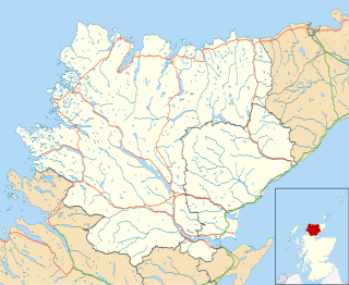
The River Brora is an east-flowing river in Sutherland in the Highlands of Scotland. It is formed where its headwater streams, the Féith Osdail, Allt Gobhlach and Allt nan Con-uisge meet at Dalnessie, then flows southeastwards down Strath Brora to Dalreavoch. The river then briefly turns northeast and then east, before turning southeastwards once again to pass through the three distinct basins of Loch Brora to enter the Moray Firth on the North Sea at the town of Brora. Its one principal tributary is the Black Water which enters on its left bank at Balnacoil. The Black Water is itself fed by the River Skinsdale and the Coirefrois Burn.


