
Guntur district is one of the twenty six districts in the Coastal Andhra region of the Indian state of Andhra Pradesh. The administrative seat of the district is located at Guntur, the largest city of the district in terms of area and with a population of 670,073. It has a coastline of approximately 100 km (62 mi) on the right bank of Krishna River, that separates it from Krishna district and NTR district. It is bounded on the south by Bapatla district and on the west by Palnadu district. It has an area of 2,443 km2 (943 sq mi) and with a population of 20,91,075 as per 2011 census of India.

Mothadaka is a village in Guntur district of the Indian state of Andhra Pradesh. It is located in Tadikonda mandal of Guntur revenue division. It forms a part of Andhra Pradesh Capital Region.
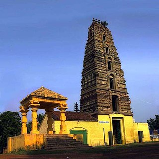
Chebrolu is a village in Guntur district of the Indian state of Andhra Pradesh. It is the headquarters of Chebrolu mandal in Tenali revenue division. It was once a Buddhist site and territorial capital of Kakatiya dynasty. The Archaeological excavations revealed Buddhist artefacts of Satavahana and Ikshavaku period.

Duggirala is a village in Guntur district of the Indian state of Andhra Pradesh. It is the mandal headquarters of Duggirala mandal in Tenali revenue division. It is one of the major turmeric trading centres in the country.

Ravela is a village in Guntur district of the Indian state of Andhra Pradesh. It is located in Tadikonda mandal of Guntur revenue division. It forms a part of Andhra Pradesh Capital Region.
Amruthalur is a village in Guntur district of the Indian state of Andhra Pradesh. It is the headquarters of Amruthaluru mandal in Tenali revenue division. The village forms a part of Andhra Pradesh Capital Region and is under the jurisdiction of APCRDA.
Pedakakani is a village in the Guntur district of the Indian state of Andhra Pradesh. It is located in Pedakakani mandal of Guntur revenue division. Hindu shrine of Shiva, Sri Bhramaramba Malleswara Swamy Temple is located in the village.
Phirangipuram is a village in Guntur district of the Indian state of Andhra Pradesh. It is located in Phirangipuram mandal of Guntur revenue division.

Tadikonda is a village in Guntur district of the Indian state of Andhra Pradesh. It is located in Tadikonda mandal of Guntur revenue division. It forms a part of Andhra Pradesh Capital Region.

Ganikapudi is a village in Guntur district of the Indian state of Andhra Pradesh. It is located in Prathipadu mandal of Guntur revenue division.
Ponnekallu is a village in Guntur district of the Indian state of Andhra Pradesh. It is located in Tadikonda mandal of Guntur revenue division. It forms a part of Andhra Pradesh Capital Region.
Namburu is a village in the Guntur district of the Indian state of Andhra Pradesh. It is located in Pedakakani mandal of Guntur revenue division.

Pedavadlapudi is a village in Guntur district of the Indian state of Andhra Pradesh. It is in Mangalagiri mandal. It is part of Mangalagiri Tadepalle Municipal Corporation It is part of Guntur revenue division.
Lakkaraju Garlapadu is a village in Palnadu district of the Indian state of Andhra Pradesh. It is located in Sattenapalle mandal of Guntur revenue division.

Kolakaluru is a neighborhood of Tenali city in Guntur district of the Indian state of Andhra Pradesh. It is located in Tenali mandal of Tenali revenue division. It forms a part of Andhra Pradesh Capital Region.

Guntur Urban mandal was a former mandal in Guntur district of the Indian state of Andhra Pradesh, before it was split into Guntur East and Guntur West mandals in 2018. It was under the administration of Guntur revenue division and its headquarters at Guntur, The mandal was bounded by Medikonduru, Tadikonda, Pedakakani, Edlapadu, Prathipadu, Vatticherukuru and Chebrole mandals.
Thalluru is a village in Palnadu district of the Indian state of Andhra Pradesh. It is located in Krosuru mandal of Guntur revenue division. It forms a part of Andhra Pradesh Capital Region.
Pesarlanka is a village in Guntur district of the Indian state of Andhra Pradesh. It is the located in Bhattiprolu mandal of Tenali revenue division. It forms a part of Andhra Pradesh Capital Region.

Nidumukkala is a village in Guntur district of the Indian state of Andhra Pradesh. It is located in Tadikonda mandal of Guntur revenue division. It forms a part of Andhra Pradesh Capital Region.

Lam is a village in Guntur district of the Indian state of Andhra Pradesh. It is located in Tadikonda mandal of Guntur revenue division. It forms a part of Andhra Pradesh Capital Region.
