
Banff National Park is Canada's oldest national park, established in 1885 as Rocky Mountains Park. Located in Alberta's Rocky Mountains, 110–180 kilometres (68–112 mi) west of Calgary, Banff encompasses 6,641 square kilometres (2,564 sq mi) of mountainous terrain, with many glaciers and ice fields, dense coniferous forest, and alpine landscapes. The Icefields Parkway extends from Lake Louise, connecting to Jasper National Park in the north. Provincial forests and Yoho National Park are neighbours to the west, while Kootenay National Park is located to the south and Kananaskis Country to the southeast. The main commercial centre of the park is the town of Banff, in the Bow River valley.
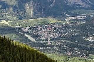
Banff is a town within Banff National Park in Alberta, Canada. It is located in Alberta's Rockies along the Trans-Canada Highway, approximately 126 km (78 mi) west of Calgary and 58 km (36 mi) east of Lake Louise. At 1,400 to 1,630 m above sea level, Banff is the community with the second highest elevation in Alberta, after Lake Louise.

Drumheller is a town on the Red Deer River in the badlands of east-central Alberta, Canada. It is 110 kilometres (68 mi) northeast of Calgary and 97 kilometres (60 mi) south of Stettler. The Drumheller portion of the Red Deer River valley, often referred to as Dinosaur Valley, has an approximate width of 2 kilometres (1.2 mi) and an approximate length of 28 kilometres (17 mi).

Canmore is a town in Alberta, Canada, located approximately 81 kilometres (50 mi) west of Calgary near the southeast boundary of Banff National Park. It is located in the Bow Valley within Alberta's Rocky Mountains. The town shares a border with Kananaskis Country to the west and south and the Municipal District of Bighorn No. 8 to the north and east. With a population of 14,798 in 2020, Canmore is the ninth-largest town in Alberta.
Frank is an urban community in the Rocky Mountains within the Municipality of Crowsnest Pass in southwest Alberta, Canada. It was formerly incorporated as a village prior to 1979 when it amalgamated with four other municipalities to form Crowsnest Pass.
Tumbler Ridge is a district municipality in the foothills of the B.C. Rockies in northeastern British Columbia, Canada, and a member municipality of the Peace River Regional District. With a population of 2,399 (2021) living in a townsite, the municipality encompasses an area of 1,558 km2 (602 sq mi) of mostly Crown land. The townsite is located near the confluence of the Murray River and Flatbed Creek and the intersection of Highway 52 and Highway 29 and includes the site of the Tumbler Ridge Secondary School and Tumbler Ridge Airport. It is part of the Peace River South provincial electoral district and the Prince George—Peace River—Northern Rockies federal riding.

Coleman is a community in the Rocky Mountains within the Municipality of Crowsnest Pass in southwest Alberta, Canada. It was formerly incorporated as a town prior to 1979 when it amalgamated with four other municipalities to form Crowsnest Pass.

Nordegg is a hamlet in west-central Alberta, Canada within Clearwater County. It is located in the North Saskatchewan River valley in the foothills of the Canadian Rockies, just east of the intersection of the David Thompson Highway and the Highway 734 spur of the Bighorn Highway. A former coal mining town, it was named after Martin Nordegg and the name probably means "North Corner" in a German dialect. The railway station name at the locality was called Brazeau rather than Nordegg at certain points in its history, but the local post office has always been named Nordegg. The name Brazeau is now obsolete.
Mt. Norquay is a mountain and ski resort in Banff National Park, Canada that lies directly northwest of the Town of Banff. The regular ski season starts early December and ends mid-April. Mount Norquay is one of three major ski resorts located in the Banff National Park.
Luscar is a ghost town in west-central Alberta, Canada that was once a coal mining community. It was in the foothills of the Northern Rockies about 12 kilometres (7.5 mi) northwest of Cadomin along the Bighorn Highway, at the end of the CN Railway line.
Beverly is a former urban municipality within the Edmonton Capital Region of Alberta, Canada. Beverly incorporated as a village on March 22, 1913 and became the Town of Beverly on July 13, 1914. It later amalgamated with the City of Edmonton on December 30, 1961. The population of Beverly was 8,969 at the time of amalgamation.
Coalspur is a nearly abandoned coal-mining and railroad town in Yellowhead County, Alberta. It is situated on Highway 47 beside the Embarras River in the foothills of the Canadian Rockies.
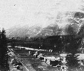
Anthracite is a ghost town located within Banff National Park in southern Alberta, Canada. It is named after the anthracite variety of coal.
East Coulee is a community within the Town of Drumheller, Alberta, Canada. It was previously a hamlet within the former Municipal District (MD) of Badlands No. 7 prior to the MD's amalgamation with the former City of Drumheller on January 1, 1998. It is also recognized as a designated place by Statistics Canada.

Rosedale is a community within the Town of Drumheller, Alberta, Canada. It was previously a hamlet within the former Municipal District (MD) of Badlands No. 7 prior to the MD's amalgamation with the former City of Drumheller on January 1, 1998. It is also recognized as a designated place by Statistics Canada.

The Banff National Park Pavilion, was designed by Frank Lloyd Wright and Francis Conroy Sullivan, one of Wright's only Canadian students. Designed in 1911, in the Prairie School style, construction began in 1913 and was completed the following year. The pavilion was built on the Recreation Grounds near the south end of the Bow River Bridge on the edge of the town of Banff, itself located within Banff National Park in Alberta. The last of only two Wright designs in Canada, the pavilion was demolished in 1938.
Georgetown is a ghost town in Alberta, Canada at the foot of Mount Rundle, near Banff.

Lille is a ghost town and former village in the Crowsnest Pass area of southwest Alberta, Canada. It was a company-built coal mining community that, between 1901 and 1912, hosted a population that grew to over 400. The mines at Lille closed in 1912, due primarily to weak coal prices, increasing production costs, and the increasingly poor quality of the coal. The community was then dismantled and most of its structures were moved elsewhere. Today the site is an Alberta Provincial Historic Resource and is known for the elegant ruins of a set of Bernard-style coke ovens that was imported from Belgium.

Midlandvale is a community within the Town of Drumheller, Alberta, Canada. It was previously a hamlet within the former Municipal District of Badlands No. 7 prior to being annexed by Drumheller in 1972. Now referred to as Midland by the Town of Drumheller, the community is located within the Red Deer River valley on North Dinosaur Trail, approximately 3 km (1.9 mi) west of Drumheller's main townsite.

Saunders Creek is a ghost town in west-central Alberta, Canada. Built as a coal mining community, the town existed from 1913 to 1954. It is located in the foothills of the Canadian Rockies near the David Thompson Highway, about 55 km west of the town of Rocky Mountain House. It was named for Saunders Creek, a small stream that runs immediately west of the townsite. The North Saskatchewan River flows nearby to the south.


