
Panchkula district was formed as the 17th district of the Indian state of Haryana on 15 August 1995. It comprises two sub divisions and two tehsils: Panchkula and Kalka. It has 264 villages, out of which 12 are uninhabited and ten wholly merged with towns or treated as census towns according to the 1991 census. There are five towns in the district: Barwala, Kalka, Panchkula, Pinjore and Raipur Rani. The total population of the district is 319,398 out of which 173,557 are males and 145,841 are females.

Mansa is a city of Punjab. It is the administrative headquarters of Mansa district and is situated on the Bathinda-Jind-Delhi railway line and also on the Barnala-Sardulgarh-Sirsa state highway.

Mansa district is a district in the state of Punjab, India. The district headquarters is Mansa city. Mansa district was formed on 13 April 1992 from the erst while district of Bathinda. The district has three tehsils: Mansa, Budhlada and Sardulgarh; and five development blocks: Mansa, Budhlada, Sardulgarh, Bhikhi and Jhunir.

Fatehabad district is one of the twenty two districts of the state of Haryana, India. Fatehabad was founded by Firuz Shah Tughlaq. Fatehabad district was carved out of Hisar district on 15 July 1997.
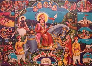
Gogaji is a folk deity, worshipped in the northern states of India especially in Rajasthan, Himachal Pradesh, Haryana, Uttarakhand, Punjab region, Uttar Pradesh, Jammu and Gujarat. He is a warrior-hero of the region, venerated as a saint and a 'snake-god'.

Batala is the eighth largest city in the state of Punjab, India in terms of population after Ludhiana, Amritsar, Jalandhar, Patiala, Bathinda, Mohali and Hoshiarpur. Batala ranks as the second-oldest city after Bathinda. It is a municipal corporation in Gurdaspur district in the Majha region of the state of Punjab. It is located about 32 km from Gurdaspur, the headquarters of the district. It is also a Police district. Batala holds the status of the most populated town of the district with 31% of the district's total population. It is the biggest industrial town in the district.
Chichawatni is a city in the Sahiwal District of the Punjab province of Pakistan. It is the administrative center of Chichawatni Tehsil. Situated near the old main road called Grand Trunk Road, it lies approximately 45 kilometres (28 mi) from the district capital, Sahiwal. In 2011, Chichawatni's population was estimated at 160,000.
Bazigar, or Goaars, are an ethnic group of north-western India. They are primarily found in Punjab and in Pakistan's Punjab, but there are also communities in Haryana, Uttar Pradesh, Delhi, Chandigarh, Himachal Pradesh, Jammu and Kashmir, and Rajasthan. They were previously nomadic with their main occupation the performance of acrobatics and other forms of entertainment, but they are now settled and engaged mainly in agricultural and similar forms of labour.

Bathinda district is in Malwa region of Punjab, India. The district encompasses an area of 3,385 square kilometers. By area, Bathinda district is the second-largest in Punjab, after Ludhiana district. It is bounded by Faridkot district and Moga district on the north, Muktsar district on the west, Barnala and Mansa districts on the east, and the state of Haryana on the south. Bathinda is cotton producing belt of Punjab.

Punjabi Hindus are ethnic Punjabis who are adherents of Hinduism; they constitute the third-largest religious subdivision within the Punjabi people, after Muslims and Sikhs, with a population numbering around 17 to 25 million. Punjabi Hindus are the second-largest religious group in the Indian state of Punjab. Apart from Punjab, they are also found in Haryana, Himachal Pradesh, Delhi, and Chandigarh today. Many of them have ancestry across the Punjab region as a whole, which was partitioned between India and Pakistan in 1947.
Bhadra is a city and a municipality in Hanumangarh district in the state of Rajasthan, India.

Bhawanigarh, earlier known as Dhode, is a town and a municipal council (Class-2) in the Sangrur district in the state of Punjab, India. It is also the headquarters of Bhawanigarh tehsil, which was formed in December 2016. The town is also called Dhode, after the clan of its original founders. The town lies 19 kilometres east of Sangrur on the Patiala-Sangrur road whereas Patiala is 39 kilometres east of Bhawanigarh. The literacy rate is higher than other places of Sangrur. Bhawanigarh is divided into 15 wards. The Bhawanigarh block consists of 66 villages in the Sangrur district.

Budhlada is a municipal council located in the Mansa district of the state of Punjab, India. The area's main industry is agriculture, which provides the majority of employment opportunities in the region. The municipal council of Budhlada is divided into 19 wards, and regular elections are held every five years. It has held the status of a Class II Municipal Council since the 1950s.
Kalanwali is a town and a municipal committee, nearby Sirsa in Sirsa district in the Indian state of Haryana. Being very near the Punjab border, most of the people in this area have Haryanvi & Punjabi as their mother tongue.
Kot Fatta is a city and a municipal council in Bathinda district in the Indian state of Punjab.
Veena Verma is a UK-based Punjabi short-story writer and poet from Punjab, India.
Dalelwala, sometimes spelled Dalelwala, is a town in the Budhlada tehsil of Mansa district in East Punjab, India. It is also a block of the district. Punjabi is the mother tongue as well as the official language here.
Borawal also in records written as Borewal is a village in Budhlada tehsil of Mansa district in the Indian state of Punjab. It is on Budhlada - Bhikhi road. The village has a very large pond, three gurdwaras, and C-pet camp. Welfare clubs such as U Meed and Saheed Udam Singh are present.
Vakilan Wala is the northernmost village of the Indian state of Punjab situated near Zira City, Punjab, and the international border of India and Pakistan. It is the administrative headquarters of Ferozepur District.
National Highway 148B starts at Kotputli, state of Rajasthan and ends at Bathinda, state of Punjab. The major towns are in succession of distance on this highway: Narnaul, Mahendergarh, Charkhi Dadri, Bhiwani, Hansi, Barwala, Bhimewala Tohana, Moonak, Jakhal, Bareta, Budhlada, Bhikhi, Mansa and Maur. This highway meets with National Highway 54 at Bathinda. The highway is 427 km (265 mi) long and runs all within the states of Haryana, Punjab and Rajasthan.

