Budhlada

Last updated

Budhlada
City in Punjab, India
PRTC Bus Station at Budhlada, Mansa, Punjab.jpg
PRTC Bus Station at Budhlada
India Punjab location map.svg
Red pog.svg
Budhlada
Location in Punjab, India
Coordinates: 29°56′N75°34′E / 29.93°N 75.57°E / 29.93; 75.57
Country India
State Punjab
District Mansa
Government
  BodyMunicipal Council
Elevation
211 m (692 ft)
Population
 (2011)
  Total26,172
Languages
  Official Punjabi and English
Time zone UTC+5:30 (IST)
PIN
151 502
Telephone code+91-1652-XXX-XXX
Vehicle registration PB 50
Literacy80.2%
Website budhladacity.in

Budhlada is a municipal council located in the Mansa district of the state of Punjab, India. The area's main industry is agriculture, which provides the majority of employment opportunities in the region. The municipal council of Budhlada is divided into 19 wards, and regular elections are held every five years. It has held the status of a Class II Municipal Council since the 1950s.

Contents

History

Residents of the village belonged to the Majhbi and Ramdasia communities, it was a part of the state of Kaithal. However, following their failure to assist the British during the 1857 insurgency, the village was annexed along with the rest of the territory. It later merged with Karnal District, a significant market in East Punjab, and was known for its suitability for the recruitment of military personnel, second only to Rohtak. One notable soldier recruited from Budhlada was Hawaldar Joginder Singh Datewas, who was awarded the Ashoka Chakra.

The British constructed a railway line connecting Budhlada to other regions of Punjab, leading to increased commerce and trade in the area. By 1901, the village had a population of roughly 3,500 people. During the 1930s and 1940s, it was renowned for its "boora khand" (superfine sugar), with a large factory near the railway station that dispatched consignments to Lahore and Karachi. However, this period of relative prosperity ended with the Partition of India in 1947, which cut off the town from these markets. [1]

As of 2021, the town's estimated population is approximately 35,000 people. Under British Raj rule, Budhlada was a "riyasat" (princely state). Kishna Maur, the brother of 'Lok Nike' (hero of the people), Jiauna Maur, was arrested by Budhlada police station. Both brothers were known for their support of the poor. Moreover, Sucha Singh Soorma's village of Samaon is nearly 18 km (11 mi). Although, Budhlada is also an important center of the Praja movement, with freedom fighters utilizing it for many freedom movements, it remained neglected after India's independence. Following the death of Sewa Singh Thikriwala, the president of the Riyasat Praja Mandal party, local residents began participating in the Praja Movement. The martyr Captain K. K. Gaur, social reformer Babu Hitabhilashi, and scientist Dr. M. L. Singla, [2] who headed the Chandrayaan program, are all from Budhlada.

Demographics

As of the 2011 Indian census, the total population of Budhlada was 26,172. [3] There were 13,832 males in the city (53%) and 12,340 females (47%). For every 1,000 men in Budhlada, there were 892 women. Furthermore, there were 2,882 children below six years of age, of which 1,599 were boys and 1,283 were girls. 11% of the total population was under six years of age. The number of working individuals in Budhlada was 8,726, with the remaining 17,446 unemployed. Out of 26,172 people, 18,680 people were literate. Budhlada has a literacy rate of 80.2%, higher than the national literacy rate of 74.0%. Sikhism and Hinduism are the major religions practiced in Budhlada, making up about 98% of the population.

Geography and climate

Budhlada is located at 29°56′N75°34′E / 29.93°N 75.57°E / 29.93; 75.57 [4] and has an average elevation of 211 metres (692 ft). The border of Haryana state is 25 kilometres (16 mi) away from the city.

Budhlada has a semi-arid climate, with temperatures ranging from 49 °C (120 °F) in the summer to 1 °C (34 °F) in the winter.

Budhlada
Climate chart (explanation)
J
F
M
A
M
J
J
A
S
O
N
D
 
 
10
 
 
21
9
 
 
19
 
 
24
11
 
 
7.9
 
 
30
15
 
 
9.8
 
 
37
20
 
 
20
 
 
41
25
 
 
38
 
 
42
28
 
 
90
 
 
39
28
 
 
84
 
 
37
27
 
 
52
 
 
36
24
 
 
9.4
 
 
33
18
 
 
1.4
 
 
28
13
 
 
3.6
 
 
23
9
Average max. and min. temperatures in °C
Precipitation totals in mm
Source: MSN World Weather
Imperial conversion
JFMAMJJASOND
 
 
0.4
 
 
70
48
 
 
0.8
 
 
75
52
 
 
0.3
 
 
86
59
 
 
0.4
 
 
99
68
 
 
0.8
 
 
106
77
 
 
1.5
 
 
108
82
 
 
3.6
 
 
102
82
 
 
3.3
 
 
99
81
 
 
2
 
 
97
75
 
 
0.4
 
 
91
64
 
 
0.1
 
 
82
55
 
 
0.1
 
 
73
48
Average max. and min. temperatures in °F
Precipitation totals in inches

Transport

Road

The city is located on the major roads SH-21 and NH-148B. The border of Haryana State is 25 km (16 mi) from the city, and the city is connected by road with Mansa 33 km (21 mi), Bathinda 88 km (55 mi), Chandigarh 174 km (108 mi), Fatehabad 65 km (40 mi) and Patiala 109 km (68 mi).

Railways

The railway station of the city was established in 1895 under the Southern Punjab Railway. It is now situated on the Delhi-Ferozpur main railway line of Northern Railway and is connected with other major cities in India, including Delhi, Mumbai, Guwahati, and Kolkata.

Air

The nearest airports to the city are Bathinda Airport (86 km) and Patiala Airport (89 km). The nearest International Airport is Chandigarh Airport (170 km).

Places of interest

Budhlada is 70 km (43 mi) away from Bathinda and is situated on the Delhi-Ferozpur rail line. A popular Gurudwara Braham Bunga is located in Dodra, 10 km (6.2 mi) from Budhlada. Every year, three main संगम (Gathering place) are held at Dodra in the months of March, September, and December. Sangat from all over the world comes over during these संगम events to take laha. The city is connected by rail and road to the cities Punjab and Haryana. Budhlada may not have as many tourist attractions as some of the other cities in Punjab, it does offer a few interesting places to visit which include Krishna Mandir, Shiva Mandir, Hanuman Mandir, Gurudwara Shri Guru Teg Bahadur Sahib, Guru Nanak College, YLS Academy of Education, Jagat Resorts, Pool Centre, New Judicial Court complex, ITI Stadium and Bharati Palace, Ram Bagh (park).

Education

The city has several schools that offer primary, secondary, and higher secondary education. Some of the most prominent government schools in the town include the Captain KK Gaur Girls School and Government Boys Senior Secondary School. There are some private institutes in the city for engineering and medical entrance examinations. National Institute of Computer Education and the ITI (Industrial Training Institute) offer technical education to the students. There is one government-funded college as well.The leading educational institutions of the area are Guru Nanak College, [5] LADM DAV Public School, [6] and Manu Vatika Day Boarding School. [7]

Related Research Articles

<span class="mw-page-title-main">Patiala</span> City in Punjab, India

Patiala is a city in southeastern Punjab, northwestern India. It is the fourth largest city in the state and is the administrative capital of Patiala district. Patiala is located around the Qila Mubarak constructed by the Sidhu Jat Sikh chieftain Ala Singh, who founded the royal dynasty of Patiala State in 1763, and after whom the city is named.

<span class="mw-page-title-main">Jalandhar</span> Metropolis in Punjab, India

Jalandhar is a city in the state of Punjab in India. With a considerable population, it ranks as the third most-populous city in the state and is the largest city in the Doaba region. Jalandhar lies alongside the historical Grand Trunk Road and is a well-connected junction for both rail and road networks.

<span class="mw-page-title-main">Kapurthala</span> City in Punjab, India

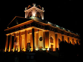
Kapurthala is a city in Punjab state of India. It is the administrative headquarters of Kapurthala District. It was the capital of the Kapurthala State, a princely state in British India. The aesthetic mix of the city with its prominent buildings based on French and Indo-Saracenic architecture self-narrate its princely past. It is also known as city of Palaces & Gardens. According to the 2011 census, Kapurthala is the least populated city in India.

<span class="mw-page-title-main">Mansa, Punjab</span> City in Punjab, India

Mansa is a city of Punjab. It is the administrative headquarters of Mansa district and is situated on the Bathinda-Jind-Delhi railway line and also on the Barnala-Sardulgarh-Sirsa state highway.

<span class="mw-page-title-main">Mansa district, India</span> District of Punjab in India

Mansa district is a district in the state of Punjab, India. The district headquarters is Mansa city. Mansa district was formed on 13 April 1992 from the erst while district of Bathinda. The district has three tehsils: Mansa, Budhlada and Sardulgarh; and five development blocks: Mansa, Budhlada, Sardulgarh, Bhikhi and Jhunir.

<span class="mw-page-title-main">Batala</span> City in Punjab, India

Batala is the eighth largest city in the state of Punjab, India in terms of population after Ludhiana, Amritsar, Jalandhar, Patiala, Bathinda, Mohali and Hoshiarpur. Batala ranks as the second-oldest city after Bathinda. It is a municipal corporation in Gurdaspur district in the Majha region of the state of Punjab. It is located about 32 km from Gurdaspur, the headquarters of the district. It is also a Police district. Batala holds the status of the most populated town of the district with 31% of the district's total population. It is the biggest industrial town in the district.

Kotkapura is a historic city in Faridkot district, Punjab, India. some 15 km from Faridkot City, 50 km from Bathinda, 40 km from Moga and 30 km from Muktsar in the state of Punjab, India. It is the largest city in the Faridkot District and has a large cotton market. It takes around 15 minutes by bus from Faridkot, 4 hours by road from Chandigarh and 2 hours from Ludhiana, and 8 hours from New Delhi by train to reach the city. It is a central city on route to Ganganagar, Ludhiana, Bathinda, Firozpur, etc. KotkKapura takes its name from its founder, Nawab Kapur Singh, and the word 'Kot', meaning a small fort – literally the 'Fort of Kapura'. The city is known for its "Dhodha Sweet" and "Atta Chicken" both of which are exported outside India.

<span class="mw-page-title-main">Bhawanigarh</span> Town in Punjab, India

Bhawanigarh, earlier known as Dhode, is a town and a municipal council (Class-2) in the Sangrur district in the state of Punjab, India. It is also the headquarters of Bhawanigarh tehsil, which was formed in December 2016. The town is also called Dhode, after the clan of its original founders. The town lies 19 kilometres east of Sangrur on the Patiala-Sangrur road whereas Patiala is 39 kilometres east of Bhawanigarh. The literacy rate is higher than other places of Sangrur. Bhawanigarh is divided into 15 wards. The Bhawanigarh block consists of 66 villages in the Sangrur district.

Kalanwali is a town and a municipal committee, nearby Sirsa in Sirsa district in the Indian state of Haryana. Being very near the Punjab border, most of the people in this area have Haryanvi & Punjabi as their mother tongue.

<span class="mw-page-title-main">Mandi Dabwali</span> Town in Haryana, India

Mandi Dabwali is a town and municipal committee and a Police district in Sirsa district in the Indian state of Haryana. It is located on the border of Haryana and Punjab. It is at a distance of 60 km from Sirsa City and 40 km from Bathinda, Punjab. Pin code of Mandi Dabwali is 125104 and STD code is 01668. Nearby Cities and towns include Bathinda, Malout, Kalanwali, Sirsa, Sangaria, Abohar, Rania, Hanumangarh and Ellenabad.

<span class="mw-page-title-main">Sri Muktsar Sahib</span> City in Punjab, India

Sri Muktsar Sahib is a historical city and district headquarters in Punjab, India. The 2011 Census of India put the total population of Sri Muktsar Sahib municipality at 117,085, making it the 14th largest city of Punjab, in terms of population. The second Guru of the Sikhs, Guru Angad was born in the village Matte-di-Sarai (Sarainaga) in the same district. Earlier the city was called Khidrana/Khidrane di dhab, the city was named Muktsar after the Battle of Muktsar in 1705 and the district headquarters in 1995. The government officially changed the name of the city to Sri Muktsar Sahib in 2012, though the city is still primarily referred to by its unofficial name – Muktsar.

Samana is a town and a municipal council, nearby Patiala City in Patiala district in the Indian state of Punjab.

Giddarbaha is a town and a municipal council in Muktsar district, in the Indian state of Punjab. It is 19 kilometres (12 mi) from the city of Malout, 30 kilometres (19 mi) from the city of Bathinda and 40 kilometres (25 mi) from the city of Muktsar. It lies on NH-7, which connects Fazilka (Punjab) to Mana (Uttarakhand) in India.

Maur is a suburb town of Bathinda City and a municipal council in Bathinda district in the Indian state of Punjab.It has a class II Municipal committee, located on the Bathinda- Delhi railway line, and the Bathinda-Mohali (Ajitgarh) state highway. This State Highway has now been upgraded to National Highway NH 148B. Maur Mandi is about 35 km from Bathinda city.

Bareta is a city and municipal council in the Mansa district in Southern Punjab, India. It is a small town that lies on the NH-148B.

<span class="mw-page-title-main">2012 Kabaddi World Cup (Circle style)</span> International kabaddi tournament in India

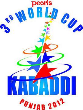
2012 Kabaddi World Cup was the third edition of the circle style Kabaddi World Cup, organised by the Government of Punjab. It was played in Punjab, India in various cities of the province from 1 to 15 December 2012 with teams from 16 countries. The opening ceremony of the tournament was held in Bathinda and the closing ceremony in Ludhiana.

Gill Kalan is a village in Rampura, Tehsil in Bathinda District of Punjab State, India. It is located 38 km towards East from District headquarters Bathinda. 5 km from Rampura. 177 km from State capital Chandigarh.

Verka is a suburb located in the Amritsar district of Punjab state, India. It is located on Batala Road and is situated on the northern part of Amritsar. Post code for Verka town is 143501. The famous milk plant Verka was named after the name of the town in 1973. Verka Railway Station is being electrified.

National Highway 148B starts at Kotputli, state of Rajasthan and ends at Bathinda, state of Punjab. The major towns are in succession of distance on this highway: Narnaul, Mahendergarh, Charkhi Dadri, Bhiwani, Hansi, Barwala, Bhimewala Tohana, Moonak, Jakhal, Bareta, Budhlada, Bhikhi, Mansa and Maur. This highway meets with National Highway 54 at Bathinda. The highway is 427 km (265 mi) long and runs all within the states of Haryana, Punjab and Rajasthan.

References

  1. "The bitter truth in Budhlada". The Tribune. 29 November 2016.
  2. "The moon man of Punjab". The Tribune India. 21 December 2008.
  3. "Census of India: Search Details". www.censusindia.gov.in. Retrieved 29 November 2019.
  4. Falling Rain Genomics, Inc - Budhlada
  5. "Guru Nanak College, Budhlada". Mansa.nic.in. Archived from the original on 7 August 2020. Retrieved 8 January 2020.
  6. "Lala Arjun Das Memorial DAV Public School, Budhlada". CBSE. Retrieved 8 January 2020.
  7. "Manu Vatika Sr. Sec. School, Budhlada". CBSE. Retrieved 8 January 2020.