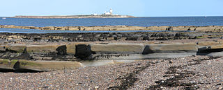
Coquet Island is a small island of about 6 hectares, situated 1.2 kilometres (0.75 mi) off Amble on the Northumberland coast, northeast England. It is included in the civil parish of Hauxley.

The River Coquet runs through the county of Northumberland, England, discharging into the North Sea on the east coast at Amble. It rises in the Cheviot Hills on the border between England and Scotland, and follows a winding course across the landscape ("Coquetdale"). The upper reaches are bordered by the Otterburn Ranges military training ground, and are crossed by a number of bridges built in the 20th century. It passes a number of small villages and hamlets, and feeds one of the lakes created by extraction of gravel that form the Caistron Nature Reserve, before reaching the town of Rothbury, where it is crossed by a grade II listed bridge. Below the town is Thrum Mill, the restoration of which was featured on Channel 4 television.

Cowshill is a village in County Durham, England. It is situated at the top of Weardale, between Lanehead and Wearhead. In the 2001 census Cowshill had a population of 156.

Harbottle is a village and civil parish in Northumberland, England about 10 miles (16 km) south-east of the Scottish border, in the southeastern part of the Cheviot Hills and inside Northumberland National Park. The village is the site of Harbottle Castle built by order of Henry II. Now in ruins, the castle was constructed by the Umfraville family to protect against invaders from Scotland.

Guyzance, historically Guizance, is a small village or hamlet and former civil parish, now in the parish of Acklington, in Northumberland, England. It is located on the River Coquet, roughly 6 miles south of Alnwick and around 3 miles west of Amble. Guyzance is one of only two places in Great Britain with a -zance ending; the other is Penzance in Cornwall. The similar names are co-incidence, however. In 1951 the parish had a population of 128.

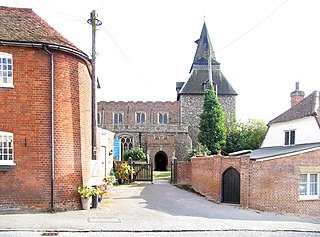
Alwinton is a village and former parish in Northumberland, England. Alwinton is named after the nearby River Alwin, and means farm on the River Alwin.
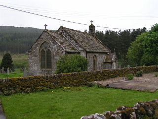
Byrness is a village within Rochester civil parish in Northumberland, England. It is approximately 37 miles (60 km) north-west of Newcastle upon Tyne on the A68, and is the last village in England before the A68 climbs the Cheviot Hills to cross Carter Bar into Scotland. Byrness's village church features a stained-glass window commemorating the workers who died during the building of Catcleugh Reservoir nearby. Much of the village was built by the Forestry Commission to house workers for the extensive forests that surround it. Situated on the Pennine Way, Byrness has an inn, campsite and other accommodation offering rest and sustenance for weary walkers.
Clifton is a hamlet in Northumberland, in England. The population is between 20 and 30. It is situated a short distance to the south of Morpeth, on the A1. It forms a trio with Hepscott and Glororum, a series of farms founded by the Brown brothers at the end of the 19th century. However, Clifton as a habitation stretches back earlier. In the 12th century lands were held at Clifton, under Roger de Merlay, by William of Clifton. There was a coaching inn here dating from the 17th century.

Ballidon is a village and civil parish in the Derbyshire Dales district of Derbyshire, England, on the edge of the Peak District National Park. According to the 2001 census it had a population of 79. The population at the 2011 Census remained less than 100. Details are maintained in the civil Parish of Aldwark, Derbyshire.

Barrow is a civil parish, in the unitary authority of Cheshire West and Chester and the ceremonial county of Cheshire, England. The civil parish contains the village of Great Barrow and the hamlets of Little Barrow, Broomhill and Stamford Bridge. Great Barrow is situated about 4.5 miles east-north-east of Chester, 6 miles north-west of Tarporley and 6 miles south of Frodsham.

Brushfield is a hamlet and civil parish in the Derbyshire Dales district of Derbyshire, England, in the Peak District National Park. It is about 8 miles east of Buxton. According to the 2001 census it had a population of 13. In 2007 it had just three houses. Several holiday lets are run by two separate families. One of these cottages is called the 'Old School House', a small one-bed house of stone.
Sharperton is a small settlement and former civil parish, now in the parish of Harbottle, in Northumberland, England. Sharperton is the site of a deserted medieval village, which was documented as having 14 taxpayers in 1296, and described as having two short rows of dwellings in 1632. There was also a bastle here. In 1951 the parish had a population of 36.
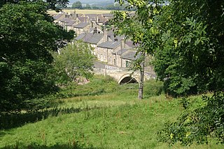
Thropton is a hamlet in Northumberland, England, located on the River Coquet, and its tributary Wreigh Burn. With a population of 458 it is situated 1.9 miles (3.1 km) west of the village of Rothbury connected by the B6431 near the junction of the Wreigh Burn and the River Coquet. In the hamlet is a stone bridge over the Wreigh Burn which was built in 1811. Thropton is on the edge of Northumberland National Park, and the surrounding area north and south of the hamlet consists of haughs, and also to the south on the opppisite side of the Coquet lies Simonside Hills, a hill range that has many crags dotted along it. <!—-Rulers —->
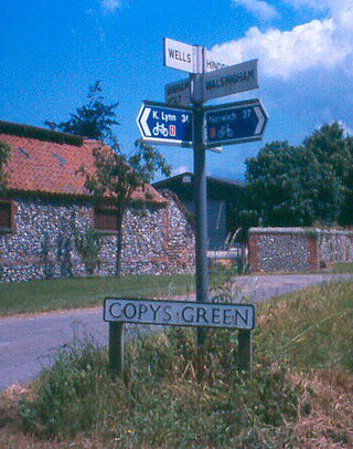
Wighton is a village and civil parish in the English county of Norfolk. The village is situated some 6 km (3.7 mi) south of the town of Wells-next-the-Sea, 12 km (7.5 mi) north of the town of Fakenham, and 45 km (28 mi) north-west of the city of Norwich. The medieval pilgrimage centre of Walsingham lies 3 km (1.9 mi) to the south.

Chew Green is the site of the ancient Roman encampment, commonly but erroneously called Ad Fines on the 1885-1900 edition of the Ordnance Survey map, in Northumberland, England, 8 miles (13 km) north of Rochester and 9 miles (14 km) west of Alwinton. The encampment was adjacent to Dere Street, a Roman road that stretched south to York (Eboracum), and almost on the present-day border with Scotland.
Wethersfield is a village and civil parish on the B1053 road in the Braintree district of Essex, England. It is near the River Pant. Wethersfield has a school, a social club, a fire station and one place of worship. Nearby settlements include the town of Braintree and the village of Finchingfield. The village probably gets its name from a Viking invader named Wuthha or Wotha, who controlled that particular "field" or clearing. Reverend Patrick Brontë, father of the Brontë sisters, was a young curate here in 1807, as was the Rev. John West, missionary to Canada, who married Harriet Atkinson here in 1807.

Kilham is a hamlet and civil parish in the English county of Northumberland, located 8.0 miles (12.9 km) west of Wooler, 12.0 miles (19.3 km) east of Kelso, 17.0 miles (27.4 km) south west of Berwick-upon-Tweed and 38.9 miles (62.6 km) north west of Morpeth. It lies on the northern edge of the Northumberland National Park in Bowmont Valley Northumberland. The hamlet, which consists of a small group of agricultural dwellings, is overlooked by Kilham Hill and the northern limits of the Cheviot Hills. The parish had a population of 131 in 2001, and includes the hamlets of Howtel and Pawston, along with the former upland township of Coldsmouth and Thompson's Walls. falling to less than 100 at the 2011 Census. Details are now included in the parish of Branxton

Denwick is a small village and civil parish in Northumberland, located about 1.4 miles (2 km) north-east of Alnwick.

Easington is a place and former civil parish, now in the parish of Belford about 14 miles from Alnwick, in the county of Northumberland, England. In 2011 the parish had a population of 143. The parish touched Adderstone with Lucker, Bamburgh, Belford and Middleton. The parish is coastal and stretches from Budle Bay in the east to Chesters Hill.

Shoreswood is a place and civil parish about 6 miles from Berwick-upon-Tweed, in the county of Northumberland, England. The parish includes the hamlets of Shoresdean and Thornton. In 2011 the parish had a population of 148. The parish touches Ancroft, Duddo, Horncliffe, Norham and Ord.

