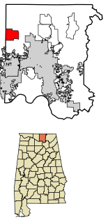
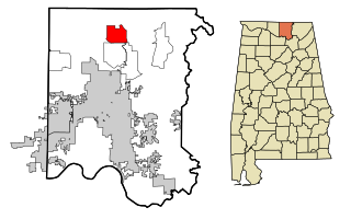
Cullman County is a county located in the north central portion of the U.S. state of Alabama. As of the 2010 census, the population was 80,406. Its county seat and largest city is Cullman. Its name is in honor of Colonel John G. Cullmann. It is a "moist" county in terms of availability of alcoholic beverages; the cities of Cullman, Good Hope and Hanceville allow sale of alcohol and are "wet" and the rest of the county is dry.

Albemarle County is a county located in the Piedmont region of the Commonwealth of Virginia. Its county seat is Charlottesville, which is an independent city and enclave entirely surrounded by the county. Albemarle County is part of the Charlottesville Metropolitan Statistical Area. As of the 2010 census, the population was 98,970, in 2018, it was estimated at 108,718.

Arab is a city in Marshall and Cullman counties in the northern part of the U.S. state of Alabama, located 10 miles (16 km) from Guntersville Lake and Guntersville Dam, and is included in the Huntsville-Decatur Combined Statistical Area. As of the 2010 census, the population of the city was 8,050.
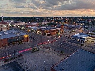
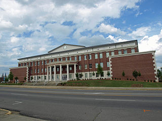
Cullman is the largest city and county seat of Cullman County, Alabama, United States. It is located along Interstate 65, about 50 miles (80 km) north of Birmingham and about 55 miles (89 km) south of Huntsville. As of the 2010 census it had a population of 14,775, with an estimated population of 16,034 in 2019.

Fairview is a town in Cullman County, Alabama, United States. At the 2010 census the population was 446, down from 522 in 2000. It incorporated in 1968.
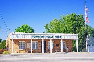
Holly Pond is a town in Cullman County, Alabama, United States. As of the 2010 census the town's population was 798. The town was incorporated in 1906.

Vestavia Hills, colloquially known simply as Vestavia, is a city in Jefferson and Shelby counties in the U.S. state of Alabama. It is a suburb of Birmingham and it is made up of Vestavia, Liberty Park, and Cahaba Heights. As of the 2010 census, its population was 34,033, up from 24,476 in 2000. It moved up from the fifth largest city in Jefferson County in 2000 to the third largest in 2010, behind Birmingham and Hoover.
Harvest is an unincorporated community and census-designated place (CDP) in the northwestern part of Madison County, Alabama, United States, and is included in the Huntsville-Decatur Combined Statistical Area. As of the 2010 census, the population of the community is 5,281.
Hazel Green is an unincorporated community and census-designated place (CDP) in Madison County, Alabama, United States, and is included in the Huntsville-Decatur Combined Statistical Area. As of the 2010 census, the population of the community was 3,630. The 2010 estimated population for the Hazel Green zip code 35750 was 12,783.

Annandale is a census-designated place (CDP) in Fairfax County, Virginia. The population of the CDP was 41,008 as of the 2010 United States Census. It is home to the oldest and largest branch of the Northern Virginia Community College system, and to one of the D.C. area's Koreatowns.

Belgreen is a census-designated place and unincorporated community in Franklin County, Alabama, United States, located nine miles west of Russellville and around 17 miles east of Red Bay on Alabama Highway 24. As of the 2010 census, its population was 129. Belgreen is a small district, composed of a condensed area of residency, the school, a small gas station, car wash, and a new Dollar General.

Wallace State Community College is a public community college in Hanceville, Alabama. Wallace State offers associate degrees. Founded in 1966 as the George C. Wallace State Trade School of Cullman County, the college currently enrolls approximately 6,000 students and offers more than 50 associate degree and certificate programs in academic, health, and technical programs.

Union Hill, also known as Wolff, is an unincorporated community in the eastern portion of Morgan County, Alabama, United States. It is one of the highest points on Brindlee Mountain, part of the Appalachian Mountain Range. The area consists of Union Hill School, Union Hill Grocery and New Canaan Baptist Church. It also hosts Station #2 of the Brindlee Mountain Fire Department, as well as Lecroy's, a popular restaurant up the road from the school. The broadcast tower for radio station WRSA Lite 96.9 is also located in Union Hill. A post office operated under the name Wolff from 1899 to 1905.

Ashland is an unincorporated community in Liberty Township, Henry County, Indiana.

Indian Creek Township is one of nine townships in Lawrence County, Indiana, United States. As of the 2010 census, its population was 2,775 and it contained 1,176 housing units.
Crane Hill is an unincorporated community in Cullman County, Alabama, United States, located in the southwestern portion of the county. The community of Crane Hill traces its history back to 1806, when the first settlers recorded their land titles. The area is named after the Sandhill Crane who fished the streams and roosted on a hill located just north of Mt. Zion Road.
Berlin is a town in Cullman County, Alabama, United States. It is located roughly five miles east of the city of Cullman in northern Alabama. U.S. Route 278 and Cullman County Road 747 intersect at Walker's Corner, considered to be the center of Berlin. The Berlin Community Center is located on U.S. Route 278, just west of the crossroads.
The Birmingham metropolitan area, sometimes known as Greater Birmingham, is a metropolitan area in north central Alabama centered on Birmingham, Alabama.

Joppa is a census-designated place (CDP) and unincorporated community in Cullman and Marshall counties, Alabama, United States. As of the 2010 census, its population was 501.
Vinemont is an unincorporated community in Cullman County, Alabama, United States, located roughly 7 miles (11 km) north of the city of Cullman. The population in July 2007 was 9,008. The Vinemont community includes the incorporated town of South Vinemont. Vinemont elementary, middle and high schools are located in South Vinemont.

