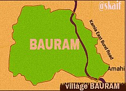
Bauram is a large village located in Darbhanga, Bihar, India. It is situated about 60km east of the district headquarters and 10km east of the sub-divisional headquarters. The area of Bauram is about 2400 bighas (961 acres ~4km2).
The main language of the village is Maithili. The majority of people living in Bauram are involved in agriculture where the main crops include wheat, barley, coriander, maize, mung bean, pigeon pea, cucumber, and sweet potato. In earlier times, gram (chana) provided good yields in the village.
Bauram was first discovered when India was under the rule of the Mughal Empire by a Jagdeeshpur Siwan's resident, Laung Chaudhary. Initially, he reached what was seen to be a village Asi (3–4km west to the village). Laung Chaudhary's second and third generations discovered the village when they were searching for their cattle's feed, where they found a heap of green grass. They thought about living in the village because it was the place where they can easily build their shelter from the surplus reeds available. They built shacks into colonies which are now known as "gaaon par (home)." Laung Chaudhary was a Hindu (Brahmin) before he became a Muslim (sheik), and this was the reason beyond the migration from Jagdishpur to Asi.
Demographics
There are about 2,297 families residing in Bauram; it has a total population of 11,455, in which 5,849 are males and 5,606 are females.[1]
For every 1000 males, there are 958 females. For every 1000 males age 18 and over, there are 975 females.
Bauram has a lower literacy than the average in Bihar. In 2011, the literacy rate of Bauram was 43.85% compared to the 61.80% for the whole of Bihar. In Bauram, male literacy stands at 52.15%, while the female literacy rate is 35.15%.
Languages and culture
The language spoken in Bauram is Maithili. Both Hindu and Muslim have their own style of dialect. Durga puja and Chhath are the most celebrated festivals among hindus. where as Muslims celebrate Eid ul-fitr and Eid al-Adha. In Bauram village, there are eight mosques, including Jama Masjid (The oldest mosque in Bauram), and two temples: Bhagwati asthan and Babaji Kuti.
Available public services
The new generation of the village inhabitants has a higher rate of education. Bauram has a primary school, a middle school, a high school, and the Kasturba Gandhi Balika Vidyalaya. There are many mobile towers which make mobile communication and internet services stronger. Furthermore, there are many Anganwadi centers in Bauram, and an active primary health center with a 24-hour ambulance service. Bharat Gas Agency Name (Baby Gas Gramin Vitrak) is also situated in it.
Regarding the future ones, there is a water tank being completed and is going to be started in few days.[needs update]
Madhubani is a city Municipal Corporation and headquarter of Madhubani district. Madhubani is situated in the Indian state of Bihar. It comes under Darbhanga Division. It is situated at 26 km northeast of Darbhanga City. The Madhuban Raj in Madhubani was created as a consequence. The word "Madhuban" means "forest of honey", from which Madhubani is derived, but sometimes it is also known as "madhu"+"vaani" meaning "sweet" "voice/language".
Samastipur is one of the thirty-eight districts of Bihar in India. The district headquarters are located at Samastipur. The district occupies an area of 2904 km² and has a population of 4,261,566.
Purnia District is one of the thirty-eight districts of the Indian state of Bihar. The city of Purnia is the administrative headquarters of this district. The city of Purnia has continued its tradition of hoisting the national flag at 12:07 am on every Independence Day since 1947. Purnia district is a part of Purnia Division. The district extends northwards from the Ganges river.
Khusrupur is a town and a notified area in Patna district of Bihar state, India. It is situated at the bank of river the Ganges. It is located on NH-30, 34 kilometers east of Patna. By rail, it is 31 kilometers east of Patna.
Makhdumpur is a town in the Bihar state of India. It is a major town of Jehanabad district and Patna-Gaya Corridor. The Barabar Hills/Barabar Caves tourist region is 10 KM South-East of Makhdumpur proper city.
Saurikh is a nagar panchayat in Kannauj district in the Indian state of Uttar Pradesh. Its old name was Sau-Rishi.It is located near main industrial and educational hub of Dibiyapur which is around at a distance of 55 km from the town.
Pudumadam is a village located in the Ramanathapuram district of the Indian state of Tamil Nadu. Situated near the old National Highway 49, which connects Kochi and Dhanushkodi, Pudumadam serves as a vital gateway to the picturesque Pamban Island. The village is approximately 25 kilometers away from the city of Ramanathapuram and 37 kilometers away from the renowned pilgrimage site of Rameswaram. The nearest train station is Uchippuli, located just 4 kilometers away from Pudumadam.
Pipra (पिपरा) a village in Mahottari District, Janakpur Zone in the Central Region of Nepal.
Bharaul is a small village situated in Bachhwara tehsil and located in Begusarai district of Bihar. It is one of 91 villages in Bachhwara Block along with villages like Rudauli and Arwa. Bharaul and Aagapur Kothi are on river-side of the Balan River opposite of each other. The nearest railway station from Bharaul is Bachhwara Junction which is 5.5 km away from the village. The main language of Bharaul is Maithili. Hindi is also spoken by most of the settlers. Bharaul village has a higher literacy rate compared to Bihar. In 2011, the literacy rate of Bharaul village was 63.64% compared to 61.80% of Bihar. In Bharaul, male literacy stood at 70.37% while female literacy rate was 56.45%.
Malmal Village is a village in India, situated about 560 mi east of New Delhi, the country's capital. It is situated 3 km from Kaluahi and approximately 17 km from Madhubani in the Indian state of Bihar.
Rampurwa is a village situated in Mehsi, East Champaran District in the Indian state of Bihar. The village is commonly known as Rampurwa among the localities. It lies in the Mirjapur Panchayat region. It is situated at the bank of river Burhi Gandak River on whose bank the village has flourished. It is well connected by road and railways. The nearest city Kaswa Mehsi in Mehsi, which is 2 km from the village. The nearest railway station is Mehsi railway station, which is around 5 km from the village.
Pakari Pakohi is a village in Muzaffarpur district of Bihar, India. This village is about 5 km west of Bhagwanpur and is located under the Marwan block. The village is connected with a road from Muzaffarpur to Rewa called Rewa road. The nearest railway station is Muzaffarpur and the nearest airport is Muzaffarpur Airport.
Meghaul is a panchayat village of Khodabandpur taluk, Begusarai district, in the Indian state of Bihar.
Babalad or Muttyna Babalad is a village in the southern state of Karnataka, India. It is located in Bijapur taluk of Bijapur district, Karnataka. It is nearly 25 km from the district headquarters, Bijapur. It's one of several small villages near Bijapur.
Adapur is a block in East Champaran district of Bihar, India. Adapur railway station is located 40 kilometres (25 mi) north of Motihari, the district headquarters. The state capital Patna is 175 kilometres (109 mi) in south. Adapur is located on the India - Nepal border. There are many villagers Near Adapur town peoples come to buy their daily essential things.
Khalispur is a village in the Sarairanjan block, Samastipur district, of the Indian state of Bihar.
Banjari is a large village in Gopalganj District of Bihar, India. It is located 1.3 km towards North-West from the district headquarters Gopalganj. Banjari village code is 1495000. It comes under the administration of Basdila Khas Gram panchayat.
Bagha Kusmar is a small town in the Madhubani district in northern Bihar state, India. It is under Phulparas subdivision. The distance between Bagha Kusmar and its district headquarters is 52 km (32 mi). The distance between Bagha Kusmar and town Khutauna is 7 km (4.3 mi).
Raithuwa is a village in Sohawal tehsil in Ayodhya district of the Indian state of Uttar Pradesh, India. The nearest town to Raithuwa is Bhadarsa which is 6 km away. Raituwa is 19 km south of district headquarters Ayodhya city.
Basuki Bihari is a big village in the Madhubani district in State of Bihar, India. According to India Population Census 2011 the population of the village is 14385. The majority of people of this village speak in Maithili language. The total area of the village is 13.62 km2. The village is divided into two Gram Panchayat Basuki Bihari North and Basuki Bihari South. The head of the Gram Panchayat is called as Mukhiya. Mukhiya is elected by adult people of the village. The election of Mukhiya is held by the Election Commission of Bihar state. This village is known for social cultural activities like Durga Puja, Chhath, Kali Puja and Sarswati Puja. The village is connected by State Highway No 75 from Darbhanga to Madhwapur. This village is only two kilometres far from the Indo-Nepal Border at Madhwapur in Madhubani district.
This page is based on this Wikipedia article Text is available under the CC BY-SA 4.0 license; additional terms may apply. Images, videos and audio are available under their respective licenses.