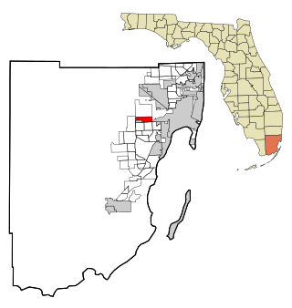
Fontainebleau(incorrectly spelled "Fountainebleau" in the 2000 census) is a census-designated place (CDP) in Miami-Dade County, Florida, United States. It is part of the Miami metropolitan area of South Florida. The population was 59,870 during the 2020 census.

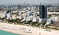
South Beach, also nicknamed colloquially as SoBe, is a neighborhood in Miami Beach, Florida. It is located east of Miami between Biscayne Bay and the Atlantic Ocean. The area encompasses Miami Beach south of Dade Boulevard.

Watson Island is a neighborhood and man-made island in Biscayne Bay, in Miami, Florida. It is located Immediately east of the Central Business District and Arts & Entertainment District neighborhoods of downtown Miami and is connected to the mainland and South Beach, Miami Beach by the MacArthur Causeway.
Ocean Drive is a major thoroughfare in the South Beach neighborhood of Miami Beach, Florida.
The Venetian Islands are a chain of artificial islands in Biscayne Bay in the cities of Miami and Miami Beach, Florida. The islands are, from west to east: Biscayne Island (Miami), San Marco Island (Miami), San Marino Island, Di Lido Island, Rivo Alto Island, and Belle Isle. Flagler Monument Island remains an uninhabited picnic island, originally built in 1920 as a memorial to railroad pioneer Henry Flagler. The islands are connected by bridges from the Miami mainland to Miami Beach.
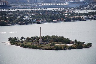
Flagler Memorial Island is an uninhabited artificial island of South Beach in the city of Miami Beach in Biscayne Bay, Florida. A 110-foot (34 m) high obelisk with allegorical sculptures at its base stands as a monument to Miami pioneer Henry M. Flagler, and was built in the center of the freshly constructed island in memory of Flagler, who died in 1913.

Miami Avenue is a 16.8-mile (27.0 km) main north–south street running through Coconut Grove, Brickell, Downtown, and Midtown in Miami, Florida. It is the meridian road dividing the street grid of Miami and Miami-Dade County into east and west avenues.

1800 Club is a residential skyscraper in the Edgewater neighborhood of Miami, Florida, United States. It was completed in 2007. The building is located east of Biscayne Boulevard and fronts Margaret Pace Park and Biscayne Bay. The building is 423 feet (129 m) tall, and contains 40 floors. Floors 1-5 are occupied by retail, while floors 6-40 are residential condominiums and apartments. The building is located at the corner of North Bayshore Drive and Northeast 18th Street. It was awarded the SARA Design Award in 2002 for its exterior architectural appeal.

Murano at Portofino is a highly affluent residential enclave tower /skyscraper in Miami Beach, Florida's South Beach. It is located directly on Biscayne Bay on the Miami Beach Marina. The tower, which opened in 2001, is 402 ft tall and contains 37 floors. It is located in the "SOFI" neighborhood.
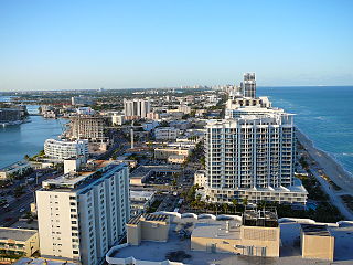
North Beach is a neighborhood of the city of Miami Beach, Florida. It is the northernmost section of the city, roughly bound by 63rd Street and Indian Creek Drive to the south and 87th Terrace to the north. It collectively refers to neighborhoods including Isles of Normandy, Biscayne Point, and La Gorce.
Coral Way is a neighborhood within Miami, Florida that is defined by Coral Way, a road established by Coral Gables founder George E. Merrick during the 1920s. It is located in Miami-Dade County, Florida.
Isle of Normandy or Normandy Island or Normandy Isles or Normandy Isle is a neighborhood of North Beach in the city of Miami Beach, Florida. It is located along the eastern shore of Biscayne Bay.

Biscayne Point is a neighborhood of North Beach in the city of Miami Beach, Florida. It is located just west of the main island that the city occupies, in the area of the city referred to as North Beach. It is actually on three islands, just north of Normandy Shores. Bridges connect the three islands which are accessible from 77th Street and from 85th Street by vehicles and from a pedestrian bridge at 80th Street.
The Serbin Open was a golf tournament on the LPGA Tour from 1953 to 1957. It was played at the Bayshore Golf Club in Miami Beach, Florida.
The Sunshine Open Invitational was a PGA Tour event that played for one year at the Bayshore Country Club in Miami Beach, Florida. The 72-hole tournament was held from March 23–26, 1961; and was won by then 25-year-old Gary Player with a score of 273. Player received $3,500 in winnings. Arnold Palmer finished second winning $2,300. The Bayshore Country Club, now known as Miami Beach Golf Club, opened in 1923.
The Miami Beach Open was a golf tournament on the PGA Tour in the late 1920s and again in the 1950s. It was held at several different courses in the Miami Beach, Florida area.

The Collins Park Neighborhood in Miami Beach sits on the north eastern point of the South Beach Historic District. Its boundaries are 17th street to the south, 25th Street to the north, the Atlantic Ocean to the east and Washington Avenue, Dade County Boulevard and Pinetree Drive to the west.
Margaret Pace Park is an 8-acre (3.2 ha) urban park located in the Arts & Entertainment District and Edgewater district of Greater Downtown Miami, Florida, U.S.A. The park is located on Biscayne Bay and has tennis courts as well as personal fitness equipment. It was created in the late 1960s and named in honor of Margaret Pace, who was a founder and past president of the Miami Garden Club. Pace was also chairwoman of Royal Palm State Park, which later became part of Everglades National Park, according to the Biscayne Times. A former vice president of the Miami Women’s Club, which is located next door, Pace fought development of the adjoining bayfront green space, which became the park and was named in her honor, according to the Miami Herald. Directly across North Bayshore Drive, several large condominium complexes built in the 2000s housing an economic bubble overlook the park:
Larkspur is a residential neighborhood in the Kempsville area of the independent city of Virginia Beach, Virginia. The neighborhood was founded by residential developer Clarence Byler in the 1950s after he noticed a new golf course, Kempsville Greens, had opened up near where he had recently been building homes.