
Kiribati, officially the Republic of Kiribati, is an island country in the Micronesia subregion of Oceania in the central Pacific Ocean. Its permanent population is over 119,000 as of the 2020 census, and more than half live on Tarawa atoll. The state comprises 32 atolls and one remote raised coral island, Banaba. Its total land area is 811 km2 (313 sq mi) dispersed over 3,441,810 km2 (1,328,890 sq mi) of ocean.

A tourist attraction is a place of interest that tourists visit, typically for its inherent or an exhibited natural or cultural value, historical significance, natural or built beauty, offering leisure and amusement.

Tourism in Australia is an important part of the Australian economy, and comprises domestic and international visitors. Australia is the fortieth most visited country in the world according to the World Tourism Organization. In the financial year 2018/19, tourism was Australia's fourth-largest export and over the previous decade was growing faster than national GDP growth. At the time it represented 3.1% of Australia's GDP contributing A$60.8 billion to the national economy.

Lautoka is the third largest metropolitan area in Fiji. It is on the west coast of the island of Viti Levu, in the Ba Province of the Western Division. Lying in the heart of Fiji's sugar cane-growing region, the city has come to be known as the Sugar City. Covering an area of 32 square kilometres, it had a population of 71,573 at the 2017 census, the most recent to date.
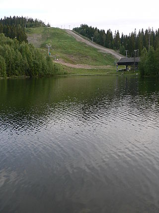
Tryvann is a small lake in Nordmarka, the forest area just north of Oslo city, near the Holmenkollen ski jump. By the water lies a cabin called Tryvannstua, in which there is a café open regularly during both summer and winter. On a hill above the lake looms the television tower Tryvannstårnet, visible from most of Oslo. Tryvann is the entry and beginning of Nordmarka. It is used all year around. The key purposes of this area in the winter are skiing and cross-country skiing, whereas in the summer it is more commonly used for walks in the forest and biking. When referring to Tryvann, it is mostly referred to as the Tryvann vinterpark.

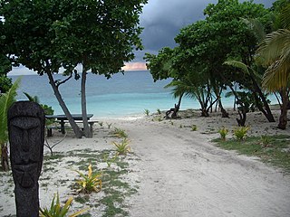
Beachcombing is an activity that consists of an individual "combing" the beach and the intertidal zone, looking for things of value, interest or utility. A beachcomber is a person who participates in the activity of beachcombing.

Nadi International Airport is the main international airport of Fiji as well as an important regional hub for the South Pacific islands, located by the coast on the Ba Province in the Western Division of the main island Viti Levu. Owned and operated by Fiji Airports Limited, it is the main hub of Fiji Airways and its domestic and regional subsidiary Fiji Link. The airport is located at Namaka, 10 km (6.2 mi) from the city of Nadi and 20 km (12 mi) from the city of Lautoka. In 2019, it handled 2,485,319 passengers on international and domestic flights. It handles about 97% of international visitors to Fiji, of whom 86% are tourists. Despite being Fiji's main airport, it is a considerable distance from the country's major population centre; it is located 192 km (119 mi) northwest of the country's capital and largest city Suva and its own airport, Nausori International Airport.

Tourism in China is a growing industry that is becoming a significant part of the Chinese economy. The rate of tourism has expanded over the last few decades since the beginning of reform and opening-up. The emergence of a newly rich middle class and an easing of restrictions on movement by the Chinese authorities are both fueling this travel boom. China has become one of world's largest outbound tourist markets. According to Euromonitor International, economic growth and higher incomes in nearby Asian countries will help China to become the world's number one tourist destination by 2030.
Tavewa is an island of the Yasawa Islands, measuring approximately 3 kilometres long by 1 km wide. It is part of the Nacula District that lies north-west of the Fijian island of Viti Levu.
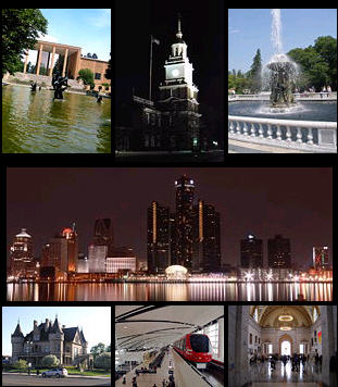
Tourism in metropolitan Detroit, Michigan is a significant factor for the region's culture and for its economy, comprising nine percent of the area's two million jobs. About 19 million people visit Metro Detroit spending an estimated 6 billion in 2019. In 2009, this number was about 15.9 million people, spending an estimated $4.8 billion. Detroit is one of the largest American cities and metropolitan regions to offer casino resort hotels. Leading multi-day events throughout Metro Detroit draw crowds of hundreds of thousands to over three million people. More than fifteen million people cross the highly traveled nexus of the Ambassador Bridge and the Detroit-Windsor Tunnel annually. Detroit is at the center of an emerging Great Lakes Megalopolis. An estimated 46 million people live within a 300-mile (480 km) radius of Metro Detroit.

Tourism in Nicaragua has grown considerably recently, and it is now the second largest industry in the nation. Nicaraguan President Daniel Ortega has stated his intention to use tourism to combat poverty throughout the country.
Tourism in Mauritius is an important component of the Mauritian economy as well as a significant source of its foreign exchange revenues. The tourism industry is also a major economic pillar on the island of Rodrigues; however, tourism has not been developed in Agaléga Islands. Mauritius is mostly appreciated by tourists for its natural environment and man-made attractions, the multi-ethnic and cultural diversity of the population, the tropical climate, beaches and water sports.
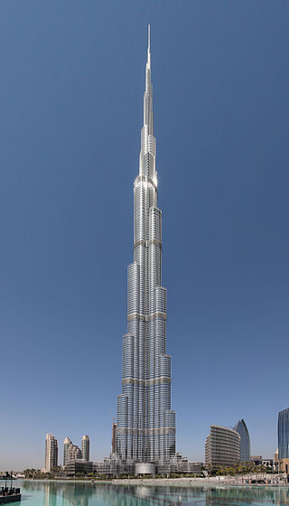
There are many tourist attractions in Dubai, resulting from the large scale construction boom. Dubai received 14 million tourists from all around the world in 2015. Euromonitor ranked the world's 150th most visited city by international tourists in 2009; Dubai ranked 7th. Dubai welcomed 14.36M visitors in 2022. Dubai's economy relies on many sections of the "state", one of the most important being tourism, in 2014 total 70,475,636 passengers traveled through Dubai Airport.
Niue Hotel was a hotel in Niue, Oceania, the largest on the island. The government-owned hotel was built in 1975 in the hope of stimulating tourism. It was badly damaged in 1990, but was refurbished and expanded. However, it struggled to attract guests and in 2000 was put up for sale and leased for use as a medical school. The buildings were destroyed by a hurricane in 2004.

Matamanoa is a small, private island within the Mamanuca Islands of Fiji in the South Pacific. The islands are a part of the Fiji's Western Division.
Navini is a small, private island within the Mamanuca Islands of Fiji in the South Pacific. The islands are a part of the Fiji's Western Division.
Kadavulailai is a small, private island within the Mamanuca Islands of Fiji in the South Pacific. The islands are a part of the Fiji's Western Division.
South Sea Island is a tiny island within the Mamanuca Islands of Fiji in the South Pacific. The islands are a part of the Fiji's Western Division.
Malamala is a tiny islet within the Mamanuca Islands of Fiji in the South Pacific. The islands are a part of the Fiji's Western Division.

William Justin Mullahey was an American airline executive who was a long-time employee of Pan American Airways, helping the company expand its presence across the Pacific. He also played a large role in developing tourism throughout the Pacific Islands, including leading the development of the Pacific Asia Travel Association.

