Fiji, officially the Republic of Fiji, is an island country in Melanesia, part of Oceania in the South Pacific Ocean. It lies about 1,100 nautical miles north-northeast of New Zealand. Fiji consists of an archipelago of more than 330 islands—of which about 110 are permanently inhabited—and more than 500 islets, amounting to a total land area of about 18,300 square kilometres (7,100 sq mi). The most outlying island group is Ono-i-Lau. About 87% of the total population of 924,610 live on the two major islands, Viti Levu and Vanua Levu. About three-quarters of Fijians live on Viti Levu's coasts: either in the capital city of Suva; or in smaller urban centres such as Nadi—where tourism is the major local industry; or in Lautoka, where the sugar-cane industry is dominant. The interior of Viti Levu is sparsely inhabited because of its terrain.
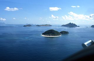
The Mamanuca Islands of Fiji are a volcanic archipelago lying to the west of Nadi and to the south of the Yasawa Islands. The group, a popular tourist destination, consists of about 20 islands, but about seven of these are covered by the Pacific Ocean at high tide.
Malolo is an inhabited volcanic island in the Pacific Ocean, near Fiji. Malolo was used as a tribe name in Survivor: Ghost Island. Malolo Island is the largest of the Mamanuca Islands and is home to two villages.
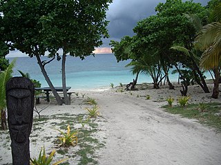
Castaway Island is an island of the Mamanuca Group in Fiji. It is inhabited, with a tourist resort on its west side. The island has an area of 70 hectares.

Tokoriki is an island within the Mamanuca Islands of Fiji in the South Pacific. It is home to two independent resorts, the privately owned luxury award winning resort Tokoriki Island Resort for honeymooners and couples and nearby is the Marriott Sheraton Resort & Spa. The island has its own reef which has many diving and snorkeling sites.
Mana Island belongs to the Mamanuca Islands, Fiji. Mana was used as a tribe name in Survivor: Game Changers.

Malolo Lailai, also known as Plantation Island, is the second largest and most developed of the Mamanuca Islands, lying 20 kilometres west of Nadi on Fiji's main island Viti Levu. Malolo Lailai is the centre of tourism in the Mamanuca Islands, and consists of four resorts, a number of residential houses, a marina and a golf course. The island can be reached in 50 minutes from Port Denarau by the Malolo Cat, a catamaran, or by Malolo Lailai Airport, a 10-minute flight from Nadi International Airport. Separated by a small isthmus which can be walked at low tide, the larger island of Malolo Levu lies north-west of Malolo Lailai.

Severe Tropical Cyclone Joni was a damaging tropical cyclone that impacted the island nations of Tuvalu and Fiji. It was first noted within the South Pacific Convergence Zone at the start of December 1992, as a shallow tropical depression in the vicinity of the island nation Tuvalu. Over the next few days the system gradually developed further as it affected Tuvalu, before it was declared to be a tropical cyclone and named Joni by the Fiji Meteorological Service (FMS) during December 7. Over the next couple of days the system intensified further as it was steered south-westwards and posed a threat towards the Fijian dependency of Rotuma and the French territory of Wallis and Futuna. The system subsequently peaked as a Category 4 severe tropical cyclone on the Australian tropical cyclone intensity scale as it approached the Fijian Islands during December 10. Over the next couple of days the system moved through the Fijian Islands, before it became an extratropical cyclone during December 13. The system was last noted during the next day as it was absorbed by a mid-latitude trough of low pressure to the east of New Zealand.

Severe Tropical Cyclone Sina was the only named tropical cyclone to develop within the South Pacific basin during the 1990–91 season. The system was first noted as a shallow depression within the South Pacific Convergence Zone to the west of Wallis Island. Over the next three days the system moved towards the west-northwest, before it was named Sina during November 24, after it had developed into a tropical cyclone. Over the next couple of days the system intensified further and developed an eye feature as it erratically moved towards Fiji. Sina subsequently peaked in intensity during November 26, before the system passed through the Fijian Islands over the next two days as it started to gradually weaken. Sina subsequently passed just to the north of Tongatapu in Tonga during November 29, before it passed about 160 km (100 mi) to the south of Niue and near the Southern Cook Islands during the next day. The system subsequently rapidly weakened and became an extratropical cyclone during December 1, before they were absorbed by an advancing trough of low pressure near 50°S on December 4.
Vomo is an island within the Mamanuca Islands of Fiji in the South Pacific. It is located on the cusp of the Yasawa Islands.

Matamanoa is a small, private island within the Mamanuca Islands of Fiji in the South Pacific. The islands are a part of the Fiji's Western Division.
Navini is a small, private island within the Mamanuca Islands of Fiji in the South Pacific. The islands are a part of the Fiji's Western Division.
Kadomo is an island within the Mamanuca Islands of Fiji in the South Pacific. The islands are a part of the Fiji's Western Division.

Beachcomber is a small, private island within the Mamanuca Islands of Fiji in the South Pacific, which in turn are a part of Fiji's Western Division.
Kadavulailai is a small, private island within the Mamanuca Islands of Fiji in the South Pacific. The islands are a part of the Fiji's Western Division.
Treasure Island is a small island within the Mamanuca Islands of Fiji in the South Pacific. The islands are a part of the Fiji's Western Division.
South Sea Island is a tiny island within the Mamanuca Islands of Fiji in the South Pacific. The islands are a part of the Fiji's Western Division.
Vomolailai is a tiny uninhabited islet within the Mamanuca Islands of Fiji in the South Pacific. The islands are a part of the Fiji's Western Division.
Malamala is a tiny islet within the Mamanuca Islands of Fiji in the South Pacific. The islands are a part of the Fiji's Western Division.
Wadigi is a tiny islet within the Mamanuca Islands of Fiji in the South Pacific. The islands are a part of the Fiji's Western Division.
