Fiji, officially the Republic of Fiji, is an island country in Melanesia, part of Oceania in the South Pacific Ocean. It lies about 1,100 nautical miles northeast of New Zealand. Fiji consists of an archipelago of more than 330 islands—of which about 110 are permanently inhabited—and more than 500 islets, amounting to a total land area of about 18,300 square kilometres (7,100 sq mi). The most outlying island group is Ono-i-Lau. About 87% of the total population of 883,483 live on the two major islands, Viti Levu and Vanua Levu. About three-quarters of Fijians live on Viti Levu's coasts: either in the capital city of Suva; or in smaller urban centres such as Nadi—where tourism is the major local industry; or in Lautoka, where the sugar-cane industry is dominant. The interior of Viti Levu is sparsely inhabited because of its terrain.

Kiribati, officially the Republic of Kiribati, is an independent island nation in the central Pacific Ocean. The permanent population is over 119,000 (2020), more than half of whom live on Tarawa atoll. The state comprises 32 atolls and one raised coral island, Banaba. They have a total land area of 811 square kilometres and are dispersed over 3.5 million km2 (1.4 million sq mi).

Oceania is a geographic region that includes Australasia, Melanesia, Micronesia and Polynesia. Spanning the Eastern and Western Hemispheres, Oceania has a land area of 8,525,989 square kilometres (3,291,903 sq mi) and a population of over 41 million. When compared with the continents, the region of Oceania is the smallest in land area and the second smallest in population after Antarctica.

Tonga, officially named the Kingdom of Tonga, is a Polynesian country, and also an archipelago comprising 169 islands, of which 36 are inhabited. The archipelago's total surface area is about 750 square kilometres (290 sq mi) scattered over 700,000 square kilometres (270,000 sq mi) of the southern Pacific Ocean. As of 2016, Tonga had a population of 100,651, 70% of whom resided on the main island, Tongatapu.

The Pacific Islands Forum (PIF) is an inter-governmental organization that aims to enhance cooperation between countries and territories of the Pacific Ocean, including formation of a trade bloc and regional peacekeeping operations. It was founded in 1971 as the South Pacific Forum (SPF), and changed its name in 1999 to "Pacific Islands Forum", so as to be more inclusive of the Forum's Oceania-spanning membership of both north and south Pacific island countries, including Australia. It is a United Nations General Assembly observer.

Nadi International Airport is the main international airport of Fiji as well as an important regional hub for the South Pacific islands, located by the coast on the western side of the main island Viti Levu. Owned and operated by Fiji Airports Limited, It is the main hub of Fiji Airways and its domestic and regional subsidiary Fiji Link. The airport is located at Namaka 10 km from the city of Nadi and 20 km from the city of Lautoka. In 2019, it handled 2,485,319 passengers on international and domestic flights. It handles about 97% of international visitors to Fiji, of which 86% are tourists. Despite being Fiji's main airport it is a considerable distance from the country's major population centre; located 192 kilometres (119 mi) northwest of the country's capital and largest city Suva and its airport, Nausori International Airport.

Tokoriki is an island within the Mamanuca Islands of Fiji in the South Pacific. It is home to two resorts, the privately owned luxury resort Tokoriki Island Resort for honeymooners and couples and Sheraton Resort & Spa, Tokoriki Island. The island has its own reef which has many diving and snorkeling sites.
Mana Island belongs to the Mamanuca Islands, Fiji. Mana was used as a tribe name in Survivor: Game Changers.
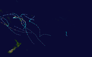
The 2020–21 South Pacific cyclone season was an average season where most tropical cyclones formed within the South Pacific Ocean to the east of 160°E. The season officially started on November 1, 2020, and officially ended on April 30, 2021, however a tropical cyclone could form at any time between July 1, 2020, and June 30, 2021, and would count towards the season total. During the season, tropical cyclones will be officially monitored by the Fiji Meteorological Service (FMS), Australian Bureau of Meteorology (BoM), New Zealand's MetService. The United States Armed Forces through the Joint Typhoon Warning Center (JTWC) will also monitor the basin and issue unofficial warnings for American interests. RSMC Nadi attaches a number and an F suffix to tropical disturbances that form in or move into the basin while the JTWC designates significant tropical cyclones with a number and a P suffix. RSMC Nadi, TCWC Wellington and TCWC Brisbane all use the Australian Tropical Cyclone Intensity Scale and estimate windspeeds over a period of ten minutes, while the JTWC estimated sustained winds over a 1-minute period, which are subsequently compared to the Saffir–Simpson hurricane wind scale (SSHWS).

Yanuya is an island within the Mamanuca Islands of Fiji in the South Pacific. The island is close to the Tokoriki island.
Vomo is an island within the Mamanuca Islands of Fiji in the South Pacific. It is located on the cusp of the Yasawa Islands.

Matamanoa is a small, private island within the Mamanuca Islands of Fiji in the South Pacific. The islands are a part of the Fiji's Western Division.
Navini is a small, private island within the Mamanuca Islands of Fiji in the South Pacific. The islands are a part of the Fiji's Western Division.

Beachcomber is a small, private island within the Mamanuca Islands of Fiji in the South Pacific, which in turn are a part of Fiji's Western Division.
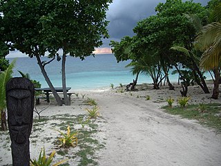
Kadavulailai is a small, private island within the Mamanuca Islands of Fiji in the South Pacific. The islands are a part of the Fiji's Western Division.
Treasure Island is a small island within the Mamanuca Islands of Fiji in the South Pacific. The islands are a part of the Fiji's Western Division.
South Sea Island is a tiny island within the Mamanuca Islands of Fiji in the South Pacific. The islands are a part of the Fiji's Western Division.
Vomolailai is a tiny uninhabited islet within the Mamanuca Islands of Fiji in the South Pacific. The islands are a part of the Fiji's Western Division.
Malamala is a tiny islet within the Mamanuca Islands of Fiji in the South Pacific. The islands are a part of the Fiji's Western Division.
Wadigi is a tiny islet within the Mamanuca Islands of Fiji in the South Pacific. The islands are a part of the Fiji's Western Division.