Chimneystack Run is a tributary of Coles Creek in Columbia County, Pennsylvania, in the United States. It is approximately 1.8 miles (2.9 km) long and flows through Sugarloaf Township. The watershed of the stream has an area of 1.07 square miles (2.8 km2). The stream's headwaters are located between Red Rock Mountain and Central Mountain. It has no named tributaries, but one unnamed tributary. Chimneystack Run is named after Chimneystack Rock. Wild trout inhabit the stream. Glaciation has affected the geography and geology in its vicinity.
Big Run is a tributary of West Branch Fishing Creek in Sullivan County, Pennsylvania, in the United States. It is approximately 1.0 mile (1.6 km) long and flows through Davidson Township. The watershed of the stream has an area of 0.51 square miles (1.3 km2). The stream is somewhat acidic, with a pH that ranged from 4.02 to 4.65 during a study on the watershed of Fishing Creek. Wisconsinan Till, Boulder Colluvium, and bedrock consisting of sandstone and shale all occur in the vicinity of the stream.
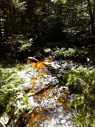
Shingle Mill Run is a tributary of West Branch Fishing Creek in Sullivan County, Pennsylvania, in the United States. It is approximately 2.4 miles (3.9 km) long and flows through Davidson Township. The watershed of the stream has an area of 2.60 square miles (6.7 km2). The stream has one named tributary, Bearwallow Run. Shingle Mill Run is designated as an Exceptional Value stream and has a population of native trout. The stream has high water quality and is slightly acidic. Boulder Colluvium and bedrock consisting of sandstone and shale can be found near the stream.
Swanks Run is a tributary of West Branch Fishing Creek in Sullivan County, Pennsylvania, in the United States. It is approximately 1.5 miles (2.4 km) long and flows through Davidson Township. The watershed of the stream has an area of 1.33 square miles (3.4 km2). The stream is considered to be Class A Wild Trout Waters for its entire length. Boulder Colluvium, alluvium, and bedrock consisting of sandstone and shale can be found in the vicinity of the stream. It is on Pennsylvania State Game Lands.

Boston Run is a tributary of Kitchen Creek in Luzerne County, Pennsylvania, in the United States. It is approximately 1.2 miles (1.9 km) long and flows through Fairmount Township. The watershed of the creek has an area of 0.66 square miles (1.7 km2). Old-growth forests are in the vicinity and wild trout naturally reproduce in the stream. The surficial geology nearby features Wisconsinan Outwash, Wisconsinan Till, fill, and bedrock consisting of sandstone and shale.

Laurel Run is a tributary of Huntington Creek, in Luzerne County, Pennsylvania, in the United States. It is approximately 1.8 miles (2.9 km) long and flows through Ross Township. The watershed of the stream has an area of 1.29 square miles (3.3 km2). Wild trout naturally reproduce in the stream. The surficial geology in the area mainly consists of Wisconsinan Till, Wisconsinan Ice-Contact Stratified Drift, and bedrock consisting of sandstone and shale. The stream is designated as a Least Disturbed Stream.
Deep Hollow is a tributary of West Branch Fishing Creek in Luzerne County, Pennsylvania, in the United States. It is approximately 0.8 miles (1.3 km) long and flows through Davidson Township. The watershed of the stream has an area of 0.53 square miles (1.4 km2). Wild trout naturally reproduce in the stream. The surficial geology in the area mainly features bedrock consisting of sandstone and shale, as well as a small amount of Boulder Colluvium and alluvium.
Spencer Run is a tributary of West Creek in Columbia County, Pennsylvania, in the United States. It is approximately 2.1 miles (3.4 km) long and flows through Jackson Township and Benton Township. The watershed of the stream has an area of 2.07 square miles (5.4 km2). Wild trout naturally reproduce in the stream. The surficial geology in the area mainly features Illinoian Till, Illinoian Leg, alluvium, colluvium, and bedrock.
York Hollow is a tributary of West Creek in Columbia County, Pennsylvania, in the United States. It is approximately 2.5 miles (4.0 km) long and flows through Jackson Township and Sugarloaf Township. The watershed of the stream has an area of 1.47 square miles (3.8 km2). Wild trout naturally reproduce in the stream. The surficial geology in the area mainly consists of Illinoian Till, Illinoian Lag, alluvium, colluvium, and bedrock.
Slip Run is a tributary of West Branch Fishing Creek in Sullivan County, Pennsylvania, in the United States. It is approximately 1.1 miles (1.8 km) long and flows through Davidson Township. The watershed of the stream has an area of 0.53 square miles (1.4 km2). Wild trout naturally reproduce within the stream. Surficial geology in the area mainly consists of alluvium, Boulder Colluvium, Wisconsinan Till Moraine, Wisconsinan Till, and bedrock consisting of sandstone and shale.
Green Run is a tributary of Spring Brook in Lackawanna County, Pennsylvania, in the United States. It is approximately 4.7 miles (7.6 km) long and flows through Spring Brook Township, Roaring Brook Township, and Scranton. The watershed of the stream has an area of 4.32 square miles (11.2 km2). It is considered to be Class A Wild Trout Waters throughout its entire length. Numerous macroinvertebrate taxa also inhabit the stream. The surficial geology in the vicinity of the stream's lower reaches mainly consists of Wisconsinan Till, bedrock, and Boulder Colluvium.
Plank Bridge Creek is a tributary of Spring Brook in Lackawanna County, Pennsylvania, in the United States. It is approximately 2.4 miles (3.9 km) long and flows through Spring Brook Township. The watershed of the creek has an area of 1.26 square miles (3.3 km2). It is inhabited by wild trout throughout its length. The surficial geology in its vicinity mainly consists of Wisconsinan Till, bedrock, Boulder Colluvium, alluvium, and wetlands.
Kellum Creek is a tributary of Roaring Brook in Lackawanna County, Pennsylvania, in the United States. It is approximately 2.9 miles (4.7 km) long and flows through Madison Township. The watershed of the creek has an area of 2.56 square miles (6.6 km2). The creek is considered to be Class A Wild Trout Waters. A planned trail is in its vicinity. The surficial geology in the area consists of alluvium, bedrock, peat bogs, wetlands, Boulder Colluvium, and Wisconsinan Till.
Lake Run is a tributary of Roaring Brook in Lackawanna County, Pennsylvania, in the United States. It is approximately 1.6 miles (2.6 km) long and flows through Covington Township. The watershed of the stream has an area of 3.44 square miles (8.9 km2). It has one named tributary, which is known as Emerson Run. Lake Run is considered to be Class A Wild Trout Waters. The surficial geology in its vicinity consists of Wisconsinan Ice-Contact Stratified Drift, Wisconsinan Till, Boulder Colluvium, alluvium, bedrock, sand and gravel pits, fill, wetlands, peat bogs, and a lake.
Windfall Run is a tributary of Baker Run in Wyoming County, Pennsylvania, in the United States. It is approximately 1.6 miles (2.6 km) long and flows through Noxen Township. The watershed of the stream has an area of 1.68 square miles (4.4 km2). The stream itself is classified as Class A Wild Trout Waters by the Pennsylvania Fish and Boat Commission. The surficial geology in its vicinity includes Wisconsinan Till and bedrock.
North Branch Bowman Creek is a tributary of Bowman Creek in Luzerne County, Pennsylvania, in the United States. It is approximately 3.2 miles (5.1 km) long and flows through Fairmount Township and Ross Township. The watershed of the creek has an area of 2.63 square miles (6.8 km2). The creek is not designated as an impaired waterbody. The surficial geology in its vicinity includes Wisconsinan Till, alluvial fan, Boulder Colluvium, alluvium, bedrock, and a peat bog. The creek is mostly in Pennsylvania State Game Lands and Ricketts Glen State Park.
South Branch Bowman Creek is a tributary of Bowman Creek in Luzerne County, Pennsylvania, in the United States. It is approximately 3.0 miles (4.8 km) long and flows through Fairmount Township and Ross Township. The watershed of the creek has an area of 3.92 square miles (10.2 km2). The surficial geology in its vicinity consists of alluvial fan, alluvium, Wisconsinan Ice-Contact Sratified Drift, fill, lakes, Boulder Colluvium, Wisconsinan Till, Wisconsinan Bouldery Till, wetlands, and bedrock. Most of the creek is in Ricketts Glen State Park. It has one named tributary, which is known as Cherry Run. The creek's watershed is designated as a High-Quality Coldwater Fishery and a Migratory Fishery.
Cherry Run is a tributary of South Branch Bowman Creek in Luzerne County, Pennsylvania, in the United States. It is approximately 2.1 miles (3.4 km) long and flows through Fairmount Township and Ross Township. The watershed of the stream has an area of 1.65 square miles (4.3 km2). The surficial geology in its vicinity consists of alluvial fan, alluvium, bedrock, Wisconsinan Till, wetlands, and a peat bog. The stream has cascades and contains wild trout.

West Branch Little Muncy Creek is a tributary of Little Muncy Creek in Sullivan County and Lycoming County, in Pennsylvania, in the United States. It is approximately 3.5 miles (5.6 km) long and flows through Davidson Township in Sullivan County and Franklin Township and Jordan Township in Lycoming County. The watershed of the creek has an area of 4.33 square miles (11.2 km2). The creek has one named tributary, which is known as West Creek. The surficial geology in the vicinity of West Branch Little Muncy Creek includes alluvium, bedrock, fill, Wisconsinan and Reworked Illinoian Till, Wisconsinan Till, Wisconsinan Flow-Till, Wisconsinan Till Moraine, and Boulder Colluvium. The creek designated as a Coldwater Fishery and a Migratory Fishery and is being considered for addition to the wild trout waters list of the Pennsylvania Fish and Boat Commission.
Little Indian Run is a tributary of Little Muncy Creek in Lycoming County and Sullivan County, in Pennsylvania, in the United States. It is approximately 4.3 miles (6.9 km) long and flows through Franklin Township and Jordan Township in Lycoming County and Davidson Township in Sullivan County. The watershed of the stream has an area of 3.36 square miles (8.7 km2). The surficial geology in the stream's vicinity mainly consists of alluvium, bedrock, Wisconsinan Till, Wisconsinan Till Moraine, and Wisconsinan Ice-Contact Stratified Drift. Wild trout naturally reproduce within the stream. A number of sawmills were historically located on the stream.

