
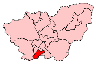
Ecclesall Ward—which includes the neighbourhoods of Bents Green, Ecclesall, Greystones, Millhouses, and Ringinglow—is one of the 28 electoral wards in City of Sheffield, England. It is located in the southwestern part of the city and covers an area of 3.6 square miles. The population of this ward in 2007 was 19,211 people in 7,626 households, reducing to 6,657 at the 2011 Census. Ecclesall ward is one of the four wards that make up the South West Community Assembly and one of five wards that make up the Sheffield Hallam Parliamentary constituency. The Member of Parliament is Olivia Blake, a Labour MP. Ecclesall is one of the least socially deprived wards in the entire country, with a 2002 deprivation score of 4.7—making it the 8,105th most deprived ward out of 8,414 wards in the country. The demographic consists largely of white, middle-class families.

Beauchief Abbey is a medieval monastic house now serving as a parish church in the southern suburbs of Sheffield, England. Beauchief is pronounced bee-chiff.
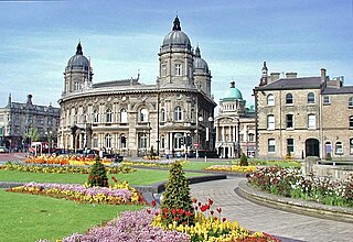
Queen's Gardens is a sequence of gardens in the centre of Kingston upon Hull, England. They are set out within a 9.75-acre (4 ha) area that until 1930 was filled with the waters of Queen's Dock. As the dock was not fully filled in, the gardens are largely below the level of the surrounding streets.

Abbeydale Industrial Hamlet is an industrial museum in the south of the City of Sheffield, England. The museum forms part of a former steel-working site on the River Sheaf, with a history going back to at least the 13th century. It consists of a number of dwellings and workshops that were formerly the Abbeydale Works—a scythe-making plant that was in operation until the 1930s—and is a remarkably complete example of a 19th-century works. The works are atypical in that much of the production process was completed on the same site. A more typical example of water-powered works in the area can be found at Shepherd Wheel.

Millhouses is a neighbourhood in the City of Sheffield, England. It is located in Ecclesall ward; in the south-western portion of the city on the northwest bank of the River Sheaf. Its origins lie in a small hamlet that grew around the Ecclesall Corn Mill. It has a population of 4,424.

Shepherd Wheel is a working museum in a former water-powered grinding workshop situated on the Porter Brook in the south-west of the City of Sheffield, England. One of the earliest wheels on the River Porter, it is one of the few remaining—and effectively complete—examples of this kind of enterprise, one that used to be commonplace in the Sheffield area. Its 5.5 m (18 ft) diameter overshot water wheel is powered from a large dam stocked with water diverted from the Porter Brook. The workshops, dam, goit and weir are Grade II listed, and the site is a Scheduled Ancient Monument.
Sheffield Heeley is a constituency represented in the House of Commons of the UK Parliament since 2015 by Louise Haigh, a member of the Labour Party. It is located in the city of Sheffield, South Yorkshire.

Abbeydale and Abbeymead are modern suburbs of the city of Gloucester in the county of Gloucestershire, England. They lie approximately 3 miles south-east of the city centre, and are bounded by the suburbs of Coney Hill to the north west, Barnwood and Hucclecote to the north and north east, Matson to the south west and the M5 motorway to the south and east. Mostly connected with Segregated Bicycle Paths into Gloucester city along Metz Way. The village of Upton St Leonards is directly across the M5 motorway.
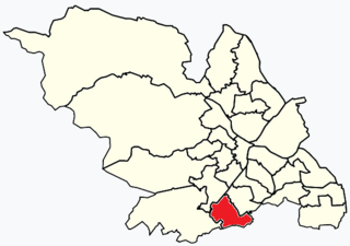
Beauchief and Greenhill ward—which includes the districts of Batemoor, Beauchief, Chancet Wood, Greenhill, Jordanthorpe, and Lowedges—is one of the 28 electoral wards in City of Sheffield, England. It is located in the southern part of the city and covers an area of 2.4 square miles (6.2 km2). The population of this ward in 2016 was estimated to be 19,669 people in 9,209 houses.

Abbeydale is an area in the City of Sheffield, England that follows the valley of the River Sheaf. It covers many districts of Sheffield in the south-west of the city running roughly from Heeley Bridge in the district of Heeley to Dore Road between Beauchief and Totley. It is named for the Abbey that existed at Beauchief from the 12th century to 1537.
Sheffield is the most geographically diverse city in England. Lying in the eastern foothills of the Pennines, the city nestles in a natural amphitheatre created by several hills and the confluence of five rivers: Don, Sheaf, Rivelin, Loxley and Porter. As such, much of the city is built on hillsides, with views into the city centre or out to the countryside. The city is roughly one third urban, one third rural and one third in the Peak District. At its lowest point the city stands just 29 metres above sea level at Blackburn Meadows on the Rotherham border, rising up to over 500 m in some parts of the city to a peak of 548m at High Stones on the Derbyshire border; however, 89% of the housing in the city is between 100 and 200 metres above sea level. Over 95% of the population resides in the main urban area.
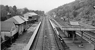
Beauchief railway station was in Sheffield, South Yorkshire, England.

Millhouses and Ecclesall railway station was a railway station in the Millhouses district of Sheffield, South Yorkshire, England.

Sheffield Tramway was an extensive tramway network serving the English city of Sheffield and its suburbs.
Buildings and structures in Sheffield have been constructed over a time-span ranging from the 13th century to the present day. The majority of Sheffield's older buildings were built during the Industrial Revolution, with many medieval buildings demolished in the 19th century; some older buildings were lost during the Sheffield Blitz. Sheffield can only lay claim to five Grade I listed buildings, two of which are in the city centre.

Hutcliff Wood and Marriott Wood are two areas of ancient woodland in Sheffield, South Yorkshire, England. They occupy the steep southeastern side of the Abbeydale valley between Archer Road and Abbey Lane, separated by the River Sheaf and the railway line from Millhouses Park. Hutcliffe Wood Road divides the two areas of woodland, Hutcliff Wood to the west and Marriott Wood to the east.

The Limb Brook is a stream in Sheffield, South Yorkshire, England. It rises at the village of Ringinglow, flowing east through Whirlow and Ecclesall Woods into Abbeydale in the Beauchief area, where it merges with the River Sheaf. Near this point part of the stream has been diverted to provide the goit for the Abbeydale Industrial Hamlet millpond, and this channel flows through what is now Beauchief Gardens.
Abbeydale Road and Abbeydale Road South is a road in Sheffield, South Yorkshire, England. It leads south-west from the suburb of Highfield to the railway bridge over the Dore and Chinley railway, before becoming Baslow Road. The road begins at a junction with London Road near the former Royal Hotel public house.
Abbeydale Grange School was a mixed comprehensive school in Sheffield, England, established in 1958 and closed after the 2009/10 academic year, after being listed amongst the schools with the worst GCSE examination results.

Fulwood Old Chapel is a Unitarian place of worship in the Fulwood district of western Sheffield, South Yorkshire. It is a member of the General Assembly of Unitarian and Free Christian Churches, the umbrella organisation for British Unitarians.

